Available Copies from Independent Booksellers
Price: US$5800.00 + shipping
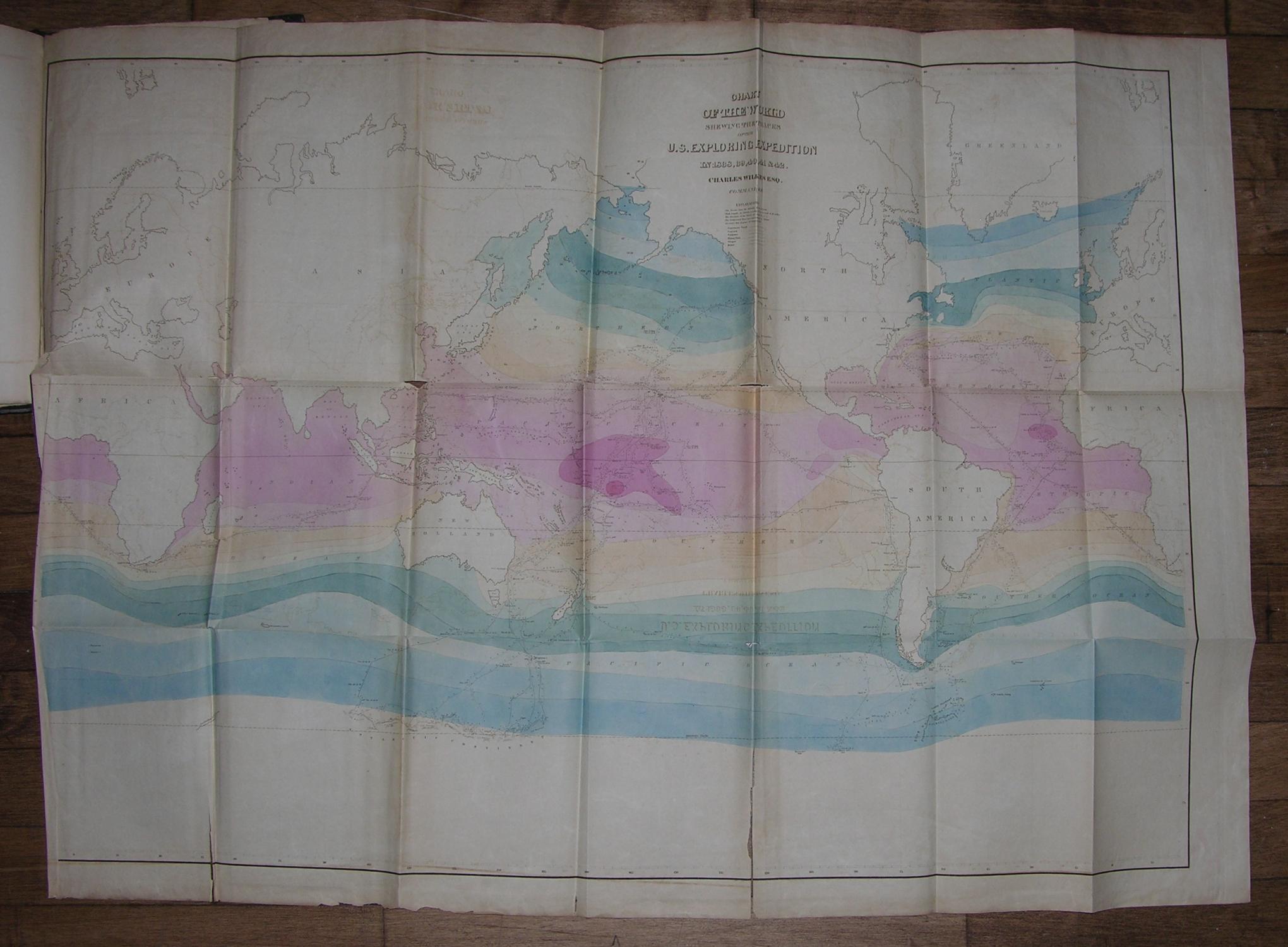
Description: 5 text volumes and 1 atlas volume. Imperial 8vo., signed in 4's, (11 ½ x 7 ¾ inches). Half titles. 5 fine folding lithographed maps on banknote paper, one with original hand color (some separation along folds, one or two short marginal tears, some browning and offsetting); frontispiece maps in volumes IV and V, 7 double-page engraved maps, engraved frontispieces, 61 engraved plates, numerous in-text illustrations (pale staining to upper margin of a few plates). Original brown publisher's cloth, decorated in blind and lettered in gilt, the smooth spines with gilt vignettes (rebacked to style, preserving most of the original spines, a few pale stains). Provenance: Christie's Sale 1820: The Frank S. Streeter Library: Important Navigation, Pacific Voyages, Cartography, Science; 16 - 17 April 2007. First trade edition. "THE UNITED STATES EQUIVALENT TO THE VOYAGES OF JAMES COOK, JEAN FRANCOIS GALAUP DE LAPEROUSE, ALEJANDRO MALASPINA, AND IVAN FEDOROVICH KRUZENSHTERN FOR ENGLAND, FRANCE, SPAIN, AND RUSSIA, AND THE MARITIME EQUIVALENT OF LEWIS AND CLARK" (W. Michael Mathes). The third overall edition: Haskell's "unofficial issue" 2B, limited to 1,000 copies. Preceded only by the official government edition, published in 1844 and limited to 100 copies, and the unofficial edition, published by Lea and Blanchard in 1845 and limited to 150 copies. The large maps in the atlas are: "Chart of the World Shewing the Tracks of the U.S. Exploring Expedition in 1838, 39, 40, 41 & 42. Charles Wilkes Esq. Commander," engraved by Sherman & Smith N.Y. A fine map following Mercator's projection, showing winds and currents, the tracks of the ships Vincennes, Peacock, Porpoise, Flying Fish, Oregon, and Relief. "Chart of the Antarctic Continent Shewing the Icy Barrier Attached to it. Discovered by the U.S. Ex. Ex. Charles Wilkes. Esq, Commander 1840," engraved by Sherman & Smith, N.Y. A fine map with Victoria (Australia) and Van Dieman's Land shaded in, showing the tracks of the ships Vincennes, Peacock, Porpoise, and Flying Fish along the coast of Antarctica, with five profile views of the Antarctic continent. "Chart of the Viti Group or Feejee Islands by the U.S. Ex. Ex. Charles Wilkes Esq. Commander 1840," engraved by Sherman & Smith, N.Y. A very detailed chart of the islands. "Map of the Oregon Territory by the U.S. Ex. Ex. Charles Wilkes Esqr. Commander. 1841," engraved by J. H. Young & Sherman & Smith, N.Y. A magnificent map (reduced in size for the later editions) with an inset of the "Columbia River Reduced from a Survey Made by the U.S. Ex. Ex. 1841" showing the area of Oregon Territory as claimed by the United States, extending well north of Vancouver, west from the Black Hills, north to just above the fifty-third parallel, and south to Cape Mendocino. This is the "first official [U.S.] chart of any portion of the West Coast and covers the coast from Cape Mendocino to Queen Charlotte Islands. The inset of the Columbia River includes geography extending as far as Walla Walla. It is a handsome map printed on imported paper from copperplates purchased in France from the Depot de la Marine. The engravers themselves were European craftsmen who not only executed the work, but also trained the American apprentices, including the artist James McNeill Whistler, who served as an engraver on the Coast Survey and learned his craft from those who engraved the Wilkes charts" (Cohen, Mapping the West, pp. 120-122). "Map of Part of the Island of Hawaii Sandwich Islands Shewing the Craters and Eruption of May and June 1840. By the U.S. Ex. Ex. 1841," engraved by Sherman & Smith, Sc. N.Y. Showing the area from Hilo to the top of Mauna Loa. Wilke's celebrated circumnavigation explored extensively the coast of South America, the South Seas, Antarctica, California and the Northwest. Departing in August 1838, Wilkes rounded Cape Horn; crossed the Pacific surveying, charting, and exploring the Tuamotus, Tahiti, and Samoa; and reached Sydney, Australia, in November
Seller: Arader Galleries - AraderNYC, New York, NY, U.S.A.