Available Copies from Independent Booksellers

G J Whyte Melville. The Gladiators A tale of Rome and Judaea. Rand McNally, USA, 1891.
Price: US$5.00 + shipping
Condition: Poor
Description: The Gladiators A tale of Rome and Judaea
Seller: Celt Books, Kenner, LA, U.S.A.
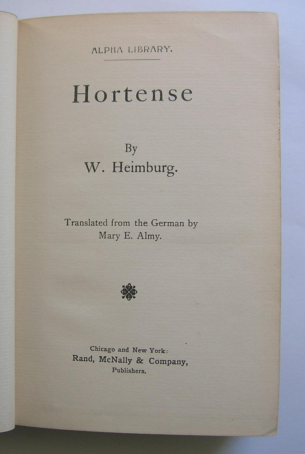
Heimburg, W. [Wilhelm]. Hortense.. Rand, McNally & Company, Publishers, Chicago and New York, 1891.
Price: US$5.00 + shipping
Condition: Fair
Description: Pseudonym of Bertha Behrens. Translated from the German by Mary E. Almy. Edges well worn, front hinge broken, some leaves loosening. Top edge gilt. Alpha Library. 336 pages, reading copy only. Green cloth, blind and gilt-stamped cover and spine.
Seller: Monkey House Books, Miller Place, NY, U.S.A.
Ryan, Marah Ellis. A Pagan of the Alleghanies. Rand, McNally, Chicago, 1891.
Price: US$7.00 + shipping
Condition: Good
Description: Brown cloth boards are rubbed on edges, lightly scuffed and mottled. spine tips chipping. Pages are clean, text has no markings, binding is sound. Size: 8vo - over 7¾" - 9¾" tall
Seller: Top Notch Books, Tolar, TX, U.S.A.
Royse, N.K.. A Study of Genius. Rand, McNally & Co., Chicago and New York, 1891.
Price: US$8.00 + shipping
Condition: Very Good
Description: Moderate wear to boards. Front flyleaf chipped at base with a narrow piece cut from its right side. Owner's nameplate at front endpaper. Tanning from newspaper clippings at pages 49, 50 and 51 with a few small shards still adhering to the inner margin not affecting text. Endpapers and flyleaves toned. Overall a clean and sound copy.
Seller: Alphaville Books, Inc., Hyattsville, MD, U.S.A.
Marah Ellis Ryan. A Pagan of the Alleghanies. Rand, McNally & Company, 1891.
Price: US$9.00 + shipping
Condition: Good
Description:
Seller: Books From California, Simi Valley, CA, U.S.A.
Heimburg, W.. Misjudged: A Novel. Rand, McNally, 1891.
Price: US$9.75 + shipping
Condition: Very Good
Description: 296pp; red cover with gilt lettering & decoration; top edge gilt, other edges uncut; laid paper; some darkening & wear to cover; prev. owner's name on free front endpage
Seller: THE OLD LIBRARY SHOP, Bethlehem, PA, U.S.A.
Ryan, Marah Ellis. A PAGAN OF THE ALLEGHANIES. Chicago: Rand, McNally, 1891, Chicago, IL, 1891.
Price: US$9.95 + shipping
Condition: Good
Description: Printed pictorial Boards. Good. First Edition. 8vo - over 7¾" - 9¾" tall. Address sticker on inside front cover. Size: 8vo - over 7¾" - 9¾" tall
Seller: Vashon Island Books, Vashon, WA, U.S.A.
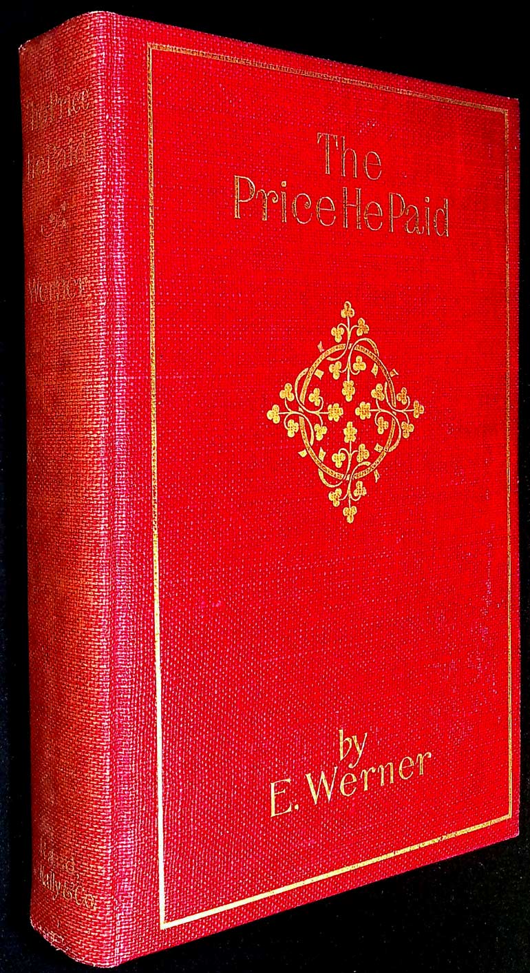
Werner, E.. The Price He Paid. Rand, McNally & Company, 1891.
Price: US$9.99 + shipping
Condition: Very Good
Description: No Stock Photos! We photograph every item. light edge wear, some fading to spine cloth, light soiling to page ends; red cloth with gilt lettering and designs, top edge gilt;
Seller: Kayleighbug Books, IOBA, Cedar Grove, WV, U.S.A.
W. Heimburg, W. ; Mary E. Almy, translator. Misjudged. Rand, Mcnally & Company, Chicago, 1891.
Price: US$10.00 + shipping
Condition: Very Good
Description: Green cloth hardback is tightly bound with no marks. Front cover is blind-stamped with gilt lettering at spine with very minor wear at cover edges. Back lower corner bumped. Tanning from age. Digital photos available. ; Small 8vo 7½" - 8" tall; 296 pages
Seller: The Book Lady, Lawrence, KS, U.S.A.
Ryan, Marah Ellis. A Pagan of the Alleghanies. Rand, McNally & Company, Chicago IL, 1891.
Price: US$10.00 + shipping
Condition: Fair
Description: Green cloth boards with gilding hing cracked at free end page; light soiling to page edges some foxing. A victorian fiction
Seller: OddReads, Harper, TX, U.S.A.
Price: US$10.53 + shipping
Condition: Fair
Description: Fair hardcover. No DJ. Text unmarked. Covers show edge wear with rubbing/soiling and bumped corners. Spine edge wear. Hinges cracked but binding still intact. Book shelf-cocked.; 100% Satisfaction Guaranteed! Ships same or next business day!
Seller: Redux Books, Grand Rapids, MI, U.S.A.

Royse, N.K.. A Study of Genius. Rand McNally, 1891.
Price: US$11.25 + shipping
Condition: Good
Description: 312 pages. Moderate wear to the green covers; pages are tanned with age; a couple page tears; name inside; a good old book overall. Illustrator: . Quantity Available: 1. Category: Psychology & Psychiatry; Inventory No: 196514.
Seller: Easy Chair Books, Lexington, MO, U.S.A.
Marah Ellis Ryan. A Pagan of the Alleghanies. Rand, McNally & Company, 1891.
Price: US$11.99 + shipping
Condition: Good
Description: Presumed first ed., perhaps later printing; frontis. photo-portrait of author 297 p., clean and unmarked anywhere but with mark on front end page where book plate may have been removed; paper strong but foxed; in absence of d.j. the unfaded green boards with beautiful Art Nouveau red and still-bright-gilt ornamentation have light bumping on corners and slight rubbing at crown and foot of spine; ink stains on back panel.
Seller: My Dead Aunt's Books, Hyattsville, MD, U.S.A.

W. Heimburg. Misjudged. Rand McNally, 1891.
Price: US$12.00 + shipping
Condition: Very Good
Description: Original red cloth covered boards with gilt lettering and design on cover and gilt lettering along spine; small bump along top edge. Binding and hinges tight and square; contents clean and unmarked except for owner signature on front inside cover. Gilt top edge. No dust jacket. 296pp. First Edition. All items carefully packed to avoid damage from moisture and rough handling.
Seller: Imperial Books and Collectibles, Wauwatosa, WI, U.S.A.
Ryan, Marah E. A PAGAN OF THE ALLEGHANIES. Rand McNally, Chicago, 1891.
Price: US$14.90 + shipping
Condition: Fine
Description: 297 pp., Blue Illus Hardback, Elaborate Blindstamped Gilt title on Spine & Front Cover, TEG, Fine & Crisp, no DJ, Assumed 1st ed (Beautiful Condition)
Seller: Larry W Price Books, Portland, OR, U.S.A.
W. Heimburg. Elsie. Rand McNally, Chicago, 1891.
Price: US$15.00 + shipping
Condition: Good
Description: Good copy. No jacket. In green cloth covers with red bands, lettering, and a magic lamp on front cover and red lettering on spine. Umarked, straight copy. Bumping of head and tail of spine and corners. Small stain on fore-edge. Light shelf rubbing. Size: 12mo - over 6¾" - 7¾" tall
Seller: Quaker House Books, Catawissa, PA, U.S.A.
Werner, E. The Price he Paid. Rand, McNally & Co., Chicago, 1891.
Price: US$18.00 + shipping
Condition: Good
Description: 307 pages; 23 chapters; Pages tight; slight yellowing; previous owner name on book label pasted on front inside cover. Page edges somewhat foxed; Green hard covers with gild lettering on front and spine. Ornate border and design etched on front cover. Minor shelf wear; VERY RARE VINTAGE COVER.
Seller: Attic Treasures Book Shop, Mt. Carmel, IL, U.S.A.
Heimburg, W.. Hortense. Rand McNally, Chicago, 1891.
Price: US$19.75 + shipping
Condition: Very Good
Description: Tan boards with nice decrotive binding. Boards have wear on edges - particularly on spine ends and corners. Book is clean, square and tight. Top edge gilt. 336 pgs.
Seller: Wellfleet Books, Wellfleet, MA, U.S.A.
Ryan, Marah Ellis. A PAGAN OF THE ALLEGHANIES. Rand, McNally & Co., 1891.
Price: US$19.95 + shipping
Condition: Very Good
Description: Small 8vo 7½" - 8" ; 297 pages
Seller: The Story Shop, Elwood, IN, U.S.A.
Ludovic Halevy. A Marriage For Love. Rand, McNally & Company, Chicago & NY, 1891.
Price: US$20.00 + shipping
Condition: Good
Description: 106 pp + 8 pads, the book and contents are tight, the pages are browned and the first page , an advertisement, has a 1" x 1.25" chip out of the side, the top right corner of the pages has a 3/16" chip off the corner of approximately half the pages, the covers are tight and have some light wear and soil.
Seller: Yesterday's Books, Richmond, IN, U.S.A.
Heimburg, W.. Elsie. Rand, Mcnally & Co, 1891.
Price: US$22.50 + shipping
Condition: Good
Description: Book is in good condition, clean and crisp pages, solid binding; slightly cocked, medium/heavy wear to spine edges and corner tips, light wear to covers, discoloration to page edges, 2 inch closed tear on page 49/50. Overall, book is in good condition for its age.
Seller: Recycle Bookstore, San Jose, CA, U.S.A.
Heimburg, W.. HORTENSE. Rand, McNally & Company, Chicago, 1891.
Price: US$22.50 + shipping
Condition: Very Good
Description: Two color decorated binding (Maroon & Gold) and top-edge is gilt. Very good condition with a hint of shelfwear. 336 pages. Size: 12mo - over 6¾" - 7¾" tall
Seller: Bertram Books And Fine Art, West Point, VA, U.S.A.
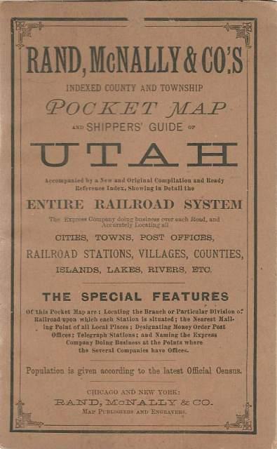
Price: US$22.50 + shipping
Condition: Good
Description: Rand, McNally & Co., 1891. Good. , Softbound, Guide only, no map. 16 pages followed by ads. Light wear to cover corners. Pages tanned. Several small abrasions on rear cover. Out-of-print and antiquarian booksellers since 1933. We pack and ship with care.
Seller: Lincbook, Foster, RI, U.S.A.

Price: US$24.00 + shipping
Condition: Poor
Description: Cover Only For A Railroad Brochure, Printed By Rand Mcnally, Where Bradley Had Been Employed As A Shop Assistant Circa 1887. From A Very Large And Sophisticated Collection Of Bradley Material, Not Signed By Bradley But Illustration Apparently By Him.
Seller: Arroyo Seco Books, Pasadena, Member IOBA, Pasadena, CA, U.S.A.
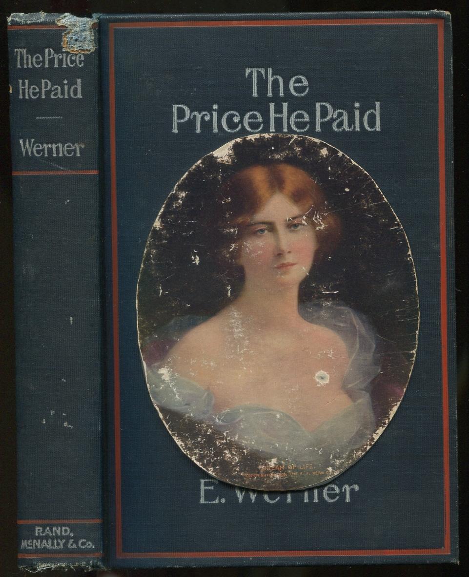
WERNER, E.. The Price He Paid. Rand, McNally & Company, Chicago, 1891.
Price: US$25.00 + shipping
Condition: Near Fine
Description: Pictorial blue cloth stamped in red and white with color portrait mounted on front, top edge gilt. Owner's name penned on front fly, hinges starting with spine cocked, spine ends chipped, front cover portrait rubbed, else very good. Alpha Library series.
Seller: Between the Covers-Rare Books, Inc. ABAA, Gloucester City, NJ, U.S.A.

Heimburg, W.. Elsie. Rand McNally & Company, Chicago and New York, 1891.
Price: US$26.00 + shipping
Condition: Good
Description: Translated by Hettie E. Miller. Owner label and name on front end page, red cloth, gilt decor and lettering, shelf wear. S4 2
Seller: COVENANT HERITAGE LIBRIS, Saint John, NB, Canada
Barrie, J. M.. Better Dead. Rand, McNally & Co., Chicago & New York, 1891.
Price: US$27.50 + shipping
Condition: Poor
Description: Paper covers are detached and rubbed but present. Front cover has slight damp staining to the area of the lower spine corner. Spine is missing the top spine end and is creased. Title page is detached and missing large pieces, but lettering is complete except "Etc." following "Author of ." . Front ads are detached and incomplete. Rear ads are detached and chipped. Binding is very loose in general and some leaves in rear are detached but present. Pages are slightly browned, some are missing the upper outer corners. ; Issued as Globe Library, Vol. I, No. 165. In a custom protective case. ; 150 pages
Seller: Willis Monie-Books, ABAA, Cooperstown, NY, U.S.A.
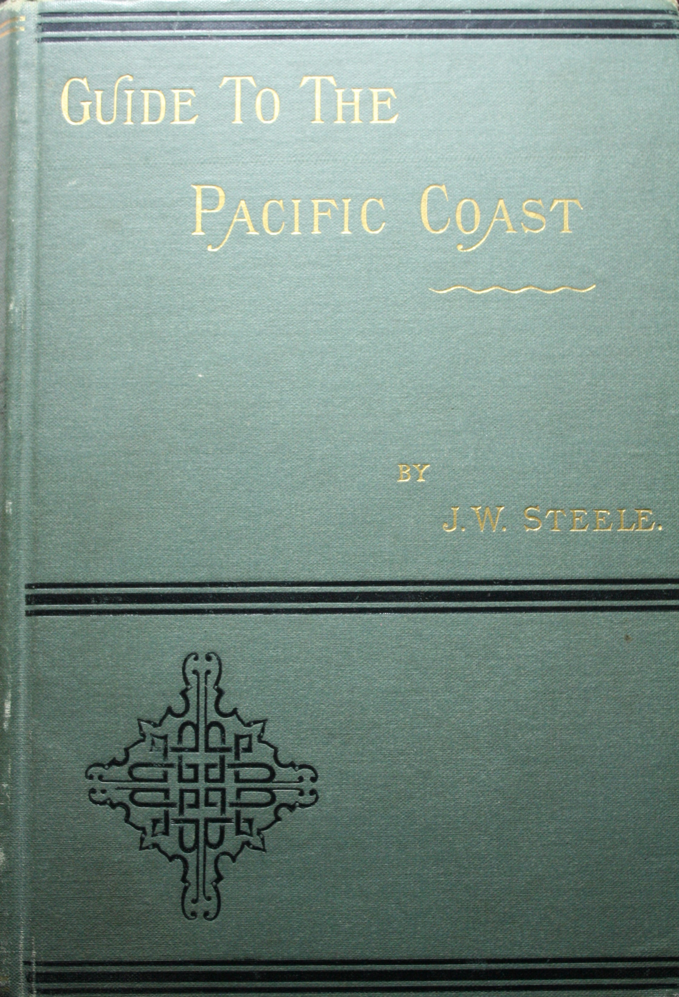
Steele, J.W.. New Guide to the Pacific Coast. Rand McNally, 1891.
Price: US$30.00 + shipping
Condition: Very Good
Description: IN green cloth. Fold-out map has some wear.
Seller: Jay W. Nelson, Bookseller, IOBA, Austin, MN, U.S.A.

Price: US$30.00 + shipping
Condition: Very Good
Description: Rand, McNally & Co., 1891. Very good. , Softbound, Brown wrappers. 56 pages plus several ad pages at rear. Map is detached from inside rear cover. Pages are tanned. Out-of-print and antiquarian booksellers since 1933. We pack and ship with care.
Seller: Lincbook, Foster, RI, U.S.A.
Price: US$32.35 + shipping
Condition: Near Fine
Description: A nice copy of the true first edition, first printing (1891), inscribed and dated (May, 1916) by the author to the front fly-leaf. Text is solid, clean, and tight. Lettering to front board and spine is bright and unflaked. No marks or highlights in text. Small faded spot to front board, short closed tear to front endpaper top edge, mild wear to spine ends. No previous owner's names. Not ex-lib. Not a Book Club Edition. Photos sent upon request. Accurate Descriptions/Quality Books/Unmatched Prices
Seller: Novel Ending Books, Franklin, TN, U.S.A.

. RAND, McNALLY & CO'S PICTORIAL GUIDE TO CHICAGO. RAND, McNALLY & CO, CHICAGO, 1891.
Price: US$33.35 + shipping
Condition: Very Good
Description: SOFT BOUND IN THE ORIGINAL CARD COVERS, NUMEROUS ILLUSTRATIONS THAT ARE FULL PAGE OR AMONG TEXT, SEVERAL ADVERT PAGES TO REAR, DETAILED STREET & AVENUE INDEX TO REAR. BOOK MEASURES APPROX 7 X 4.5 INCHES WITH 116 PAGES. LACKING A SMALL FOLDING MAP, FEW MINOR CREASES & MARKS TO COVER, MINOR CHIPPING AT TOP & BOTTOM OF SPINE, OCCASIONAL MINOR MARK TO PAGES. OVERALL A VERY GOOD COPY WITH COVERS WELL ATTACHED. EXTRA POSTAGE MAY APPLY FOR OVERSEAS ORDERS. ALL BOOKS ARE POSTED IN A STURDY BOOK BOX.
Seller: Elder Books, Ross on Wye, Herefordshire, United Kingdom
Price: US$35.00 + shipping
Condition: Very Good
Description: Original cloth, 212 pages + ads, illustrations, front hinge cracked, small railroad stamp and a 1894 owner name, wear to edges, fold-out map.
Seller: Old West Books (ABAA), St. Robert, MO, U.S.A.
Reynolds, D A. Wolverton or The Modern Arena. Rand McNally & Co, Chicago, IL, 1891.
Price: US$38.00 + shipping
Condition: Good
Description: Good (top & bottom of spine is worn a little) -- Email for Pictures
Seller: Pepper's Old Books, Hanson, KY, U.S.A.

LOTI PIERRE, By M. L. WATKINS. THE ROMANCE OF A CHILD. Rand, McNally & Co., 1891.
Price: US$39.34 + shipping
Condition: Near Fine
Description: RO40239627: 1891. In-12. Broché. Etat d'usage, Plats abîmés, Dos satisfaisant, Intérieur acceptable. 179 pages. Text in English. Papier muet encollé sur le dos, le consolidant. Etiquette de code sur le dos. Tampons et annotations de bibliothèque sur le 1er plat et en page de titre. Petits manques sur les plats. Couverture se détachant. Page de titra tachée et abîmée. Quelques annotations au crayon dans le texte en début d'ouvrage. Pages légèrement jaunies. . . . Classification Dewey : 420-Langue anglaise. Anglo-saxon
Seller: Le-Livre, SABLONS, France

Price: US$40.00 + shipping
Description: This very unusual map, from the German edition of Rand McNally and Co.s "New Family Atlas of the World" ("Neuer Familien Atlas der Welt") was produced in 1891. The map has English text, but text and titles in margin are in German. Map has light pastel coloring and identifies counties, roads, railroads, important cities and land-forms. Inset map shows Iceland. This map measures 12.5 inches by 9.5 inches.
Seller: Art Source International Inc., Boulder, CO, U.S.A.
Price: US$45.00 + shipping
Condition: Good
Description: 312 pp; Covers are soiled and edge worn at the spine ends and corners, front inner hinge cracked and holding by the binders webbing, pages age toned, a few pages soiled but most are fine. Back cover has a whitish stain on 2 inches of the corner. Previous owners name. There is a good bit of wear to the binding but it is still a nice book
Seller: GLOVER'S BOOKERY, ABAA, Lexington, KY, U.S.A.
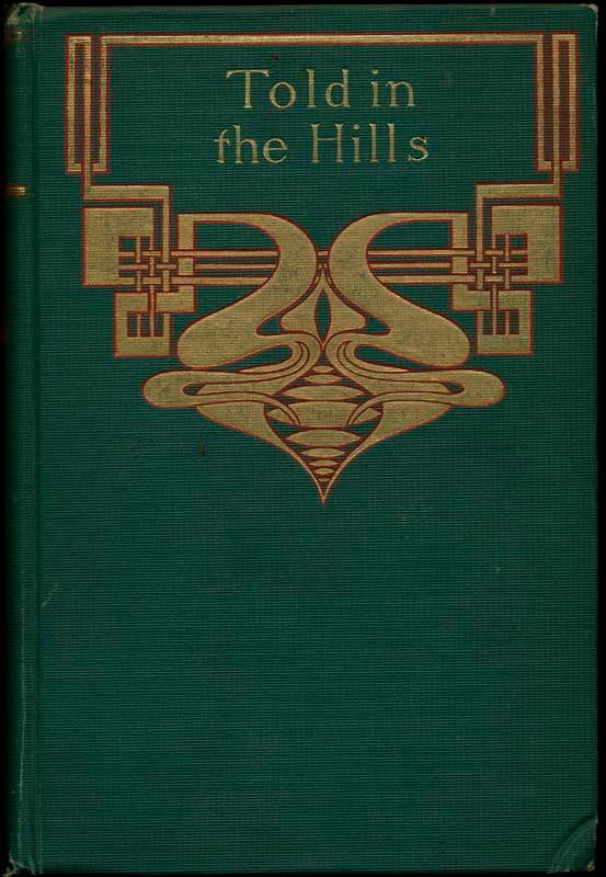
RYAN, Marah Ellis. Told in the Hills. Rand, McNally & Company, Chicago, 1891.
Price: US$45.00 + shipping
Description: Smal 8vo. Green cloth and decorative red and gold gilt. 362pp. Very good. Very minor shelfwear; non-authorial gift inscription on inner flyleaf. Early (apparently not first) printing, tight and attractive, of this minor classic.
Seller: Main Street Fine Books & Mss, ABAA, Galena, IL, U.S.A.
Ryan, Marah Ellis.. A PAGAN OF THE ALLEGHANIES.. Rand, McNally & Co., Chicago & NY: (1891)., 1891.
Price: US$45.00 + shipping
Condition: Good
Description: 297 p. Portrait Frontis. 8vo. Original decorated publisher's cloth. Spine worn & soiled. Text block cocked. Scarce. PA 36 Language: eng
Seller: FAMILY ALBUM, Kinzers, PA, U.S.A.
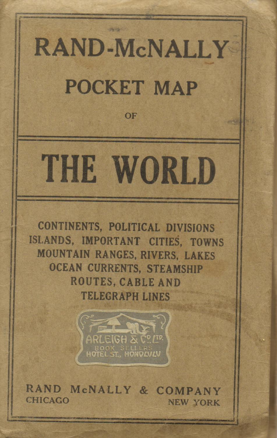
. Rand Mcnally Pocket Map of the World. Rand McNally & Company, Chicago And New York, 1891.
Price: US$45.00 + shipping
Condition: Very Good
Description: A color folding map measuring 22" x 28". These pocket maps are hard to find in good condition. A few foxed spots and one-inch tears on map. Brown wrappers have soil and creased edges, with an old Honolulu bookseller's label on the front. Continents, political divisions, islands, important cities, towns, mountain ranges, rivers, lakes, ocean currents, steamship routes, cable and telegraph lines. ; 6 1/4" x 4 1/4"
Seller: Back of Beyond Books, Moab, UT, U.S.A.

Rand McNally & Co.. Brazil. , 1891.
Price: US$45.00 + shipping
Description: This very unusual map, from the German edition of Rand McNally and Co.s "New Family Atlas of the World" ("Neuer Familien Atlas der Welt") was produced in 1891. The map has English text, but text and titles in margin are in German. Map has light pastel coloring and identifies counties, roads, railroads, important cities and land-forms. Inset map shows the upper Amazon River. This map measures 12.5 inches by 9.5 inches.
Seller: Art Source International Inc., Boulder, CO, U.S.A.
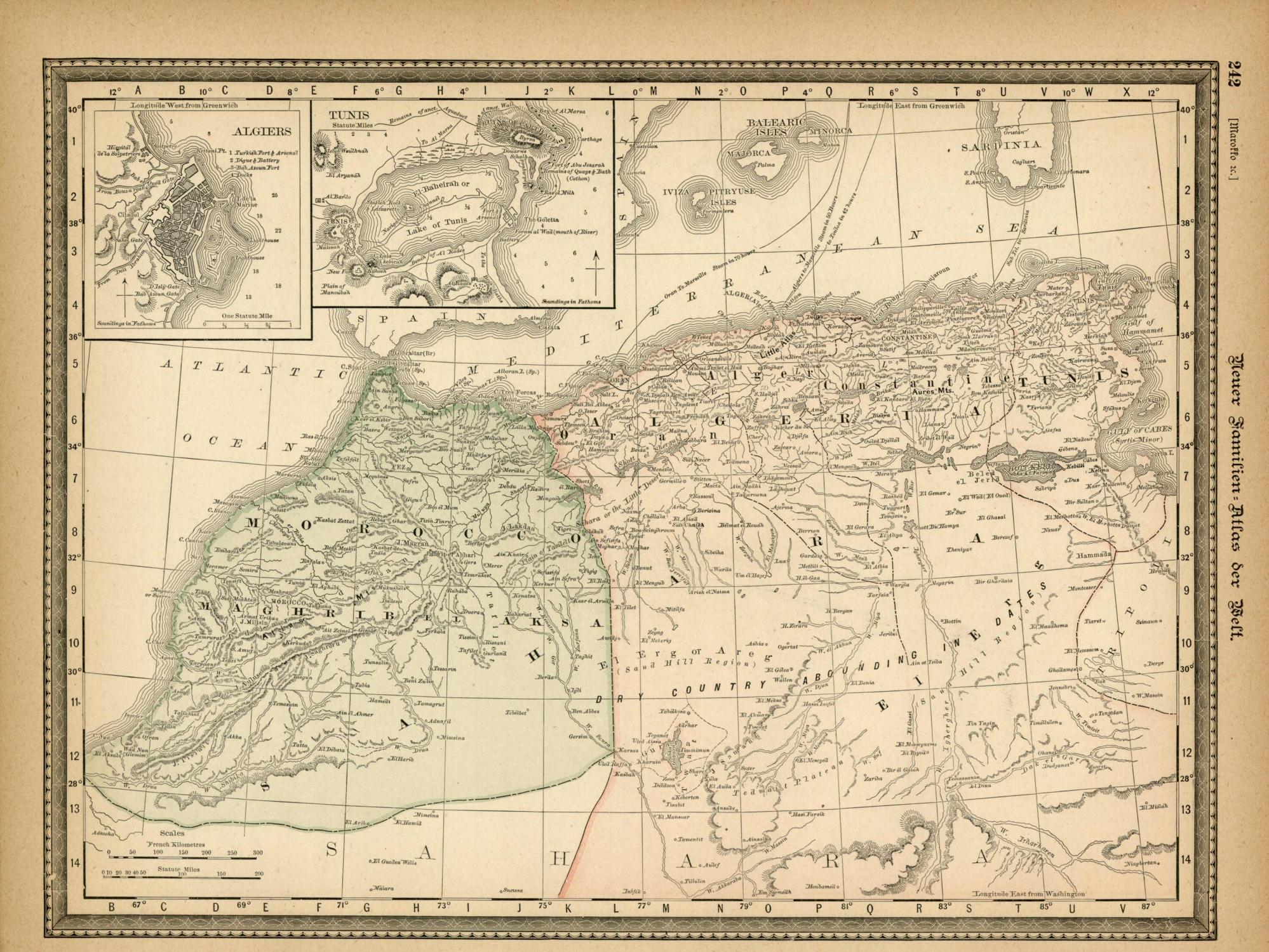
Rand McNally & Co.. Marocco & Algeria. , 1891.
Price: US$45.00 + shipping
Description: This very unusual map, from the German edition of Rand McNally and Co.s "New Family Atlas of the World" ("Neuer Familien Atlas der Welt") was produced in 1891. The map has English text, but text and titles in margin are in German. Map has light pastel coloring and identifies counties, roads, railroads, important cities and land-forms. Inset maps show Algiers and Tunis. This map measures 9.5 inches by 12.5 inches.
Seller: Art Source International Inc., Boulder, CO, U.S.A.

Rand McNally & Co.. Northwestern Portion of South America. , 1891.
Price: US$45.00 + shipping
Description: This very unusual map, from the German edition of Rand McNally and Co.s "New Family Atlas of the World" ("Neuer Familien Atlas der Welt") was produced in 1891. The map has English text, but text and titles in margin are in German. Map has light pastel coloring and identifies counties, roads, railroads, important cities and land-forms. This map measures 12.5 inches by 9.5 inches.
Seller: Art Source International Inc., Boulder, CO, U.S.A.
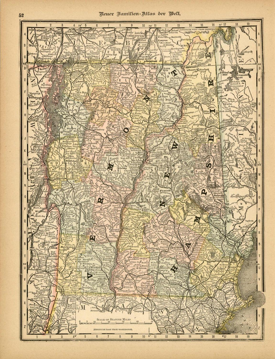
Rand McNally & Co.. Vermont & New Hampshire. , 1891.
Price: US$45.00 + shipping
Description: This very unusual map, from the German edition of Rand McNally and Co.s "New Family Atlas of the World" ("Neuer Familien Atlas der Welt") was produced in 1891. The map has English text, but text and titles in margin are in German. Map has light pastel coloring and identifies counties, roads, railroads, important cities and land-forms. This map measures 12.5 inches by 9.5 inches.
Seller: Art Source International Inc., Boulder, CO, U.S.A.
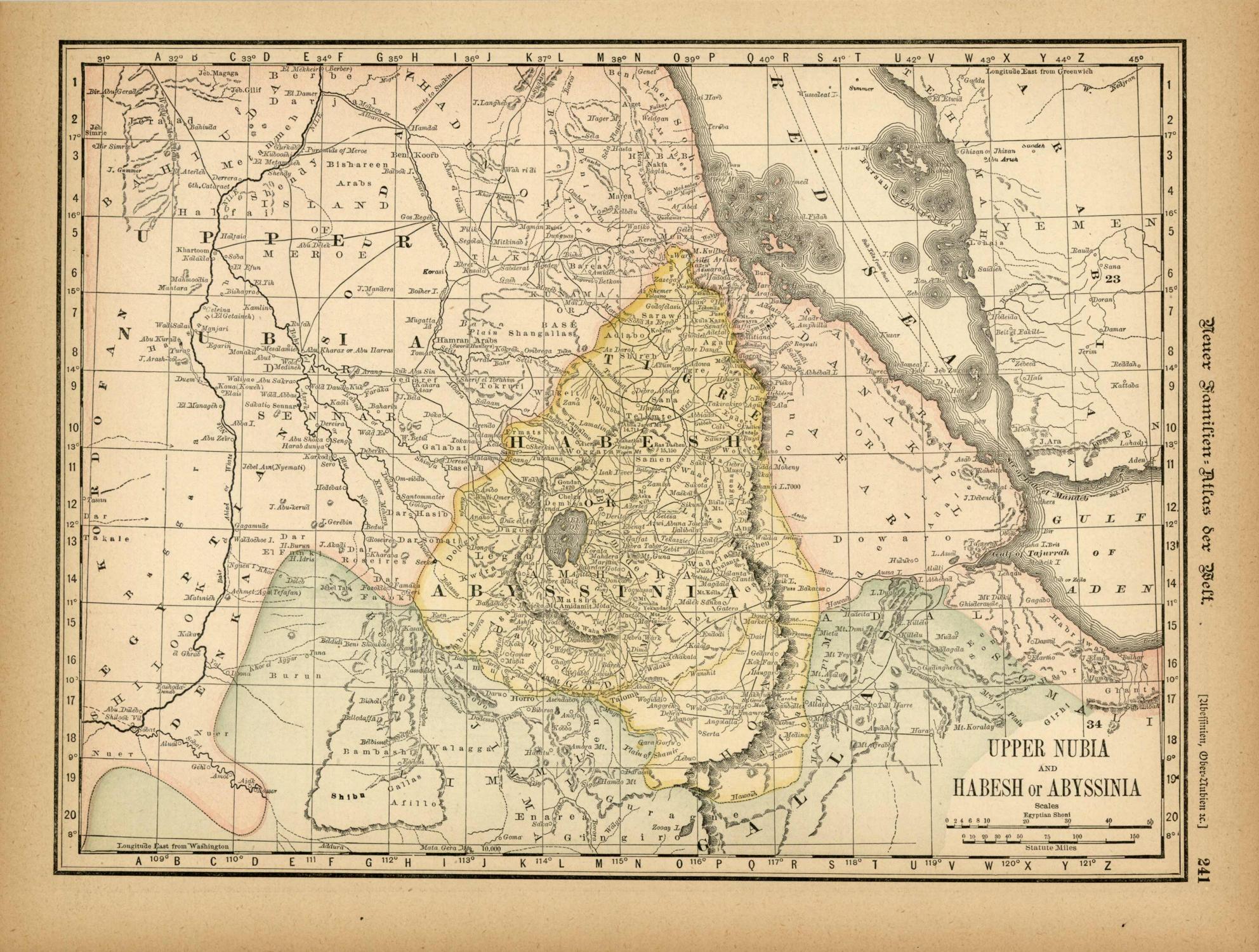
Rand McNally & Co.. Upper Nubia and Habesh or Abyssinia. , 1891.
Price: US$45.00 + shipping
Description: This very unusual map, from the German edition of Rand McNally and Co.s "New Family Atlas of the World" ("Neuer Familien Atlas der Welt") was produced in 1891. The map has English text, but text and titles in margin are in German. Map has light pastel coloring and identifies counties, roads, railroads, important cities and land-forms. This map measures 9.5 inches by 12.5 inches.
Seller: Art Source International Inc., Boulder, CO, U.S.A.

Rand McNally & Co.. McNally's 1891 Map of Europe. , 1891.
Price: US$45.00 + shipping
Description: We are proud to offer this map of Europe, originally produced as part of Rand McNally's Enlarged Business Atlas dated 1891. Although the table of contents shows different editions starting in 1885, we believe this is the first edition of the Enlarged Atlas. Each of these maps accurately locates all cities, towns, post offices, railroad stations, villages, counties, parishes, islands, lakes, rivers, mountains and more. Until McNallyâs enlarged Business Atlas, maps had never been produced that provided as much information as these do. Even today, we use these 130 year old maps to locate small towns, villages, and railroad routes that are no more.The size of the map is 19.75 x 13.25
Seller: Art Source International Inc., Boulder, CO, U.S.A.

Kipling, Rudyard. The Light That Failed. Rand McNally, NY, 1891.
Price: US$49.99 + shipping
Condition: Very Good
Description: Cloth with spine label. Reprint. Later cloth? Ad page at front nearly detached; pages toned. The label has faded, and typed title has been affixed to label. ; 8vo 8" - 9" tall; 219,[20] ads pages
Seller: curtis paul books, inc., Northridge, CA, U.S.A.

Rand McNally & Co.. Utah. , 1891.
Price: US$50.00 + shipping
Description: This very unusual map, from the German edition of Rand McNally and Co.s "New Family Atlas of the World" ("Neuer Familien Atlas der Welt") was produced in 1891. The map has English text, but text and titles in margin are in German. Map has light pastel coloring and identifies counties, roads, railroads, important cities and land-forms. This map measures 12.5 inches by 9.5 inches.
Seller: Art Source International Inc., Boulder, CO, U.S.A.

Rand McNally. Rhode Island. , 1891.
Price: US$50.00 + shipping
Description: This very unusual map, from the German edition of Rand McNally and Co.s "New Family Atlas of the World" ("Neuer Familien Atlas der Welt") was produced in 1891. The map has English text, but text and titles in margin are in German. Map has light pastel coloring and identifies counties, roads, railroads, important cities and land-forms. Inset map shows City of Providence.The size of the map is 9.5 x 12.5
Seller: Art Source International Inc., Boulder, CO, U.S.A.

Rand, McNally & Company. McNally's 1891 Map of North Dakota. , 1891.
Price: US$50.00 + shipping
Description: We are proud to offer this map of North Dakota, originally produced as part of Rand McNally's Enlarged Business Atlas dated 1891. Although the table of contents shows different editions starting in 1885, we believe this is the first edition of the Enlarged Atlas. Each of these maps accurately locates all cities, towns, post offices, railroad stations, villages, counties, parishes, islands, lakes, rivers, mountains and more. Until McNallyâs enlarged Business Atlas, maps had never been produced that provided as much information as these do. Even today, we use these 130 year old maps to locate small towns, villages, and railroad routes that are no more. This map measures 13.5 inches by 22.25 inches.
Seller: Art Source International Inc., Boulder, CO, U.S.A.

Rand, McNally & Company. McNally's 1891 Map of Maine. , 1891.
Price: US$50.00 + shipping
Description: We are proud to offer this map of Maine, originally produced as part of Rand McNally's Enlarged Business Atlas, dated 1891. Although the table of contents shows different editions starting in 1885, we believe this is the first edition of the Enlarged Atlas. Each of these maps accurately locates all cities, towns, post offices, railroad stations, villages, counties, parishes, islands, lakes, rivers, mountains and more. Until McNallyâs enlarged Business Atlas, maps had never been produced that provided as much information as these do. Even today, we use these 130 year old maps to locate small towns, villages, and railroad routes that are no more. This map measures 18.75 inches by 13.25 inches.
Seller: Art Source International Inc., Boulder, CO, U.S.A.
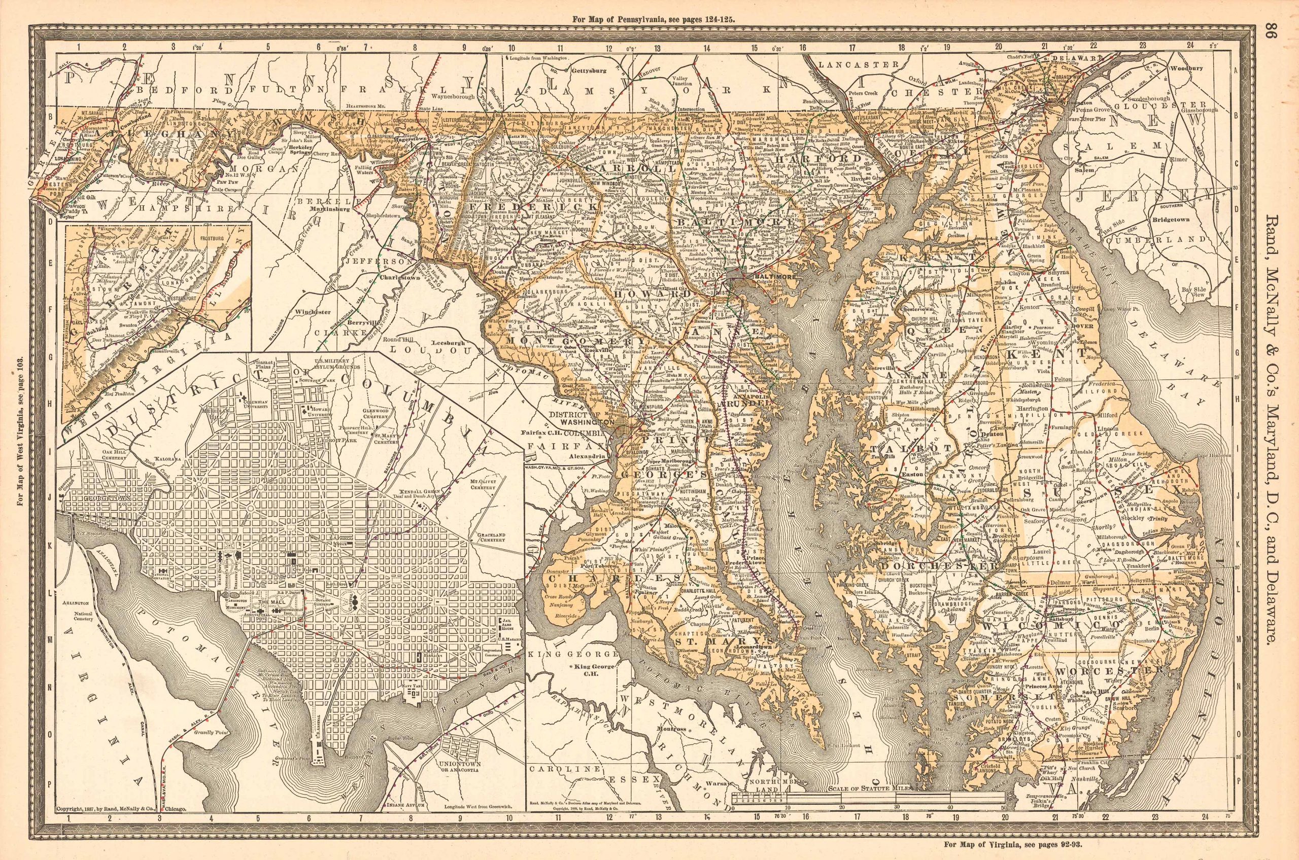
Rand, McNally & Company. McNally's 1891 Map of Maryland, D.C. and Delaware. , 1891.
Price: US$50.00 + shipping
Description: We are proud to offer this map of Maryland, D.C. and Delaware, originally produced as part of Rand McNally's Enlarged Business Atlas dated 1891. Although the table of contents shows different editions starting in 1885, we believe this is the first edition of the Enlarged Atlas. Each of these maps accurately locates all cities, towns, post offices, railroad stations, villages, counties, parishes, islands, lakes, rivers, mountains and more. Until McNallyâs enlarged Business Atlas, maps had never been produced that provided as much information as these do. Even today, we use these 130 year old maps to locate small towns, villages, and railroad routes that are no more. This map measures 13.25 inches by 19.75 inches.
Seller: Art Source International Inc., Boulder, CO, U.S.A.

Rand, McNally & Company. McNally's 1891 Map of Ohio. , 1891.
Price: US$50.00 + shipping
Description: We are proud to offer this map of Ohio, originally produced as part of Rand McNally's Enlarged Business Atlas dated 1891. Although the table of contents shows different editions starting in 1885, we believe this is the first edition of the Enlarged Atlas. Each of these maps accurately locates all cities, towns, post offices, railroad stations, villages, counties, parishes, islands, lakes, rivers, mountains and more. Until McNallyâs enlarged Business Atlas, maps had never been produced that provided as much information as these do. Even today, we use these 130 year old maps to locate small towns, villages, and railroad routes that are no more. This map measures 26 inches by 19 inches.
Seller: Art Source International Inc., Boulder, CO, U.S.A.
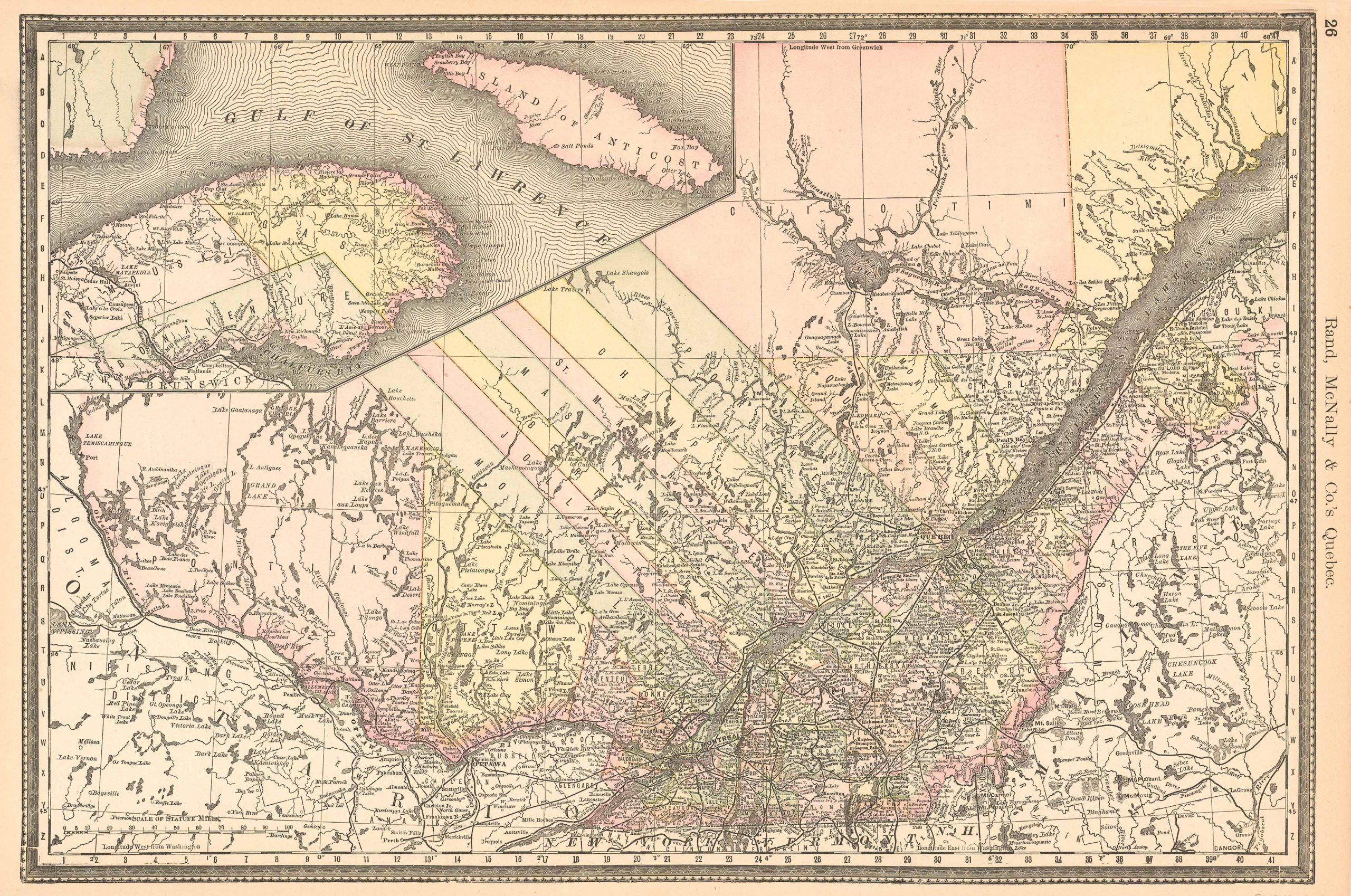
Rand, McNally & Company. McNally's 1891 Map of Quebec. , 1891.
Price: US$50.00 + shipping
Description: We are proud to offer this map of Quebec, originally produced as part of Rand McNally's Enlarged Business Atlas dated 1891. Although the table of contents shows different editions starting in 1885, we believe this is the first edition of the Enlarged Atlas. Each of these maps accurately locates all cities, towns, post offices, railroad stations, villages, counties, parishes, islands, lakes, rivers, mountains and more. Until McNallyâs enlarged Business Atlas, maps had never been produced that provided as much information as these do. Even today, we use these 130 year old maps to locate small towns, villages, and railroad routes that are no more. This map measures 13.75 inches by 19.75 inches.
Seller: Art Source International Inc., Boulder, CO, U.S.A.

Rand, McNally & Company. McNally's 1891 Map of Africa. , 1891.
Price: US$50.00 + shipping
Description: We are proud to offer this map of Africa, originally produced as part of Rand McNally's Enlarged Business Atlas dated 1891. Although the table of contents shows different editions starting in 1885, we believe this is the first edition of the Enlarged Atlas. Each of these maps accurately locates all cities, towns, post offices, railroad stations, villages, counties, parishes, islands, lakes, rivers, mountains and more. Until McNallyâs enlarged Business Atlas, maps had never been produced that provided as much information as these do. Even today, we use these 130 year old maps to locate small towns, villages, and railroad routes that are no more. This map measures 13.25 inches by 9.5 inches.
Seller: Art Source International Inc., Boulder, CO, U.S.A.

Price: US$50.00 + shipping
Description: We are proud to offer this map of the Southern Portion of South America and Brazil, Paraguay and Guayana, originally produced as part of Rand McNally's Enlarged Business Atlas dated 1891. Although the table of contents shows different editions starting in 1885, we believe this is the first edition of the Enlarged Atlas. Each of these maps accurately locates all cities, towns, post offices, railroad stations, villages, counties, parishes, islands, lakes, rivers, mountains and more. Until McNallyâs enlarged Business Atlas, maps had never been produced that provided as much information as these do. Even today, we use these 130 year old maps to locate small towns, villages, and railroad routes that are no more.The size of the map is 19.75 x 13.25
Seller: Art Source International Inc., Boulder, CO, U.S.A.

Rand, McNally & Company. McNally's 1891 Map of Vermont. , 1891.
Price: US$50.00 + shipping
Description: We are proud to offer this map of Vermont, originally produced as part of Rand McNally's Enlarged Business Atlas dated 1891. Although the table of contents shows different editions starting in 1885, we believe this is the first edition of the Enlarged Atlas. Each of these maps accurately locates all cities, towns, post offices, railroad stations, villages, counties, parishes, islands, lakes, rivers, mountains and more. Until McNallyâs enlarged Business Atlas, maps had never been produced that provided as much information as these do. Even today, we use these 130 year old maps to locate small towns, villages, and railroad routes that are no more. This map measures 19.75 inches by 13.75 inches.
Seller: Art Source International Inc., Boulder, CO, U.S.A.
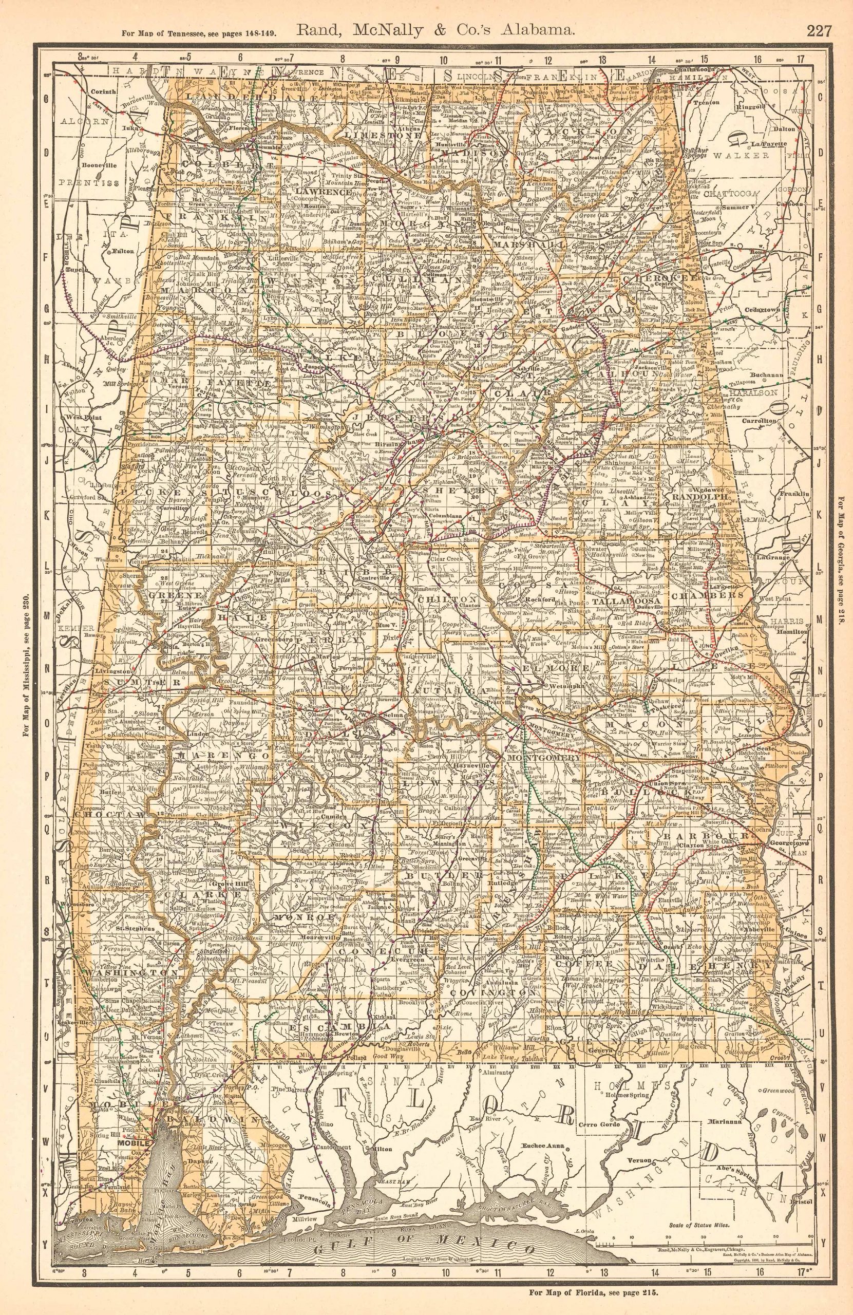
Rand, McNally & Company. McNally's 1891 Map of Alabama. , 1891.
Price: US$50.00 + shipping
Description: We are proud to offer this map of Alabama, originally produced as part of Rand McNally's Enlarged Business Atlas dated 1891. Although the table of contents shows different editions starting in 1885, we believe this is the first edition of the Enlarged Atlas. Each of these maps accurately locates all cities, towns, post offices, railroad stations, villages, counties, parishes, islands, lakes, rivers, mountains and more. Until McNallyâs enlarged Business Atlas, maps had never been produced that provided as much information as these do. Even today, we use these 130 year old maps to locate small towns, villages, and railroad routes that are no more.The map measures 13.25 by 19.75 inches.
Seller: Art Source International Inc., Boulder, CO, U.S.A.
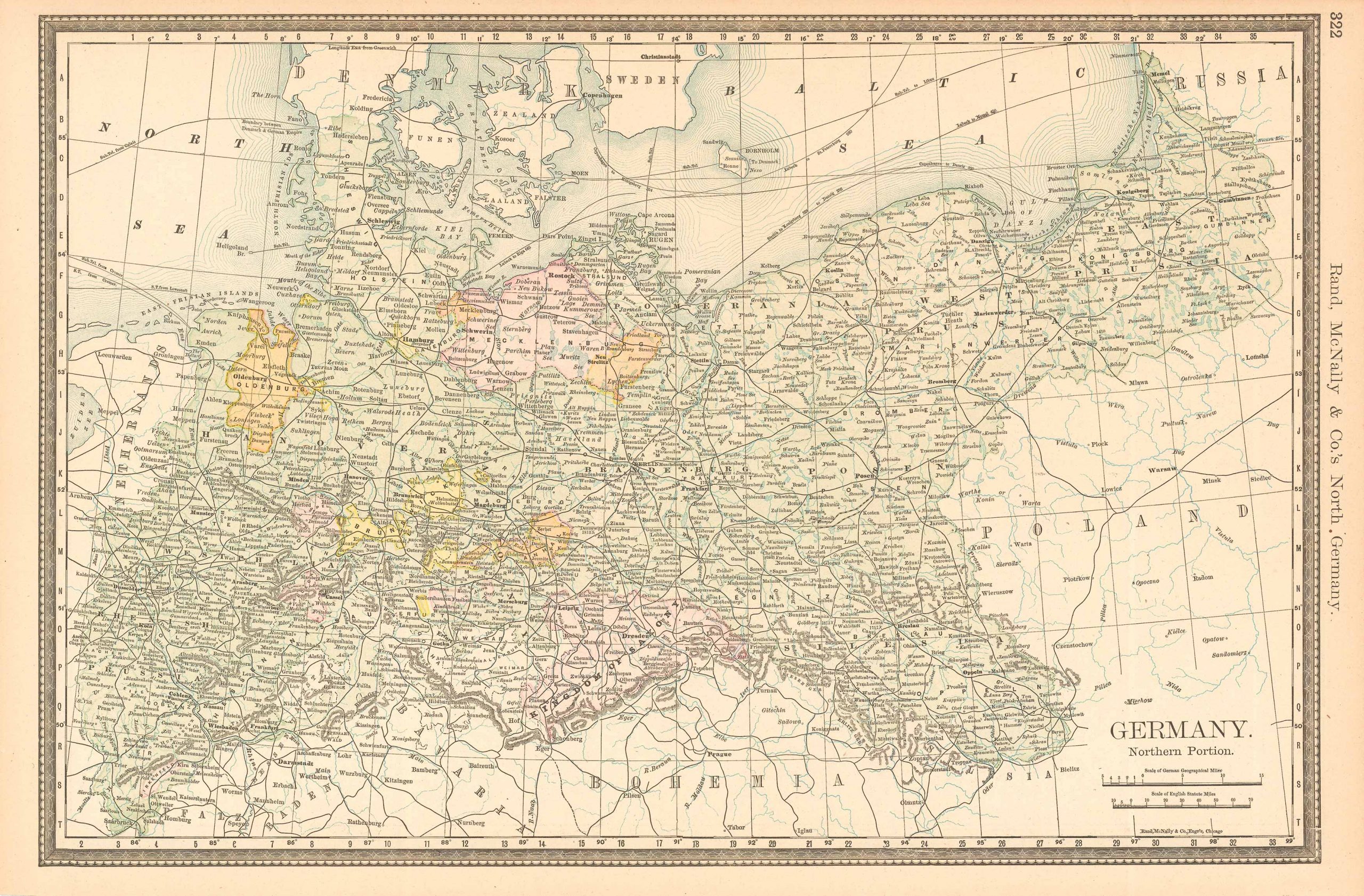
Rand, McNally & Company. McNally's 1891 Map of Germany, Northern Portion. , 1891.
Price: US$50.00 + shipping
Description: We are proud to offer this map of Germany Northern Portion, originally produced as part of Rand McNally's Enlarged Business Atlas dated 1891. Although the table of contents shows different editions starting in 1885, we believe this is the first edition of the Enlarged Atlas. Each of these maps accurately locates all cities, towns, post offices, railroad stations, villages, counties, parishes, islands, lakes, rivers, mountains and more. Until McNallyâs enlarged Business Atlas, maps had never been produced that provided as much information as these do. Even today, we use these 130 year old maps to locate small towns, villages, and railroad routes that are no more. This map measures 13.25 inches by 19.75 inches.
Seller: Art Source International Inc., Boulder, CO, U.S.A.

Rand, McNally & Company. McNally's 1891 Map of Massachusetts. , 1891.
Price: US$50.00 + shipping
Description: We are proud to offer this map of Massachusetts, originally produced as part of Rand McNally's Enlarged Business Atlas, dated 1891. Although the table of contents shows different editions starting in 1885, we believe this is the first edition of the Enlarged Atlas. Each of these maps accurately locates all cities, towns, post offices, railroad stations, villages, counties, parishes, islands, lakes, rivers, mountains and more. Until McNallyâs enlarged Business Atlas, maps had never been produced that provided as much information as these do. Even today, we use these 130 year old maps to locate small towns, villages, and railroad routes that are no more. This map measures 19 inches by 26 inches.
Seller: Art Source International Inc., Boulder, CO, U.S.A.

Rand, McNally & Company. McNally's 1891 Map of Ontario No. 2. , 1891.
Price: US$50.00 + shipping
Description: We are proud to offer this map of Ontario No.2, originally produced as part of Rand McNally's Enlarged Business Atlas dated 1891. Although the table of contents shows different editions starting in 1885, we believe this is the first edition of the Enlarged Atlas. Each of these maps accurately locates all cities, towns, post offices, railroad stations, villages, counties, parishes, islands, lakes, rivers, mountains and more. Until McNallyâs enlarged Business Atlas, maps had never been produced that provided as much information as these do. Even today, we use these 130 year old maps to locate small towns, villages, and railroad routes that are no more. This map measures 13.25 inches by 19.75 inches.
Seller: Art Source International Inc., Boulder, CO, U.S.A.
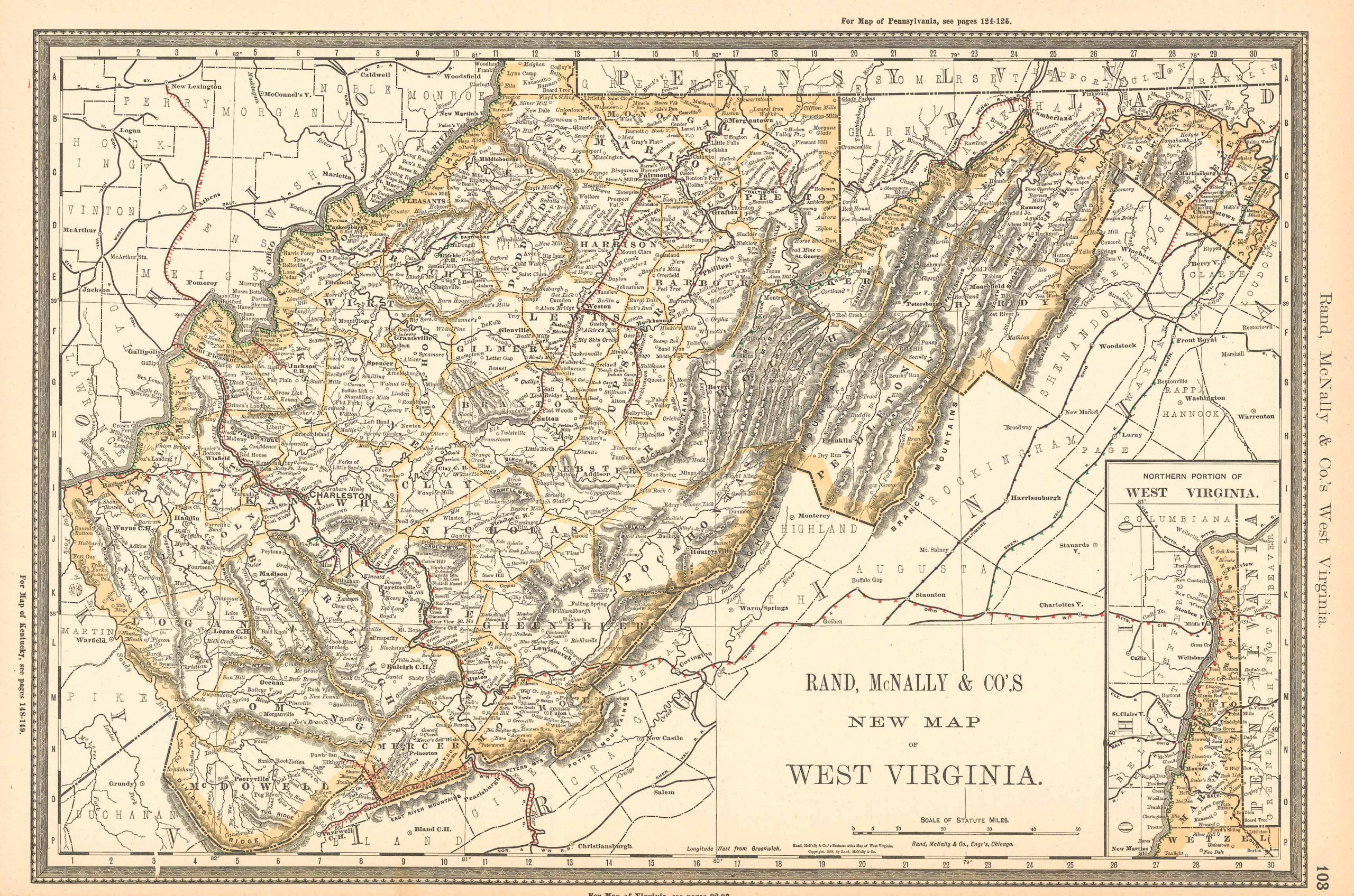
Rand McNally & Co.. McNally's 1891 New Map of West Virginia. , 1891.
Price: US$50.00 + shipping
Description: We are proud to offer this map of West Virginia, originally produced as part of Rand McNally's Enlarged Business Atlas dated 1891. Although the table of contents shows different editions starting in 1885, we believe this is the first edition of the Enlarged Atlas. Each of these maps accurately locates all cities, towns, post offices, railroad stations, villages, counties, parishes, islands, lakes, rivers, mountains and more. Until McNallyâs enlarged Business Atlas, maps had never been produced that provided as much information as these do. Even today, we use these 130 year old maps to locate small towns, villages, and railroad routes that are no more.The map measures 19.75 by 13.25 inches.
Seller: Art Source International Inc., Boulder, CO, U.S.A.
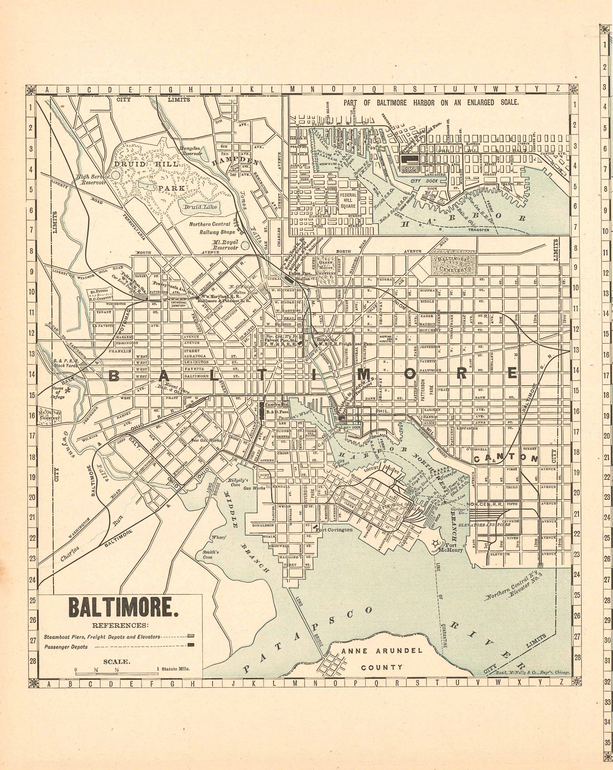
Rand, McNally & Company. McNally's 1891 Map of Baltimore. , 1891.
Price: US$50.00 + shipping
Description: We are proud to offer this map of Baltimore, originally produced as part of Rand McNally's Enlarged Business Atlas dated 1891. Although the table of contents shows different editions starting in 1885, we believe this is the first edition of the Enlarged Atlas. Each of these maps accurately locates all cities, towns, post offices, railroad stations, villages, counties, parishes, islands, lakes, rivers, mountains and more. Until McNallyâs enlarged Business Atlas, maps had never been produced that provided as much information as these do. Even today, we use these 130 year old maps to locate small towns, villages, and railroad routes that are no more. This map measures 10.25 inches by 9.5 inches.
Seller: Art Source International Inc., Boulder, CO, U.S.A.

Rand, McNally & Company. McNally's 1891 Map of New Hampshire. , 1891.
Price: US$50.00 + shipping
Description: We are proud to offer this map of New Hampshire, originally produced as part of Rand McNally's Enlarged Business Atlas, dated 1891. Although the table of contents shows different editions starting in 1885, we believe this is the first edition of the Enlarged Atlas. Each of these maps accurately locates all cities, towns, post offices, railroad stations, villages, counties, parishes, islands, lakes, rivers, mountains and more. Until McNallyâs enlarged Business Atlas, maps had never been produced that provided as much information as these do. Even today, we use these 130 year old maps to locate small towns, villages, and railroad routes that are no more. This map measures 19.75 inches by 13.25 inches.
Seller: Art Source International Inc., Boulder, CO, U.S.A.

Rand, McNally & Company. McNally's 1891 Map of New Jersey. , 1891.
Price: US$50.00 + shipping
Description: We are proud to offer this map of New Jersey, originally produced as part of Rand McNally's Enlarged Business Atlas, dated 1891. Although the table of contents shows different editions starting in 1885, we believe this is the first edition of the Enlarged Atlas. Each of these maps accurately locates all cities, towns, post offices, railroad stations, villages, counties, parishes, islands, lakes, rivers, mountains and more. Until McNallyâs enlarged Business Atlas, maps had never been produced that provided as much information as these do. Even today, we use these 130 year old maps to locate small towns, villages, and railroad routes that are no more. This map measures 19.75 inches by 13.25 inches.
Seller: Art Source International Inc., Boulder, CO, U.S.A.

Rand, McNally & Company. McNally's 1891 Map of Sweden and Norway. , 1891.
Price: US$50.00 + shipping
Description: We are proud to offer this map of Sweden and Norway, originally produced as part of Rand McNally's Enlarged Business Atlas dated 1891. Although the table of contents shows different editions starting in 1885, we believe this is the first edition of the Enlarged Atlas. Each of these maps accurately locates all cities, towns, post offices, railroad stations, villages, counties, parishes, islands, lakes, rivers, mountains and more. Until McNally??s enlarged Business Atlas, maps had never been produced that provided as much information as these do. Even today, we use these 130 year old maps to locate small towns, villages, and railroad routes that are no more. This map measures 19.75 inches by 13.25.
Seller: Art Source International Inc., Boulder, CO, U.S.A.
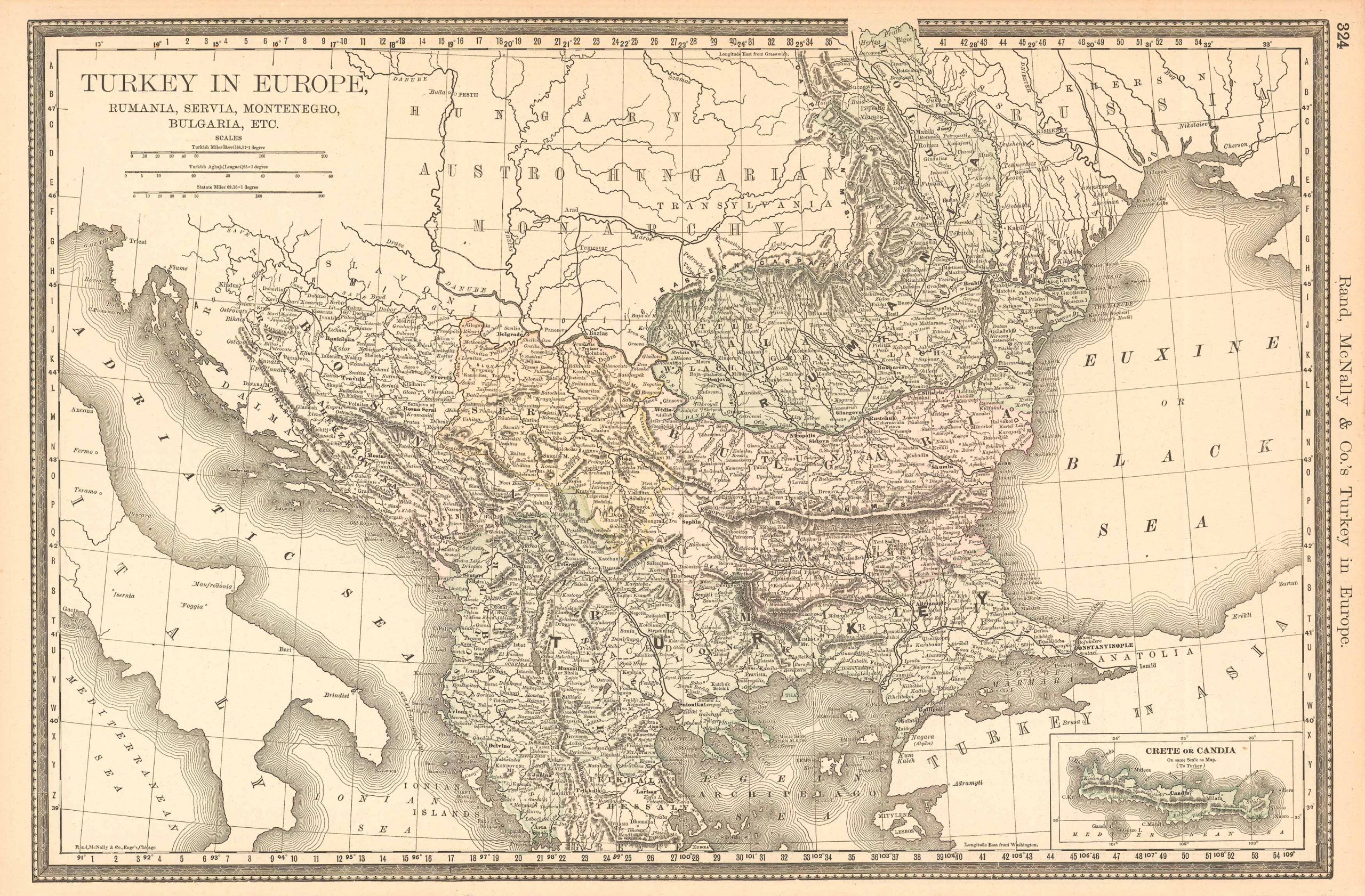
Price: US$50.00 + shipping
Description: We are proud to offer this map of Turkey in Europe, originally produced as part of Rand McNally's Enlarged Business Atlas dated 1891. Although the table of contents shows different editions starting in 1885, we believe this is the first edition of the Enlarged Atlas. Each of these maps accurately locates all cities, towns, post offices, railroad stations, villages, counties, parishes, islands, lakes, rivers, mountains and more. Until McNallyÛªs enlarged Business Atlas, maps had never been produced that provided as much information as these do. Even today, we use these 130 year old maps to locate small towns, villages, and railroad routes that are no more. This map measures 13.25 inches by 19.75 inches.
Seller: Art Source International Inc., Boulder, CO, U.S.A.

Rand, McNally & Company. McNally's 1891 Map of Virginia. , 1891.
Price: US$50.00 + shipping
Description: We are proud to offer this map of Virginia, originally produced as part of Rand McNally's Enlarged Business Atlas dated 1891. Although the table of contents shows different editions starting in 1885, we believe this is the first edition of the Enlarged Atlas. Each of these maps accurately locates all cities, towns, post offices, railroad stations, villages, counties, parishes, islands, lakes, rivers, mountains and more. Until McNallyâs enlarged Business Atlas, maps had never been produced that provided as much information as these do. Even today, we use these 130 year old maps to locate small towns, villages, and railroad routes that are no more. This map measures 19.25 inches by 26 inches.
Seller: Art Source International Inc., Boulder, CO, U.S.A.
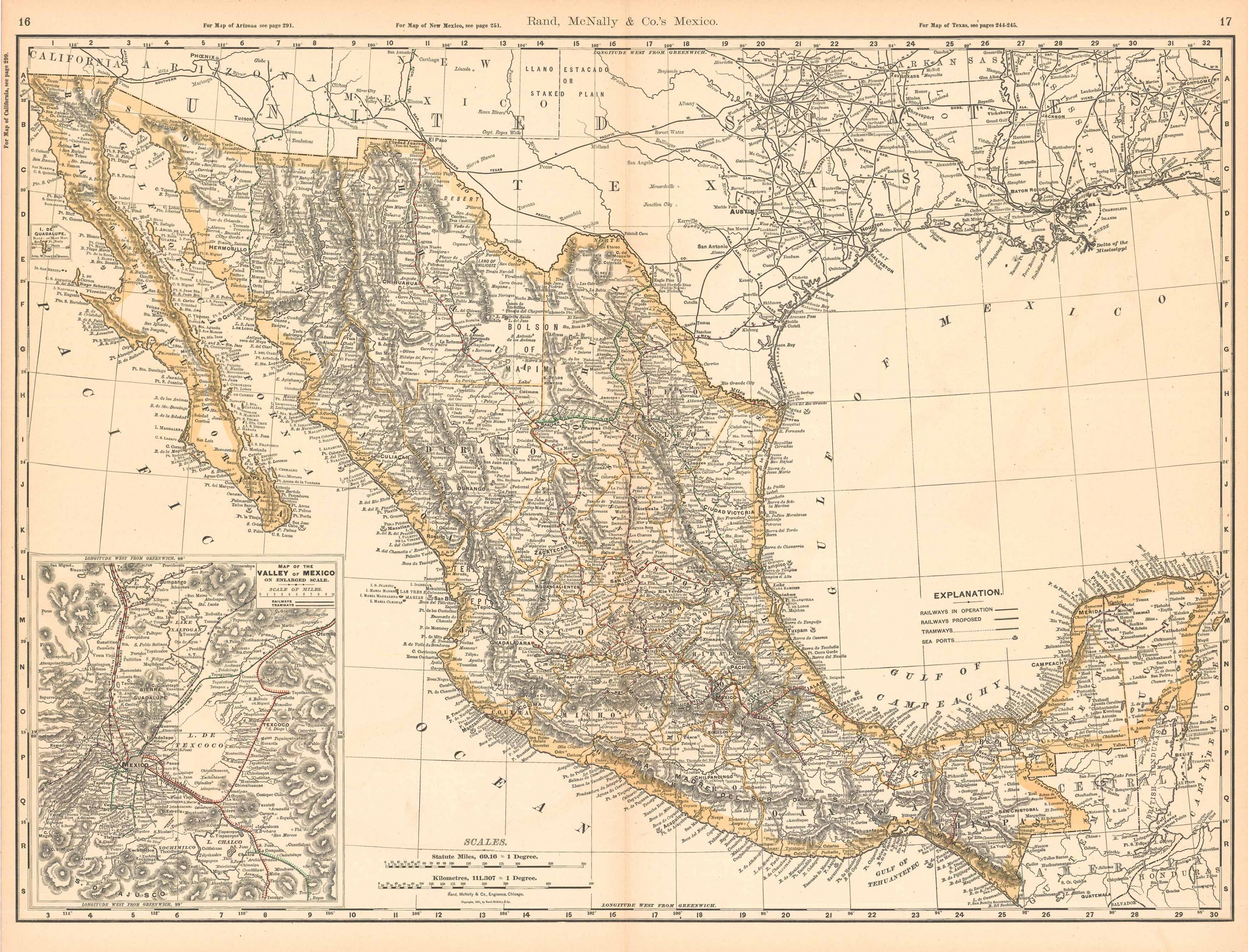
Rand, McNally & Company. McNally's 1891 Map of Mexico. , 1891.
Price: US$50.00 + shipping
Description: We are proud to offer this map of Mexico, originally produced as part of Rand McNally's Enlarged Business Atlas, dated 1891. Although the table of contents shows different editions starting in 1885, we believe this is the first edition of the Enlarged Atlas. Each of these maps accurately locates all cities, towns, post offices, railroad stations, villages, counties, parishes, islands, lakes, rivers, mountains and more. Until McNallyâs enlarged Business Atlas, maps had never been produced that provided as much information as these do. Even today, we use these 130 year old maps to locate small towns, villages, and railroad routes that are no more. This map measures 19 inches by 26 inches.
Seller: Art Source International Inc., Boulder, CO, U.S.A.

Rand, McNally & Company. McNally's 1891 Map of New York. , 1891.
Price: US$50.00 + shipping
Description: We are proud to offer this map of New York, originally produced as part of Rand McNally's Enlarged Business Atlas dated 1891. Although the table of contents shows different editions starting in 1885, we believe this is the first edition of the Enlarged Atlas. Each of these maps accurately locates all cities, towns, post offices, railroad stations, villages, counties, parishes, islands, lakes, rivers, mountains and more. Until McNallyâs enlarged Business Atlas, maps had never been produced that provided as much information as these do. Even today, we use these 130 year old maps to locate small towns, villages, and railroad routes that are no more. This map measures 19 inches by 26 inches.
Seller: Art Source International Inc., Boulder, CO, U.S.A.

Rand, McNally & Company. McNally's 1891 Map of Pennsylvania. , 1891.
Price: US$50.00 + shipping
Description: We are proud to offer this map of Pennsylvania, originally produced as part of Rand McNally's Enlarged Business Atlas dated 1891. Although the table of contents shows different editions starting in 1885, we believe this is the first edition of the Enlarged Atlas. Each of these maps accurately locates all cities, towns, post offices, railroad stations, villages, counties, parishes, islands, lakes, rivers, mountains and more. Until McNallyâs enlarged Business Atlas, maps had never been produced that provided as much information as these do. Even today, we use these 130 year old maps to locate small towns, villages, and railroad routes that are no more. This map measures 19 inches by 26 inches.
Seller: Art Source International Inc., Boulder, CO, U.S.A.

Rand, McNally & Company. McNally's 1891 Map of Russia. , 1891.
Price: US$50.00 + shipping
Description: We are proud to offer this map of Russia, originally produced as part of Rand McNally's Enlarged Business Atlas dated 1891. Although the table of contents shows different editions starting in 1885, we believe this is the first edition of the Enlarged Atlas. Each of these maps accurately locates all cities, towns, post offices, railroad stations, villages, counties, parishes, islands, lakes, rivers, mountains and more. Until McNally??s enlarged Business Atlas, maps had never been produced that provided as much information as these do. Even today, we use these 130 year old maps to locate small towns, villages, and railroad routes that are no more. This map measures 19.75 inches by 13.25.
Seller: Art Source International Inc., Boulder, CO, U.S.A.

Rand McNally & Co. McNally's 1891 Map of South America. , 1891.
Price: US$50.00 + shipping
Description: We are proud to offer this map of South America, originally produced as part of Rand McNally's Enlarged Business Atlas dated 1891. Although the table of contents shows different editions starting in 1885, we believe this is the first edition of the Enlarged Atlas. Each of these maps accurately locates all cities, towns, post offices, railroad stations, villages, counties, parishes, islands, lakes, rivers, mountains and more. Until McNallyÛªs enlarged Business Atlas, maps had never been produced that provided as much information as these do. Even today, we use these 130 year old maps to locate small towns, villages, and railroad routes that are no more. This map measures 13.25 inches by 19.75 inches.
Seller: Art Source International Inc., Boulder, CO, U.S.A.

Rand, McNally & Company. McNally's 1891 Map of Switzerland. , 1891.
Price: US$50.00 + shipping
Description: We are proud to offer this map of Switzerland, originally produced as part of Rand McNally's Enlarged Business Atlas dated 1891. Although the table of contents shows different editions starting in 1885, we believe this is the first edition of the Enlarged Atlas. Each of these maps accurately locates all cities, towns, post offices, railroad stations, villages, counties, parishes, islands, lakes, rivers, mountains and more. Until McNallyâs enlarged Business Atlas, maps had never been produced that provided as much information as these do. Even today, we use these 130 year old maps to locate small towns, villages, and railroad routes that are no more. This map measures 13.25 inches by 19.75 inches.
Seller: Art Source International Inc., Boulder, CO, U.S.A.

Rand McNally & Co.. McNally's 1891 Map of Germany, Southern Part. , 1891.
Price: US$50.00 + shipping
Description: We are proud to offer this map of Germany, Southern Part, originally produced as part of Rand McNally's Enlarged Business Atlas dated 1891. Although the table of contents shows different editions starting in 1885, we believe this is the first edition of the Enlarged Atlas. Each of these maps accurately locates all cities, towns, post offices, railroad stations, villages, counties, parishes, islands, lakes, rivers, mountains and more. Until McNallyÛªs enlarged Business Atlas, maps had never been produced that provided as much information as these do. Even today, we use these 130 year old maps to locate small towns, villages, and railroad routes that are no more. This map measures 13.25 inches by 19.75 inches.
Seller: Art Source International Inc., Boulder, CO, U.S.A.

Rand, McNally & Company. McNally's 1891 Map of Persia. , 1891.
Price: US$50.00 + shipping
Description: We are proud to offer this map of Persia, originally produced as part of Rand McNally's Enlarged Business Atlas dated 1891. Although the table of contents shows different editions starting in 1885, we believe this is the first edition of the Enlarged Atlas. Each of these maps accurately locates all cities, towns, post offices, railroad stations, villages, counties, parishes, islands, lakes, rivers, mountains and more. Until McNallyâs enlarged Business Atlas, maps had never been produced that provided as much information as these do. Even today, we use these 130 year old maps to locate small towns, villages, and railroad routes that are no more. This map measures 13.25 inches by 9.5 inches.
Seller: Art Source International Inc., Boulder, CO, U.S.A.

Rand, McNally & Company. McNally's 1891 Map of the Maritime Provinces. , 1891.
Price: US$50.00 + shipping
Description: We are proud to offer this map of Maritime Provinces, originally produced as part of Rand McNally's Enlarged Business Atlas, dated 1891. Although the table of contents shows different editions starting in 1885, we believe this is the first edition of the Enlarged Atlas. Each of these maps accurately locates all cities, towns, post offices, railroad stations, villages, counties, parishes, islands, lakes, rivers, mountains and more. Until McNallyâs enlarged Business Atlas, maps had never been produced that provided as much information as these do. Even today, we use these 130 year old maps to locate small towns, villages, and railroad routes that are no more. This map measures 13.25 inches by 19.75 inches.
Seller: Art Source International Inc., Boulder, CO, U.S.A.
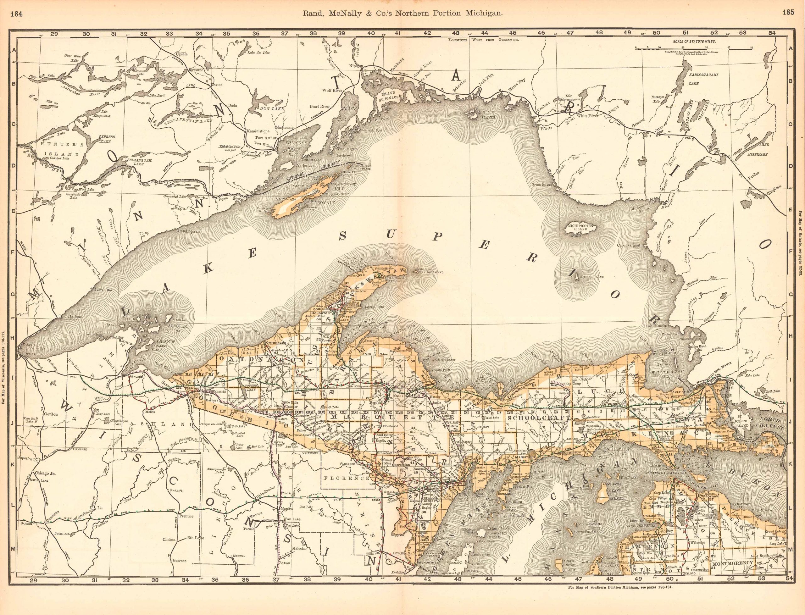
Rand McNally & Co.. McNally's 1891 Map of the Northern Portion of Michigan. , 1891.
Price: US$50.00 + shipping
Description: We are proud to offer this map of the Northern Portion of Michigan, originally produced as part of Rand McNally's Enlarged Business Atlas, dated 1891. Although the table of contents shows different editions starting in 1885, we believe this is the first edition of the Enlarged Atlas. Each of these maps accurately locates all cities, towns, post offices, railroad stations, villages, counties, parishes, islands, lakes, rivers, mountains and more. Until McNallyâs enlarged Business Atlas, maps had never been produced that provided as much information as these do. Even today, we use these 130 year old maps to locate small towns, villages, and railroad routes that are no more.The map measures 26 by 19 inches.
Seller: Art Source International Inc., Boulder, CO, U.S.A.
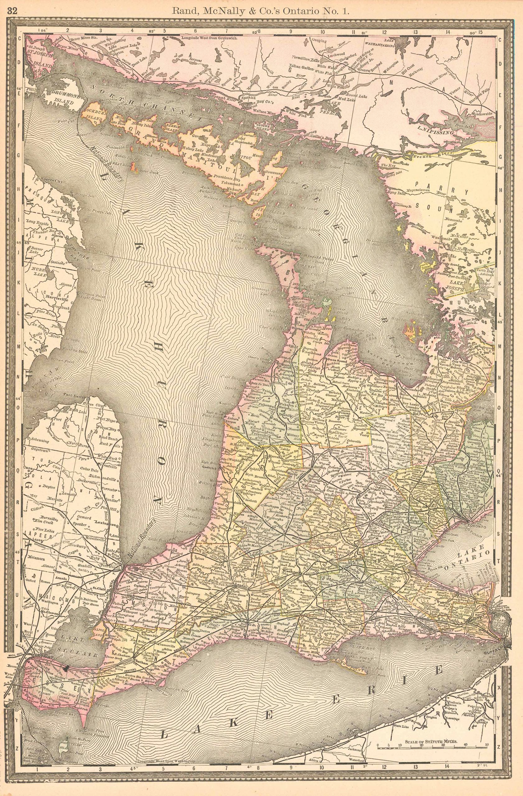
Rand, McNally & Company. McNally's 1891 Map of Ontario. , 1891.
Price: US$50.00 + shipping
Description: We are proud to offer this map of Ontario, originally produced as part of Rand McNally's Enlarged Business Atlas dated 1891. Although the table of contents shows different editions starting in 1885, we believe this is the first edition of the Enlarged Atlas. Each of these maps accurately locates all cities, towns, post offices, railroad stations, villages, counties, parishes, islands, lakes, rivers, mountains and more. Until McNallyâs enlarged Business Atlas, maps had never been produced that provided as much information as these do. Even today, we use these 130 year old maps to locate small towns, villages, and railroad routes that are no more. This map measures 13.25 inches by 19.75 inches.
Seller: Art Source International Inc., Boulder, CO, U.S.A.

Rand, McNally & Company. McNally's 1891 Map of Minnesota. , 1891.
Price: US$50.00 + shipping
Description: We are proud to offer this map of Minnesota, originally produced as part of Rand McNally's Enlarged Business Atlas, dated 1891. Although the table of contents shows different editions starting in 1885, we believe this is the first edition of the Enlarged Atlas. Each of these maps accurately locates all cities, towns, post offices, railroad stations, villages, counties, parishes, islands, lakes, rivers, mountains and more. Until McNallyâs enlarged Business Atlas, maps had never been produced that provided as much information as these do. Even today, we use these 130 year old maps to locate small towns, villages, and railroad routes that are no more. This map measures 26 inches by 19 inches.
Seller: Art Source International Inc., Boulder, CO, U.S.A.
Price: US$51.75 + shipping
Condition: Very Good
Description: Well illus., 6.5 x 4.5", pict wraps, 112pp, spine defective, heavily soiled and worn. Excellent for Victorian door examples. Nice cover illus.
Seller: John K King Used & Rare Books, Detroit, MI, U.S.A.

Price: US$52.75 + shipping
Description: 22 x 15 cm. 514 Seiten. Mit zahlreichen, teils ganzseitigen Illustrationen. Moderner Halblederband mit Rückenschildchen und Titelvergoldung, marmorierte Deckelbezugspapiere. Texanischer Humor im 19. Jahrhundert. - Schönes Exemplar. // On life in Texas after the Civil War. -- Originally published by Rand, McNally a cloth covered hardback, this copy rebound in half leather with marbled boards and gilt lettering to spine. 514 pp., numerous text illustrations. -- Pages tanned, else nice, clean and sound edition in decorative binding. Sprache: Englisch.
Seller: Antiquariat Cassel & Lampe Gbr - Metropolis Books Berlin, Berlin, D, Germany

Duncan, Sara Jeannette. An American Girl in London. Rand, McNally & Company, Chicago, IL, 1891.
Price: US$55.00 + shipping
Condition: Very Good
Description: no date gien (circa 1891); maroon c w/gilt titles, moderte wear at extremities; 290 clean, unmarked pages Size: 12 vo
Seller: Dorley House Books, Inc., Hagerstown, MD, U.S.A.

Rand McNally & Co.. Idaho. , 1891.
Price: US$55.00 + shipping
Description: This very unusual map, from the German edition of Rand McNally and Co.s "New Family Atlas of the World" ("Neuer Familien Atlas der Welt") was produced in 1891. The map has English text, but text and titles in margin are in German. Map has light pastel coloring and identifies counties, roads, railroads, important cities and land-forms.This map measures 12.5 inches by 9.5 inches.
Seller: Art Source International Inc., Boulder, CO, U.S.A.
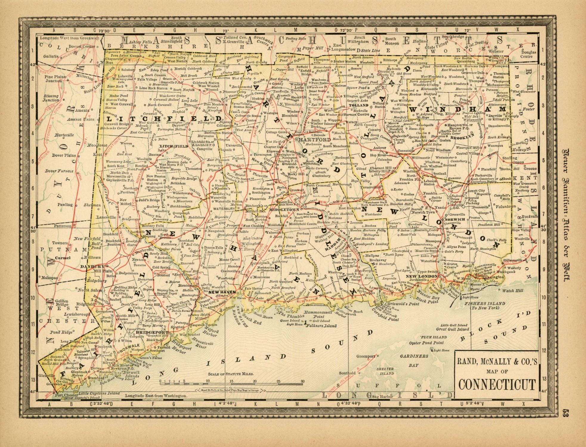
Rand McNally & Co.. Connecticut. , 1891.
Price: US$55.00 + shipping
Description: This very unusual map, from the German edition of Rand McNally and Co.s "New Family Atlas of the World" ("Neuer Familien Atlas der Welt") was produced in 1891. The map has English text, but text and titles in margin are in German. Map has light pastel coloring and identifies counties, roads, railroads, important cities and land-forms.The map measures 12.5 by 9.5 inches.
Seller: Art Source International Inc., Boulder, CO, U.S.A.

Rand McNally & Co.. Central America. , 1891.
Price: US$55.00 + shipping
Description: This very unusual map, from the German edition of Rand McNally and Co.s "New Family Atlas of the World" ("Neuer Familien Atlas der Welt") was produced in 1891. The map has English text, but text and titles in margin are in German. Map has light pastel coloring and identifies counties, roads, railroads, important cities and land-forms. This map measures 9.5 inches by 12.5 inches.
Seller: Art Source International Inc., Boulder, CO, U.S.A.

Rand McNally & Co.. North Dakota. , 1891.
Price: US$55.00 + shipping
Description: This very unusual map, from the German edition of Rand McNally and Co.s "New Family Atlas of the World" ("Neuer Familien Atlas der Welt") was produced in 1891. The map has English text, but text and titles in margin are in German. Map has light pastel coloring and identifies counties, roads, railroads, important cities and land-forms. This map measures 9.5 inches by 12.5 inches.
Seller: Art Source International Inc., Boulder, CO, U.S.A.
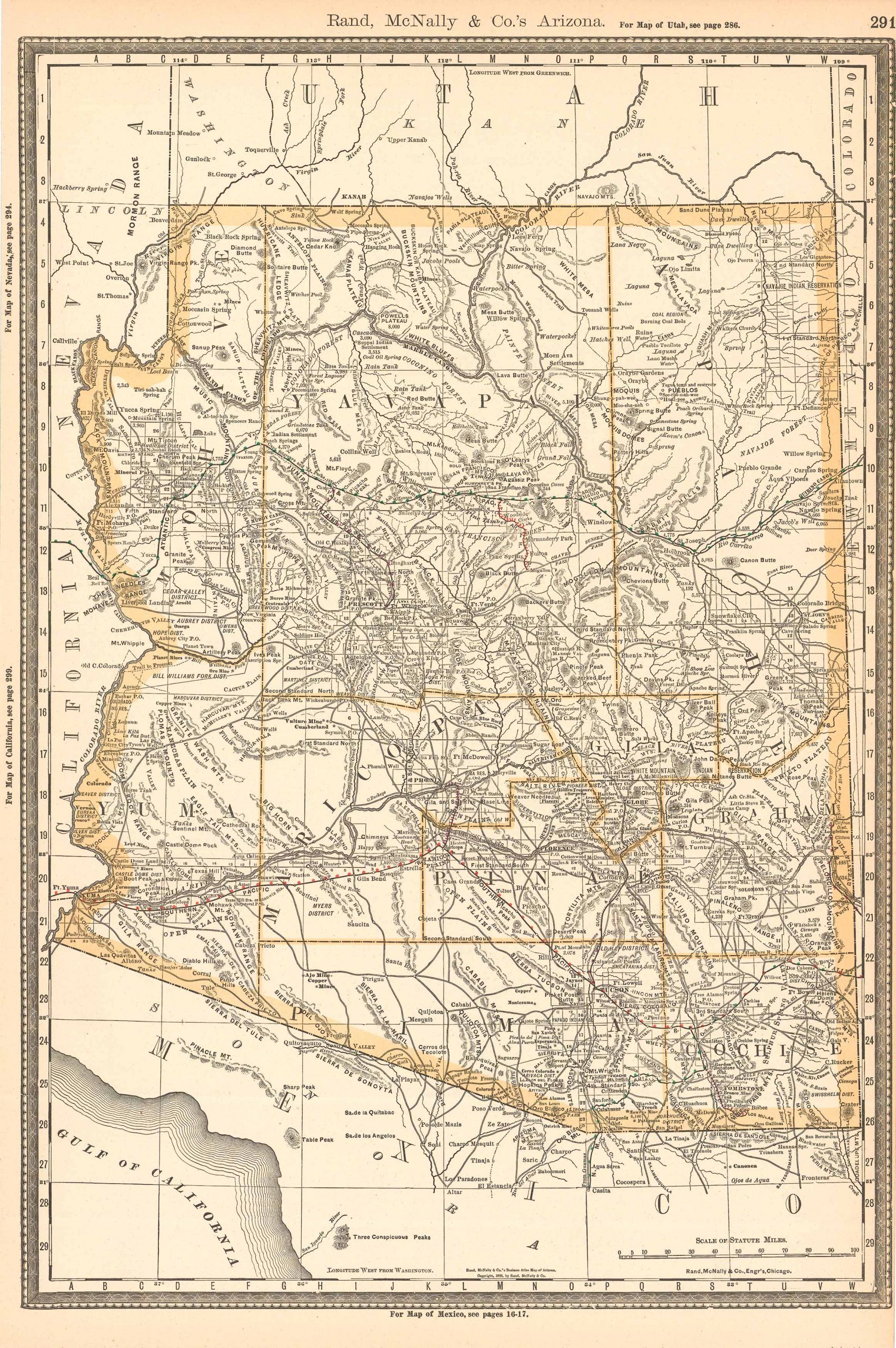
Rand, McNally & Company. McNally's 1891 Map of Arizona. , 1891.
Price: US$55.00 + shipping
Description: We are proud to offer this map of Arizona, originally produced as part of Rand McNally's Enlarged Business Atlas dated 1891. Although the table of contents shows different editions starting in 1885, we believe this is the first edition of the Enlarged Atlas. Each of these maps accurately locates all cities, towns, post offices, railroad stations, villages, counties, parishes, islands, lakes, rivers, mountains and more. Until McNallyâs enlarged Business Atlas, maps had never been produced that provided as much information as these do. Even today, we use these 130 year old maps to locate small towns, villages, and railroad routes that are no more. This map measures 19.75 inches by 13.25 inches.
Seller: Art Source International Inc., Boulder, CO, U.S.A.
Rand, McNally & Company. McNally's 1891 Map of Asia. , 1891.
Price: US$55.00 + shipping
Description: We are proud to offer this map of Asia, originally produced as part of Rand McNally's Enlarged Business Atlas dated 1891. Although the table of contents shows different editions starting in 1885, we believe this is the first edition of the Enlarged Atlas. Each of these maps accurately locates all cities, towns, post offices, railroad stations, villages, counties, parishes, islands, lakes, rivers, mountains and more. Until McNallyâs enlarged Business Atlas, maps had never been produced that provided as much information as these do. Even today, we use these 130 year old maps to locate small towns, villages, and railroad routes that are no more. This map measures 13.25 inches by 19.75 inches.
Seller: Art Source International Inc., Boulder, CO, U.S.A.

Rand, McNally & Company. McNally's 1891 Map of Manitoba. , 1891.
Price: US$55.00 + shipping
Description: We are proud to offer this map of Manitoba, originally produced as part of Rand McNally's Enlarged Business Atlas, dated 1891. Although the table of contents shows different editions starting in 1885, we believe this is the first edition of the Enlarged Atlas. Each of these maps accurately locates all cities, towns, post offices, railroad stations, villages, counties, parishes, islands, lakes, rivers, mountains and more. Until McNallyâs enlarged Business Atlas, maps had never been produced that provided as much information as these do. Even today, we use these 130 year old maps to locate small towns, villages, and railroad routes that are no more. This map measures 13.25 inches by 19.75 inches.
Seller: Art Source International Inc., Boulder, CO, U.S.A.

Rand, McNally & Company. McNally's 1891 Map of China. , 1891.
Price: US$55.00 + shipping
Description: We are proud to offer this map of China, originally produced as part of Rand McNally's Enlarged Business Atlas dated 1891. Although the table of contents shows different editions starting in 1885, we believe this is the first edition of the Enlarged Atlas. Each of these maps accurately locates all cities, towns, post offices, railroad stations, villages, counties, parishes, islands, lakes, rivers, mountains and more. Until McNallyâs enlarged Business Atlas, maps had never been produced that provided as much information as these do. Even today, we use these 130 year old maps to locate small towns, villages, and railroad routes that are no more. This map measures 19.75 inches by 13.25 inches.
Seller: Art Source International Inc., Boulder, CO, U.S.A.

Rand McNally & Co.. McNally's 1891 Map of the Southern Portion of Michigan. , 1891.
Price: US$55.00 + shipping
Description: We are proud to offer this map of the Southern Portion of Michigan, originally produced as part of Rand McNally's Enlarged Business Atlas, dated 1891. Although the table of contents shows different editions starting in 1885, we believe this is the first edition of the Enlarged Atlas. Each of these maps accurately locates all cities, towns, post offices, railroad stations, villages, counties, parishes, islands, lakes, rivers, mountains and more. Until McNallyâs enlarged Business Atlas, maps had never been produced that provided as much information as these do. Even today, we use these 130 year old maps to locate small towns, villages, and railroad routes that are no more.The map measures 19 by 26 inches.
Seller: Art Source International Inc., Boulder, CO, U.S.A.

Rand, McNally & Company. McNally's 1891 Map of the Dominion of Canada. , 1891.
Price: US$55.00 + shipping
Description: We are proud to offer this map of the Dominion of Canada, originally produced as part of Rand McNally's Enlarged Business Atlas, dated 1891. Although the table of contents shows different editions starting in 1885, we believe this is the first edition of the Enlarged Atlas. Each of these maps accurately locates all cities, towns, post offices, railroad stations, villages, counties, parishes, islands, lakes, rivers, mountains and more. Until McNallyâs enlarged Business Atlas, maps had never been produced that provided as much information as these do. Even today, we use these 130 year old maps to locate small towns, villages, and railroad routes that are no more. This map measures 13.25 inches by 19.75 inches.
Seller: Art Source International Inc., Boulder, CO, U.S.A.
Price: US$60.00 + shipping
Condition: Very Good
Description: 8vo. Rebound in modern black cloth. Black leather spine label with gilt lettering. Gilt spine borders. Tight binding and solid boards. Externally like new. Pages moderately chipped. Minor discoloration to pages. Otherwise, clean and unmarked. Ships daily.
Seller: Sequitur Books, Boonsboro, MD, U.S.A.

Rand McNally & Co.. Arizona. , 1891.
Price: US$60.00 + shipping
Description: This very unusual map, from the German edition of Rand McNally and Co.s "New Family Atlas of the World" ("Neuer Familien Atlas der Welt") was produced in 1891. The map has English text, but text and titles in margin are in German. Map has light pastel coloring and identifies counties, roads, railroads, important cities and land-forms. This map measures 12.5 inches by 9.5 inches.
Seller: Art Source International Inc., Boulder, CO, U.S.A.

Rand, McNally & Company. McNally's 1891 Map of Idaho. , 1891.
Price: US$60.00 + shipping
Description: We are proud to offer this map of Idaho, originally produced as part of Rand McNally's Enlarged Business Atlas dated 1891. Although the table of contents shows different editions starting in 1885, we believe this is the first edition of the Enlarged Atlas. Each of these maps accurately locates all cities, towns, post offices, railroad stations, villages, counties, parishes, islands, lakes, rivers, mountains and more. Until McNallyâs enlarged Business Atlas, maps had never been produced that provided as much information as these do. Even today, we use these 130 year old maps to locate small towns, villages, and railroad routes that are no more. This map measures 12.75 inches by 9.75 inches.
Seller: Art Source International Inc., Boulder, CO, U.S.A.

Rand, McNally & Company. McNally's 1891 Map of Louisiana. , 1891.
Price: US$60.00 + shipping
Description: We are proud to offer this map of Louisiana, originally produced as part of Rand McNally's Enlarged Business Atlas dated 1891. Although the table of contents shows different editions starting in 1885, we believe this is the first edition of the Enlarged Atlas. Each of these maps accurately locates all cities, towns, post offices, railroad stations, villages, counties, parishes, islands, lakes, rivers, mountains and more. Until McNallyâs enlarged Business Atlas, maps had never been produced that provided as much information as these do. Even today, we use these 130 year old maps to locate small towns, villages, and railroad routes that are no more. This map measures 13.25 inches by 19.75 inches.
Seller: Art Source International Inc., Boulder, CO, U.S.A.

Rand, McNally & Company. McNally's 1891 Map of Nebraska. , 1891.
Price: US$60.00 + shipping
Description: We are proud to offer this map of Nebraska, originally produced as part of Rand McNally's Enlarged Business Atlas dated 1891. Although the table of contents shows different editions starting in 1885, we believe this is the first edition of the Enlarged Atlas. Each of these maps accurately locates all cities, towns, post offices, railroad stations, villages, counties, parishes, islands, lakes, rivers, mountains and more. Until McNallyâs enlarged Business Atlas, maps had never been produced that provided as much information as these do. Even today, we use these 130 year old maps to locate small towns, villages, and railroad routes that are no more. This map measures 19 inches by 26 inches.
Seller: Art Source International Inc., Boulder, CO, U.S.A.

Rand, McNally & Company. McNally's 1891 Map of Upper Nubia and Habesh or Abyssinia. , 1891.
Price: US$60.00 + shipping
Description: We are proud to offer this map of Upper Nubia and Habesh or Abyssinia originally produced as part of Rand McNally's Enlarged Business Atlas dated 1891. Although the table of contents shows different editions starting in 1885, we believe this is the first edition of the Enlarged Atlas. Each of these maps accurately locates all cities, towns, post offices, railroad stations, villages, counties, parishes, islands, lakes, rivers, mountains and more. Until McNallyâs enlarged Business Atlas, maps had never been produced that provided as much information as these do. Even today, we use these 130 year old maps to locate small towns, villages, and railroad routes that are no more. This map measures 13.25 inches by 19.75 inches.
Seller: Art Source International Inc., Boulder, CO, U.S.A.
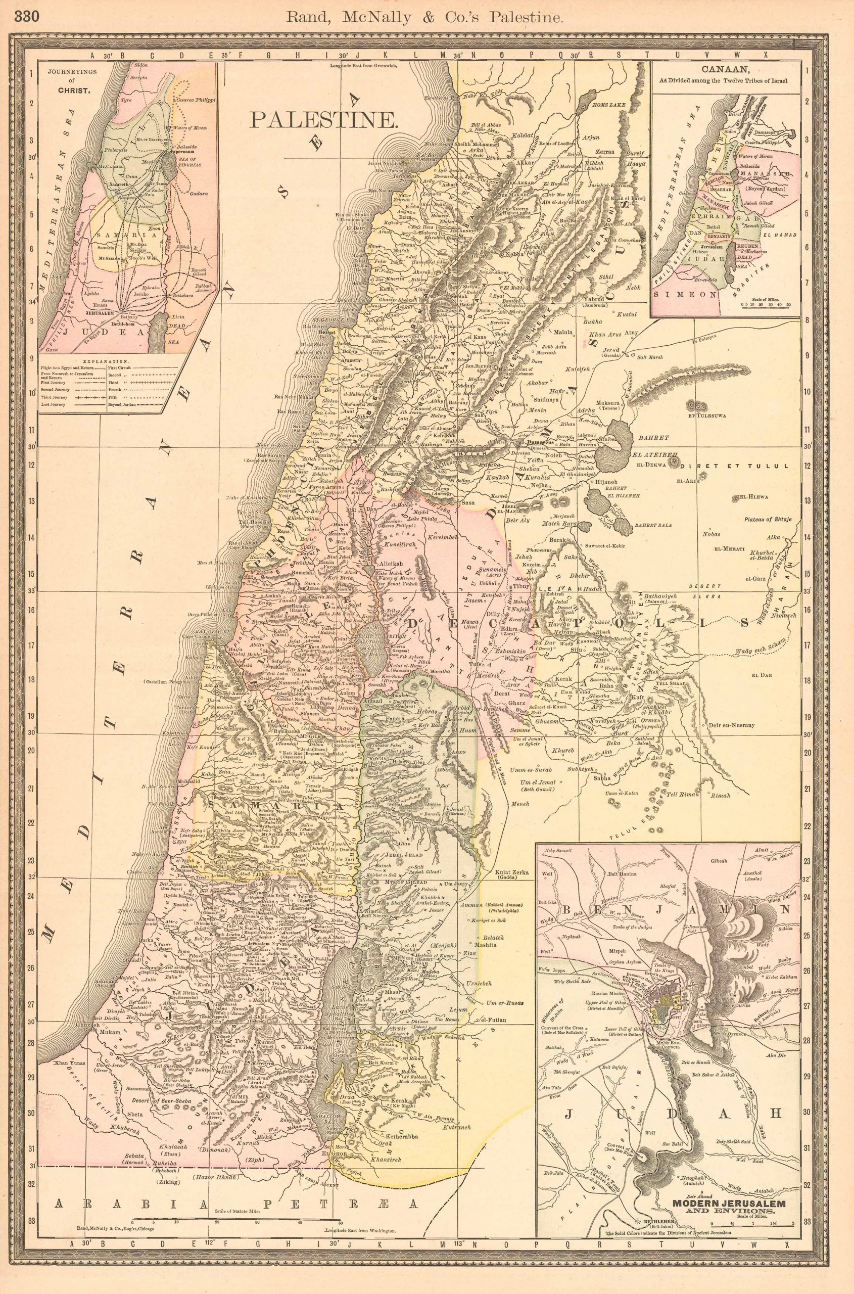
Rand, McNally & Company. McNally's 1891 Map of Palestine. , 1891.
Price: US$60.00 + shipping
Description: We are proud to offer this map of Palestine, originally produced as part of Rand McNally's Enlarged Business Atlas dated 1891. Although the table of contents shows different editions starting in 1885, we believe this is the first edition of the Enlarged Atlas. Each of these maps accurately locates all cities, towns, post offices, railroad stations, villages, counties, parishes, islands, lakes, rivers, mountains and more. Until McNallyâs enlarged Business Atlas, maps had never been produced that provided as much information as these do. Even today, we use these 130 year old maps to locate small towns, villages, and railroad routes that are no more. This map measures 19.75 inches by 13.25 inches.
Seller: Art Source International Inc., Boulder, CO, U.S.A.
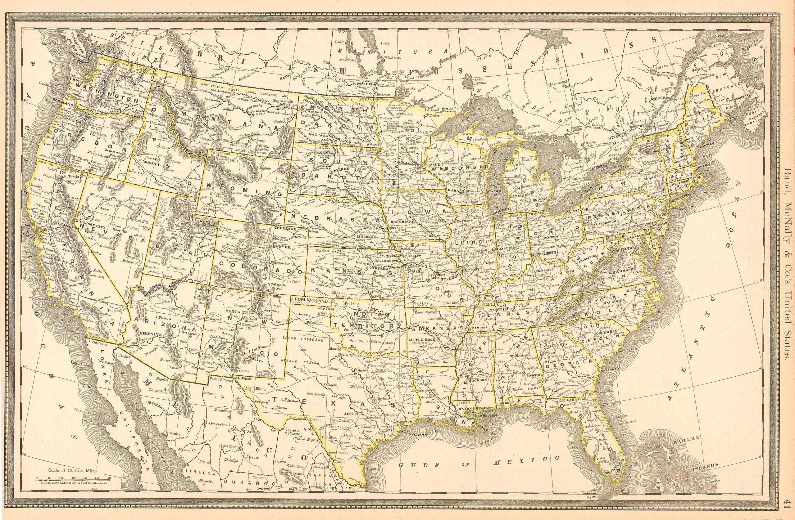
Rand, McNally & Company. McNally's 1891 Map of United States. , 1891.
Price: US$60.00 + shipping
Description: We are proud to offer this map of United States, originally produced as part of Rand McNally's Enlarged Business Atlas dated 1891. Although the table of contents shows different editions starting in 1885, we believe this is the first edition of the Enlarged Atlas. Each of these maps accurately locates all cities, towns, post offices, railroad stations, villages, counties, parishes, islands, lakes, rivers, mountains and more. Until McNallyâs enlarged Business Atlas, maps had never been produced that provided as much information as these do. Even today, we use these 130 year old maps to locate small towns, villages, and railroad routes that are no more. This map measures 13.75 inches by 19.75 inches.
Seller: Art Source International Inc., Boulder, CO, U.S.A.

Rand, McNally & Company. McNally's 1891 Map of Central America. , 1891.
Price: US$60.00 + shipping
Description: We are proud to offer this map of Central America, originally produced as part of Rand McNally's Enlarged Business Atlas, dated 1891. Although the table of contents shows different editions starting in 1885, we believe this is the first edition of the Enlarged Atlas. Each of these maps accurately locates all cities, towns, post offices, railroad stations, villages, counties, parishes, islands, lakes, rivers, mountains and more. Until McNallyâs enlarged Business Atlas, maps had never been produced that provided as much information as these do. Even today, we use these 130 year old maps to locate small towns, villages, and railroad routes that are no more. This map measures 13.25 inches by 19.75 inches.
Seller: Art Source International Inc., Boulder, CO, U.S.A.
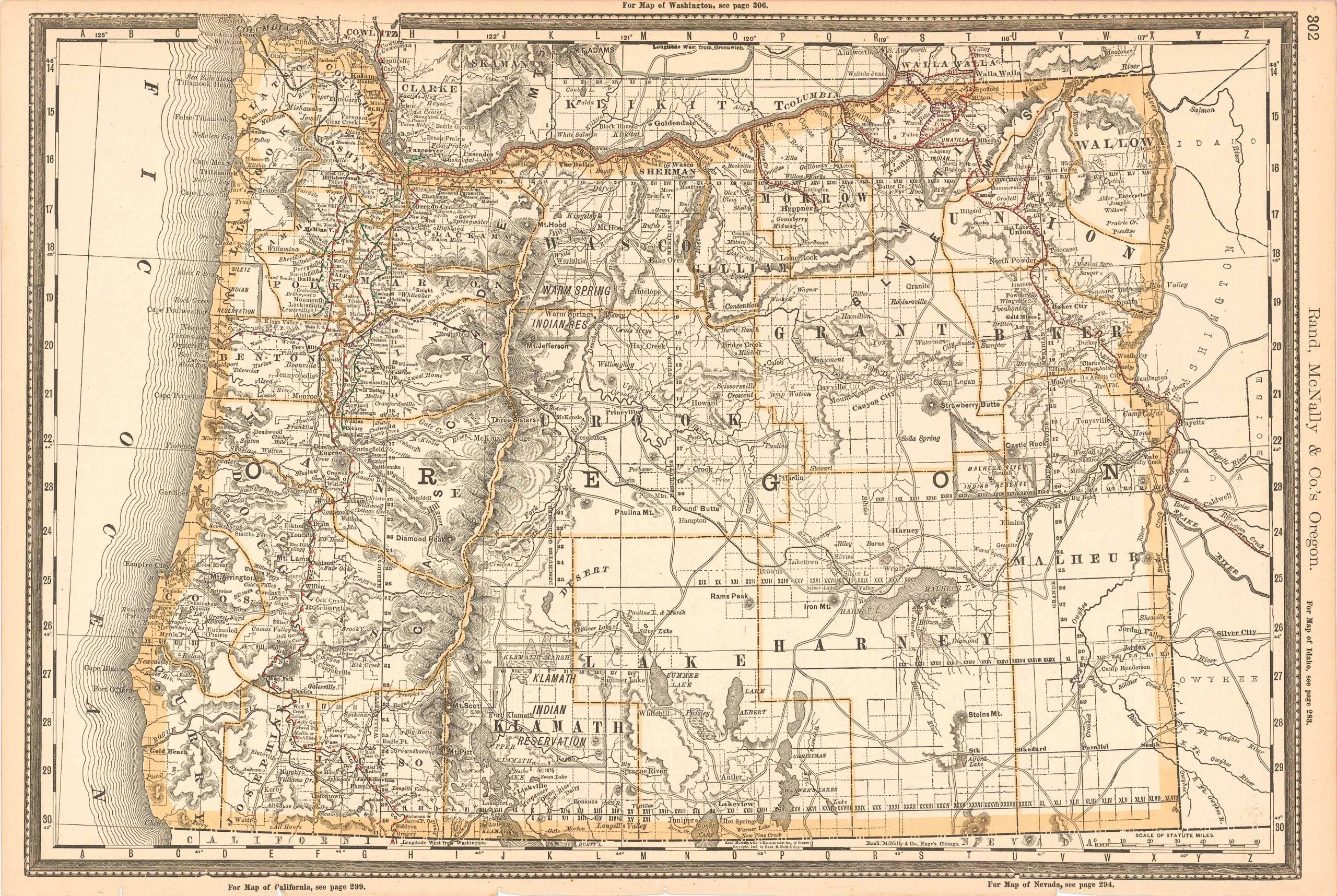
Rand McNally. McNally's 1891 Map of Oregon. , 1891.
Price: US$60.00 + shipping
Description: We are proud to offer this map of Oregon, originally produced as part of Rand McNally's Enlarged Business Atlas dated 1891. Although the table of contents shows different editions starting in 1885, we believe this is the first edition of the Enlarged Atlas. Each of these maps accurately locates all cities, towns, post offices, railroad stations, villages, counties, parishes, islands, lakes, rivers, mountains and more. Until McNally??s enlarged Business Atlas, maps had never been produced that provided as much information as these do. Even today, we use these 130 year old maps to locate small towns, villages, and railroad routes that are no more.The size of the map is 19.75 x 13.25
Seller: Art Source International Inc., Boulder, CO, U.S.A.
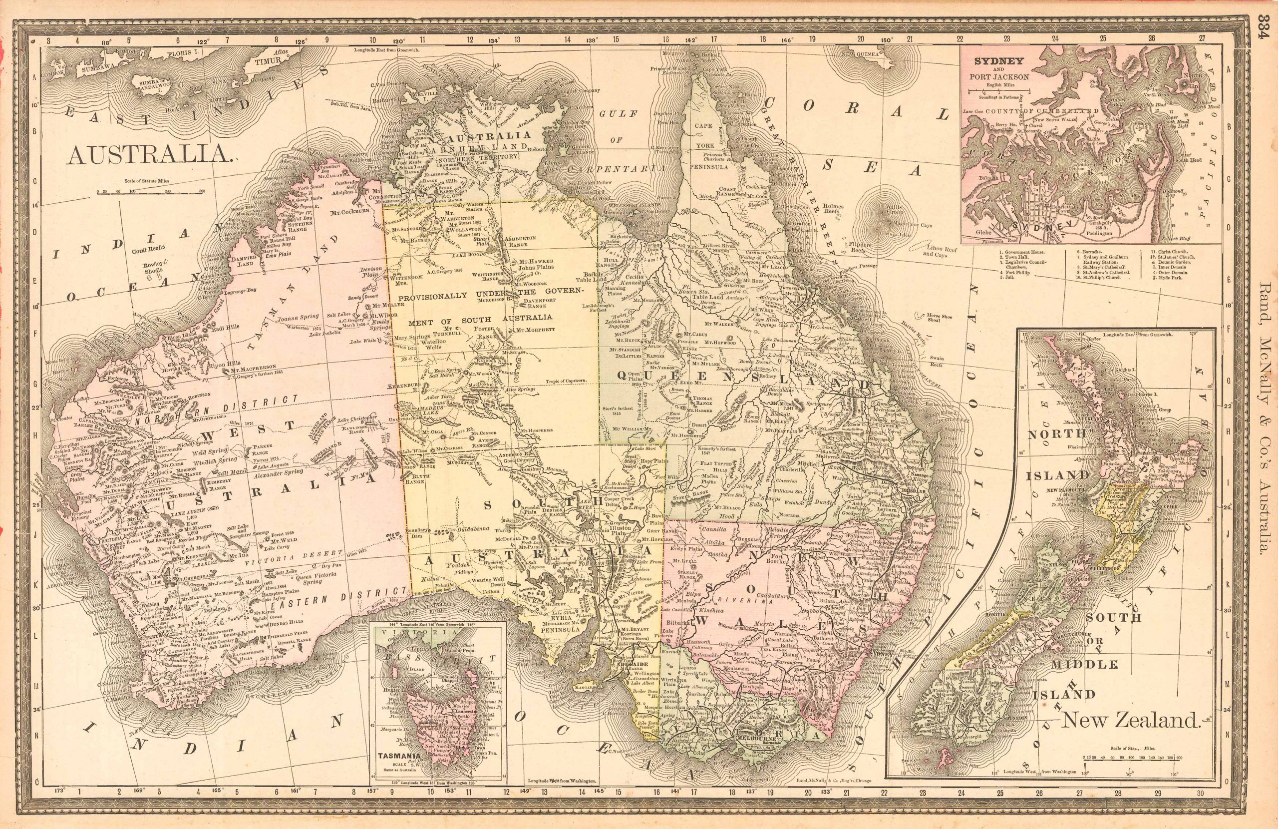
Rand, McNally & Company. McNally's 1891 Map of Australia. , 1891.
Price: US$60.00 + shipping
Description: We are proud to offer this map of Australia, originally produced as part of Rand McNally's Enlarged Business Atlas dated 1891. Although the table of contents shows different editions starting in 1885, we believe this is the first edition of the Enlarged Atlas. Each of these maps accurately locates all cities, towns, post offices, railroad stations, villages, counties, parishes, islands, lakes, rivers, mountains and more. Until McNallyâs enlarged Business Atlas, maps had never been produced that provided as much information as these do. Even today, we use these 130 year old maps to locate small towns, villages, and railroad routes that are no more. This map measures 13.25 inches by 19.75 inches.
Seller: Art Source International Inc., Boulder, CO, U.S.A.

Rand, McNally & Company. McNally's 1891 Map of Missouri. , 1891.
Price: US$60.00 + shipping
Description: We are proud to offer this map of Missouri, originally produced as part of Rand McNally's Enlarged Business Atlas dated 1891. Although the table of contents shows different editions starting in 1885, we believe this is the first edition of the Enlarged Atlas. Each of these maps accurately locates all cities, towns, post offices, railroad stations, villages, counties, parishes, islands, lakes, rivers, mountains and more. Until McNallyâs enlarged Business Atlas, maps had never been produced that provided as much information as these do. Even today, we use these 130 year old maps to locate small towns, villages, and railroad routes that are no more. This map measures 19 inches by 26 inches.
Seller: Art Source International Inc., Boulder, CO, U.S.A.
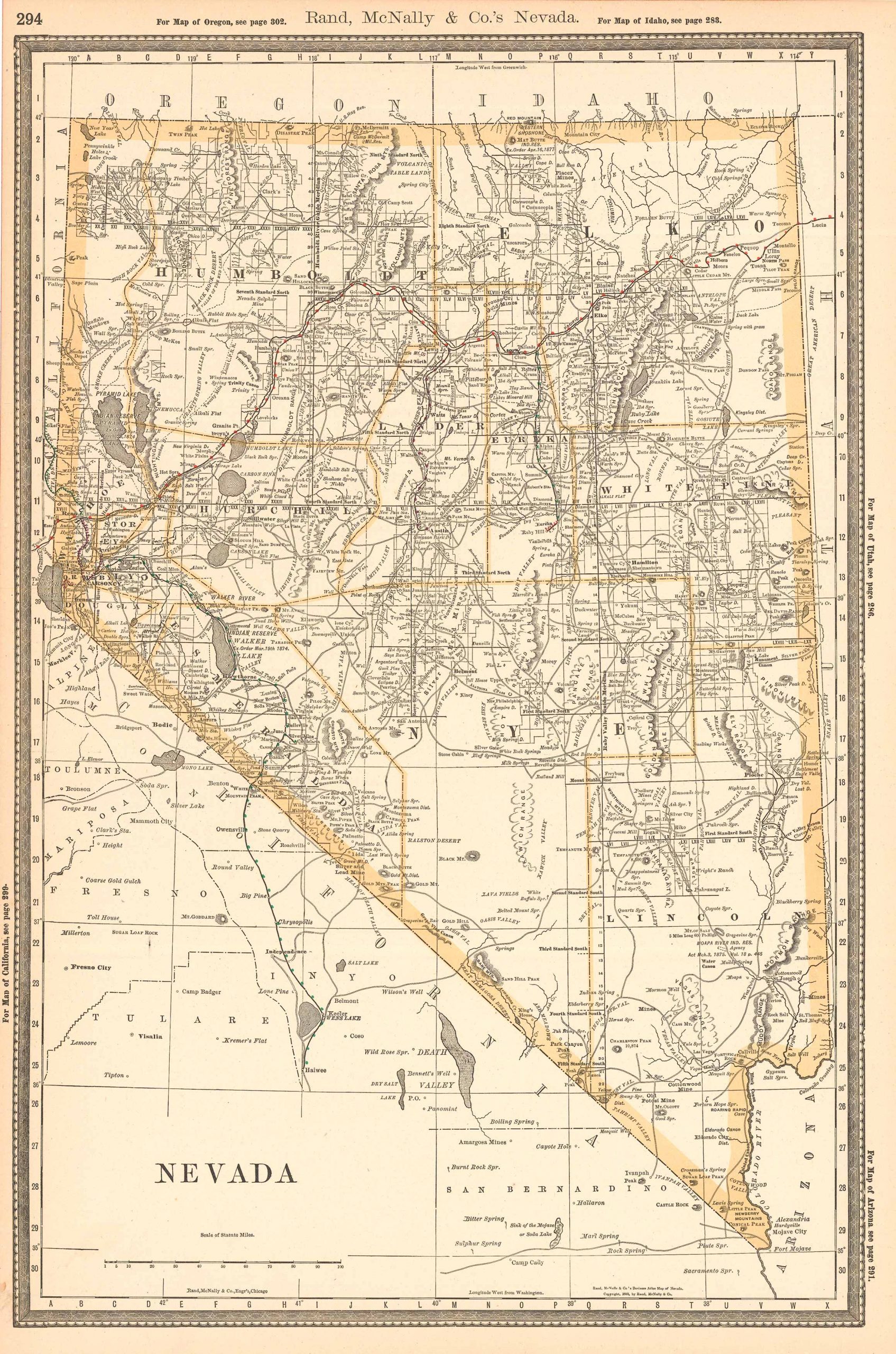
Rand, McNally & Company. McNally's 1891 Map of Nevada. , 1891.
Price: US$60.00 + shipping
Description: We are proud to offer this map of Nevada, originally produced as part of Rand McNally's Enlarged Business Atlas dated 1891. Although the table of contents shows different editions starting in 1885, we believe this is the first edition of the Enlarged Atlas. Each of these maps accurately locates all cities, towns, post offices, railroad stations, villages, counties, parishes, islands, lakes, rivers, mountains and more. Until McNallyâs enlarged Business Atlas, maps had never been produced that provided as much information as these do. Even today, we use these 130 year old maps to locate small towns, villages, and railroad routes that are no more. This map measures 19.75 inches by 13.25 inches.
Seller: Art Source International Inc., Boulder, CO, U.S.A.
Price: US$65.00 + shipping
Condition: Very Good
Description: Bound in full grain leather with gold graphic decor . Five ribs on spine . Marble paper pastedowns and endpapers . The book is clean , no marks of any kind . The back hinge is beginning to loosen .
Seller: The History Place, Palestine, TX, U.S.A.

Rand McNally & Co.. Wyoming. , 1891.
Price: US$65.00 + shipping
Description: This very unusual map, from the German edition of Rand McNally and Co.s "New Family Atlas of the World" ("Neuer Familien Atlas der Welt") was produced in 1891. The map has English text, but text and titles in margin are in German. Map has light pastel coloring and identifies counties, roads, railroads, important cities and land-forms. This map measures 9.5 inches by 12.5 inches.
Seller: Art Source International Inc., Boulder, CO, U.S.A.

Rand, McNally & Company. McNally's 1891 Map of the West Indies. , 1891.
Price: US$65.00 + shipping
Description: We are proud to offer this map of the West Indies, originally produced as part of Rand McNally's Enlarged Business Atlas dated 1891. Although the table of contents shows different editions starting in 1885, we believe this is the first edition of the Enlarged Atlas. Each of these maps accurately locates all cities, towns, post offices, railroad stations, villages, counties, parishes, islands, lakes, rivers, mountains and more. Until McNallyâs enlarged Business Atlas, maps had never been produced that provided as much information as these do. Even today, we use these 130 year old maps to locate small towns, villages, and railroad routes that are no more. This map measures inches by inches.
Seller: Art Source International Inc., Boulder, CO, U.S.A.
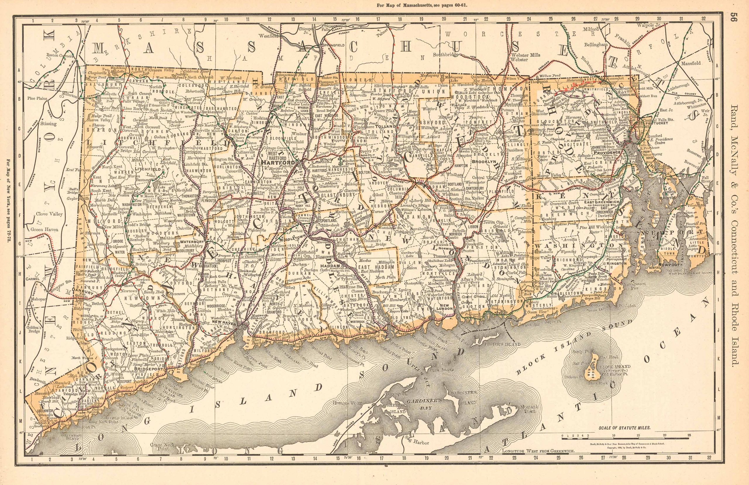
Rand, McNally & Company. McNally's 1891 Map of Connecticut and Rhode Island. , 1891.
Price: US$65.00 + shipping
Description: We are proud to offer this map of Connecticut and Rhode Island, originally produced as part of Rand McNally's Enlarged Business Atlas, dated 1891. Although the table of contents shows different editions starting in 1885, we believe this is the first edition of the Enlarged Atlas. Each of these maps accurately locates all cities, towns, post offices, railroad stations, villages, counties, parishes, islands, lakes, rivers, mountains and more. Until McNally??s enlarged Business Atlas, maps had never been produced that provided as much information as these do. Even today, we use these 130 year old maps to locate small towns, villages, and railroad routes that are no more. This map measures 13.25 inches by 19.75.
Seller: Art Source International Inc., Boulder, CO, U.S.A.
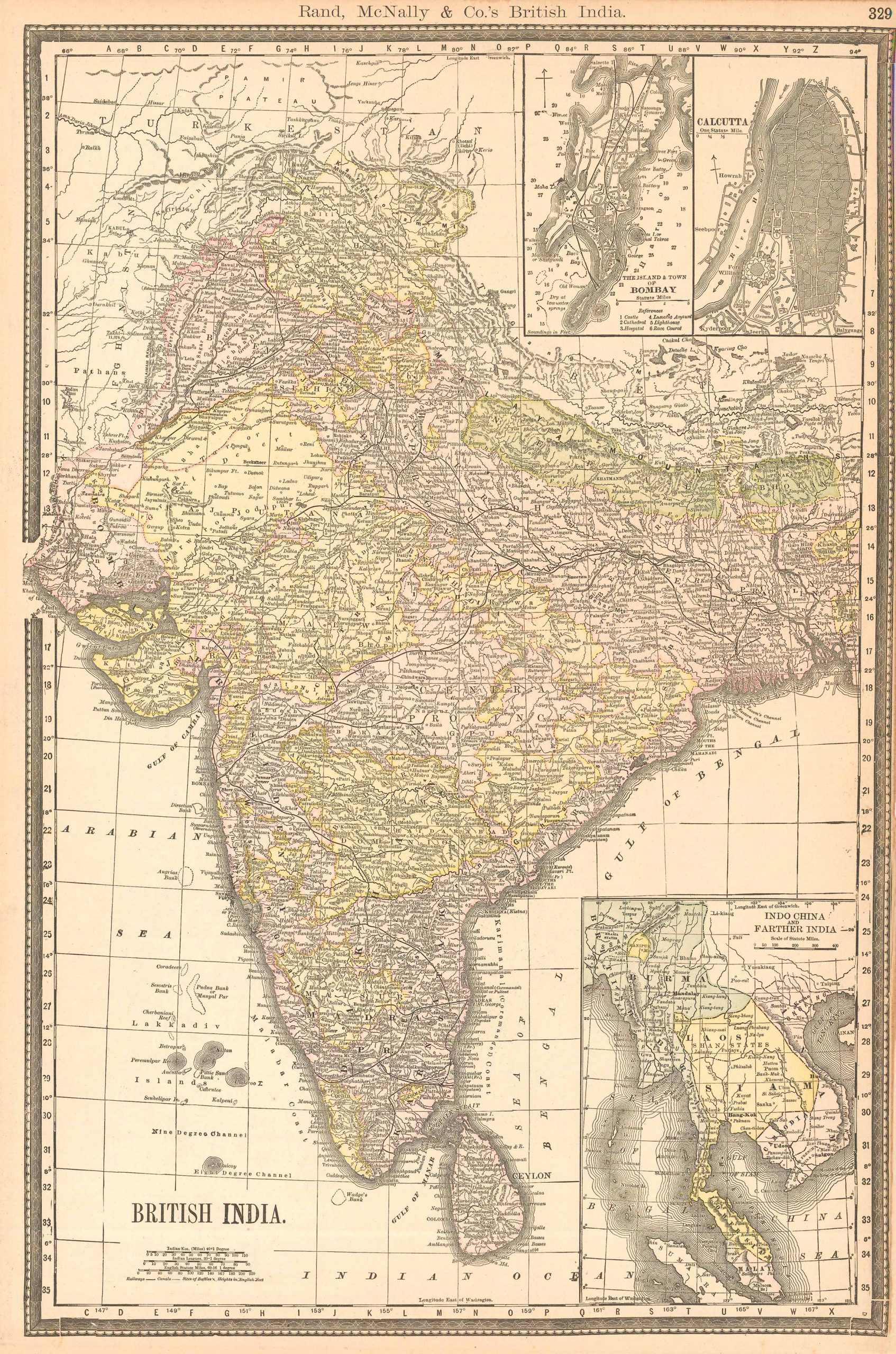
Rand, McNally & Company. McNally's 1891 Map of British India. , 1891.
Price: US$65.00 + shipping
Description: We are proud to offer this map of British India, originally produced as part of Rand McNally's Enlarged Business Atlas, dated 1891. Although the table of contents shows different editions starting in 1885, we believe this is the first edition of the Enlarged Atlas. Each of these maps accurately locates all cities, towns, post offices, railroad stations, villages, counties, parishes, islands, lakes, rivers, mountains and more. Until McNallyâs enlarged Business Atlas, maps had never been produced that provided as much information as these do. Even today, we use these 130 year old maps to locate small towns, villages, and railroad routes that are no more. This map measures 19.75 inches by 13.25 inches.
Seller: Art Source International Inc., Boulder, CO, U.S.A.
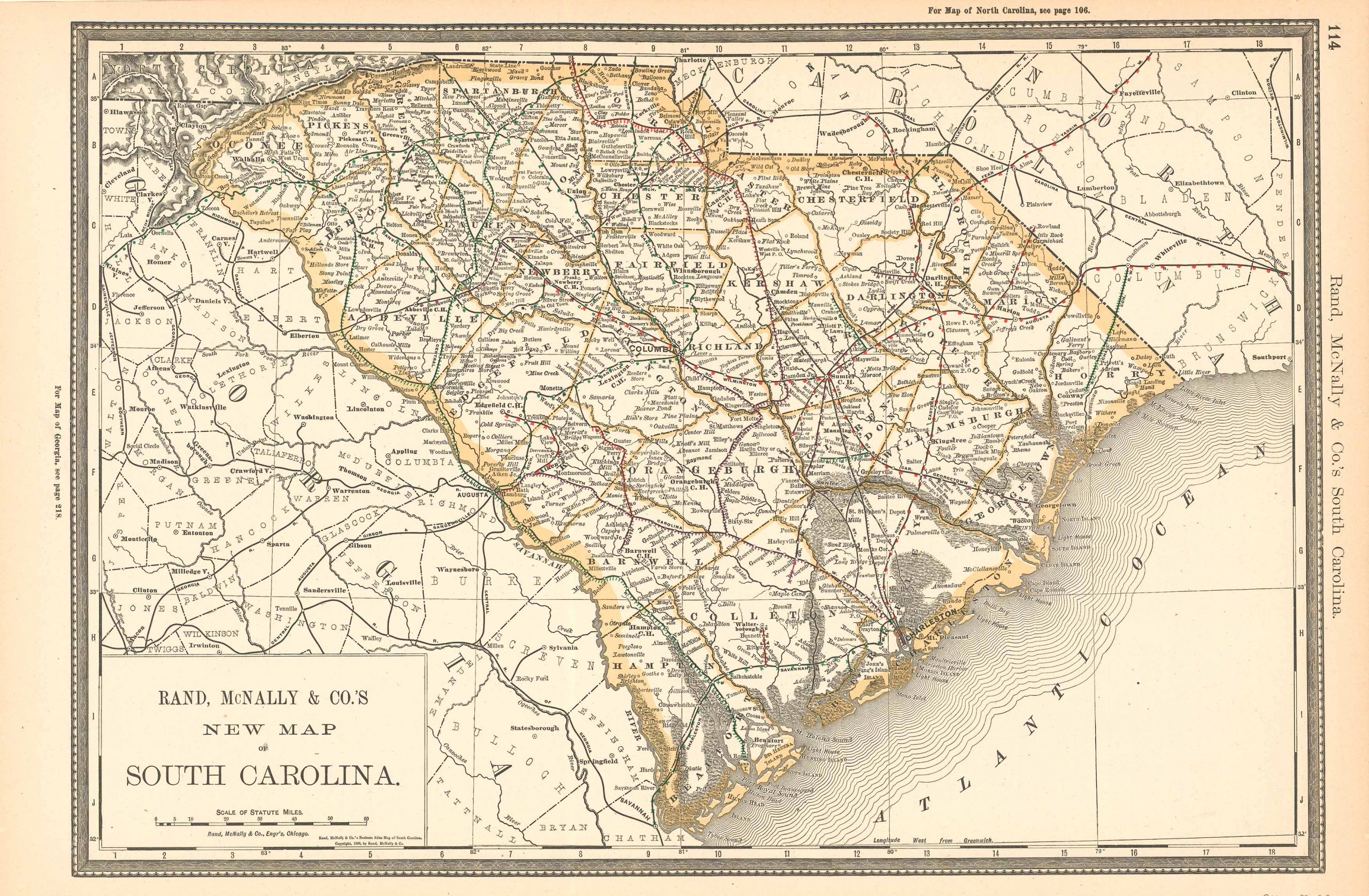
Rand, McNally & Company. McNally's 1891 Map of South Carolina. , 1891.
Price: US$65.00 + shipping
Description: We are proud to offer this map of South Carolina, originally produced as part of Rand McNally's Enlarged Business Atlas dated 1891. Although the table of contents shows different editions starting in 1885, we believe this is the first edition of the Enlarged Atlas. Each of these maps accurately locates all cities, towns, post offices, railroad stations, villages, counties, parishes, islands, lakes, rivers, mountains and more. Until McNally??s enlarged Business Atlas, maps had never been produced that provided as much information as these do. Even today, we use these 130 year old maps to locate small towns, villages, and railroad routes that are no more. This map measures 13.75 inches by 19.75.
Seller: Art Source International Inc., Boulder, CO, U.S.A.

Rand, McNally & Company. McNally's 1891 Map of Illinois. , 1891.
Price: US$65.00 + shipping
Description: We are proud to offer this map of Illinois, originally produced as part of Rand McNally's Enlarged Business Atlas, dated 1891. Although the table of contents shows different editions starting in 1885, we believe this is the first edition of the Enlarged Atlas. Each of these maps accurately locates all cities, towns, post offices, railroad stations, villages, counties, parishes, islands, lakes, rivers, mountains and more. Until McNallyâs enlarged Business Atlas, maps had never been produced that provided as much information as these do. Even today, we use these 130 year old maps to locate small towns, villages, and railroad routes that are no more. This map measures 26 inches by 19 inches.
Seller: Art Source International Inc., Boulder, CO, U.S.A.

Rand, McNally & Company. McNally's 1891 Map of British Columbia. , 1891.
Price: US$65.00 + shipping
Description: We are proud to offer this map of British Columbia, originally produced as part of Rand McNally's Enlarged Business Atlas, dated 1891. Although the table of contents shows different editions starting in 1885, we believe this is the first edition of the Enlarged Atlas. Each of these maps accurately locates all cities, towns, post offices, railroad stations, villages, counties, parishes, islands, lakes, rivers, mountains and more. Until McNallyâs enlarged Business Atlas, maps had never been produced that provided as much information as these do. Even today, we use these 130 year old maps to locate small towns, villages, and railroad routes that are no more. This map measures 13.25 inches by 19.75 inches.
Seller: Art Source International Inc., Boulder, CO, U.S.A.
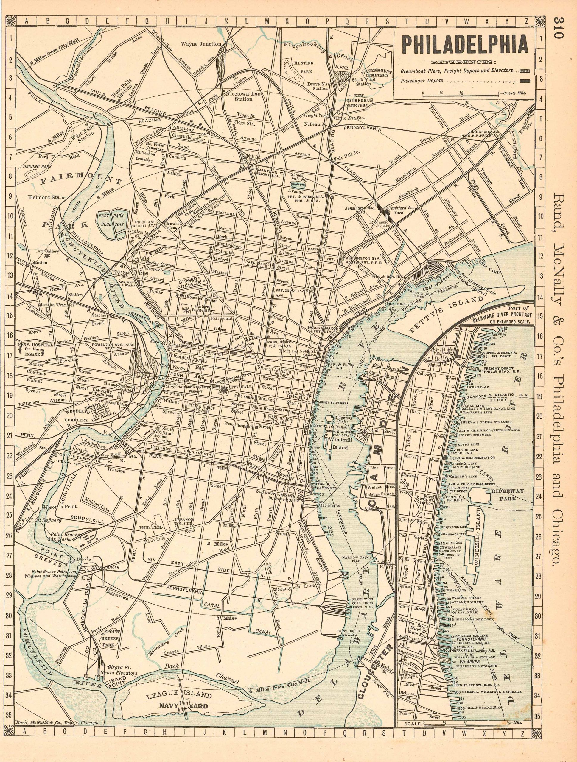
Rand, McNally & Company. McNally's 1891 Map of Philadelphia. , 1891.
Price: US$70.00 + shipping
Description: We are proud to offer this map of Philadelphia, originally produced as part of Rand McNally's Enlarged Business Atlas dated 1891. Although the table of contents shows different editions starting in 1885, we believe this is the first edition of the Enlarged Atlas. Each of these maps accurately locates all cities, towns, post offices, railroad stations, villages, counties, parishes, islands, lakes, rivers, mountains and more. Until McNallyâs enlarged Business Atlas, maps had never been produced that provided as much information as these do. Even today, we use these 130 year old maps to locate small towns, villages, and railroad routes that are no more. This map measures 12.75 inches by 9.75 inches.
Seller: Art Source International Inc., Boulder, CO, U.S.A.

Rand McNally. McNally's 1891 Map of Spain and Portugal. , 1891.
Price: US$70.00 + shipping
Description: We are proud to offer this map of Spain and Portugal, originally produced as part of Rand McNally's Enlarged Business Atlas dated 1891. Although the table of contents shows different editions starting in 1885, we believe this is the first edition of the Enlarged Atlas. Each of these maps accurately locates all cities, towns, post offices, railroad stations, villages, counties, parishes, islands, lakes, rivers, mountains and more. Until McNally??s enlarged Business Atlas, maps had never been produced that provided as much information as these do. Even today, we use these 130 year old maps to locate small towns, villages, and railroad routes that are no more.The size of the map is 19.75 x 13.25
Seller: Art Source International Inc., Boulder, CO, U.S.A.

Rand McNally. McNally's 1891 Map of Scotland. , 1891.
Price: US$75.00 + shipping
Description: We are proud to offer this map of Scotland, originally produced as part of Rand McNally's Enlarged Business Atlas dated 1891. Although the table of contents shows different editions starting in 1885, we believe this is the first edition of the Enlarged Atlas. Each of these maps accurately locates all cities, towns, post offices, railroad stations, villages, counties, parishes, islands, lakes, rivers, mountains and more. Until McNally??s enlarged Business Atlas, maps had never been produced that provided as much information as these do. Even today, we use these 130 year old maps to locate small towns, villages, and railroad routes that are no more.The size of the map is 13.25 x 19.75
Seller: Art Source International Inc., Boulder, CO, U.S.A.
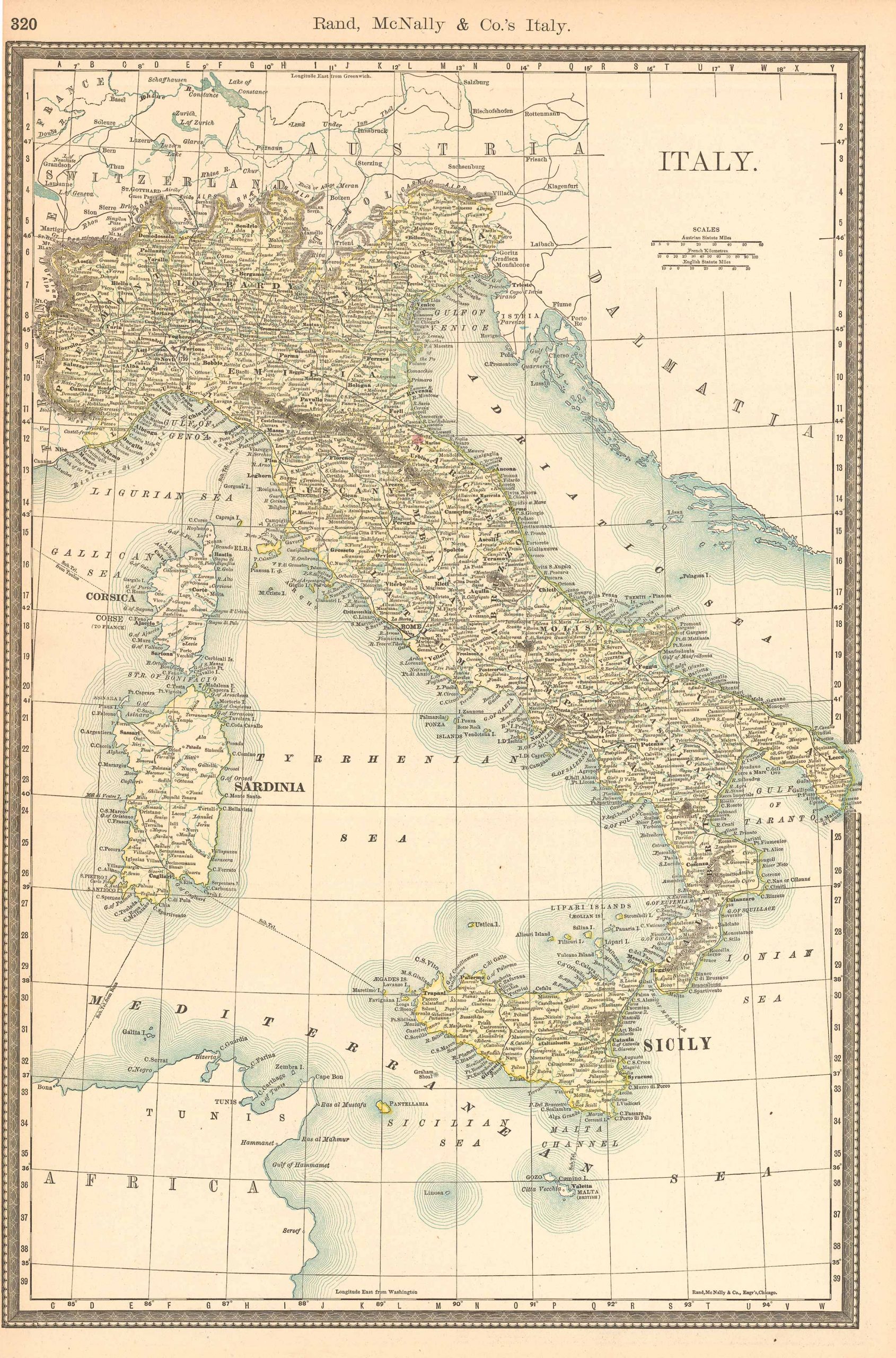
Rand McNally. McNally's 1891 Map of Italy. , 1891.
Price: US$75.00 + shipping
Description: We are proud to offer this map of Italy, originally produced as part of Rand McNally's Enlarged Business Atlas dated 1891. Although the table of contents shows different editions starting in 1885, we believe this is the first edition of the Enlarged Atlas. Each of these maps accurately locates all cities, towns, post offices, railroad stations, villages, counties, parishes, islands, lakes, rivers, mountains and more. Until McNally??s enlarged Business Atlas, maps had never been produced that provided as much information as these do. Even today, we use these 130 year old maps to locate small towns, villages, and railroad routes that are no more.The size of the map is 13.25 x 19.75
Seller: Art Source International Inc., Boulder, CO, U.S.A.
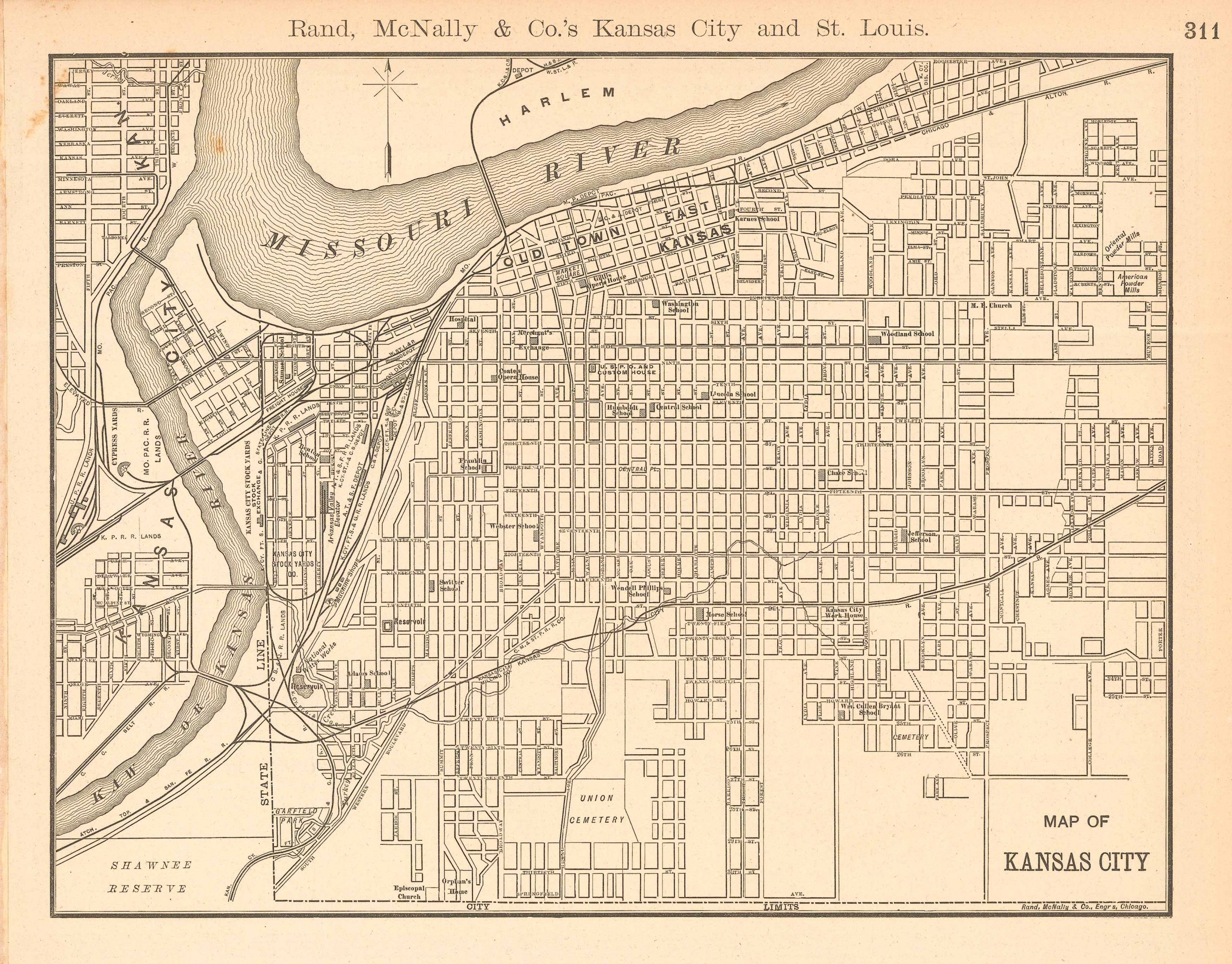
Rand, McNally & Company. McNally's 1891 Map of Kansas City. , 1891.
Price: US$75.00 + shipping
Description: We are proud to offer this map of Kansas City, originally produced as part of Rand McNally's Enlarged Business Atlas dated 1891. Although the table of contents shows different editions starting in 1885, we believe this is the first edition of the Enlarged Atlas. Each of these maps accurately locates all cities, towns, post offices, railroad stations, villages, counties, parishes, islands, lakes, rivers, mountains and more. Until McNallyâs enlarged Business Atlas, maps had never been produced that provided as much information as these do. Even today, we use these 130 year old maps to locate small towns, villages, and railroad routes that are no more. This map measures 13.25 inches by 10.5 inches.
Seller: Art Source International Inc., Boulder, CO, U.S.A.
Price: US$76.92 + shipping
Description: 47 S., 2 Bl. Mit 1 mehrfach gefalteten farbigen Karte (52 x 70 cm). Text in englischer Sprache. - Vorderdeckel etwas berieben, Seiten leicht gebräunt, Karte in sehr gutem Zustand. Privatstempel auf Innendeckel. Sprache: Englisch Gewicht in Gramm: 0
Seller: Antiquariat Joachim Lührs, Hamburg, Germany
Rand, McNally & Company. McNally's 1891 Map of Wyoming. , 1891.
Price: US$80.00 + shipping
Description: We are proud to offer this map of Wyoming, originally produced as part of Rand McNally's Enlarged Business Atlas dated 1891. Although the table of contents shows different editions starting in 1885, we believe this is the first edition of the Enlarged Atlas. Each of these maps accurately locates all cities, towns, post offices, railroad stations, villages, counties, parishes, islands, lakes, rivers, mountains and more. Until McNally??s enlarged Business Atlas, maps had never been produced that provided as much information as these do. Even today, we use these 130 year old maps to locate small towns, villages, and railroad routes that are no more. This map measures 13.25 inches by 19.75.
Seller: Art Source International Inc., Boulder, CO, U.S.A.
Ingersoll, Ernest. A WEEK IN NEW YORK. Rand McNally & Company, New York, 1891.
Price: US$85.00 + shipping
Condition: Good
Description: Pliable red cloth binding, marbled edges. 328+(9) pages. Illustrated (including "Base Ball Ground 155th Str. & 8th Ave.", "The Madison Square Garden," "The Brooklyn Bridge", etc). Includes a large foldout map, in color, inside a pocket in the rear board. An especially interesting chapter entitled "A Ramble at Night" is devoted to "slumming," with advice to do so only in a sober state, to visit Five Point, Mulberry Street, Chinatown with its opium smoking rooms, The Bowery, The Russian Quarter, the brick tenements of German Jews or Bohemians, and finally the Fourth Ward, a gathering of Socialists and Anarchists. Good plus condition with one very small knick in right edge of front board.
Seller: Jim Hodgson Books, Churchton, MD, U.S.A.
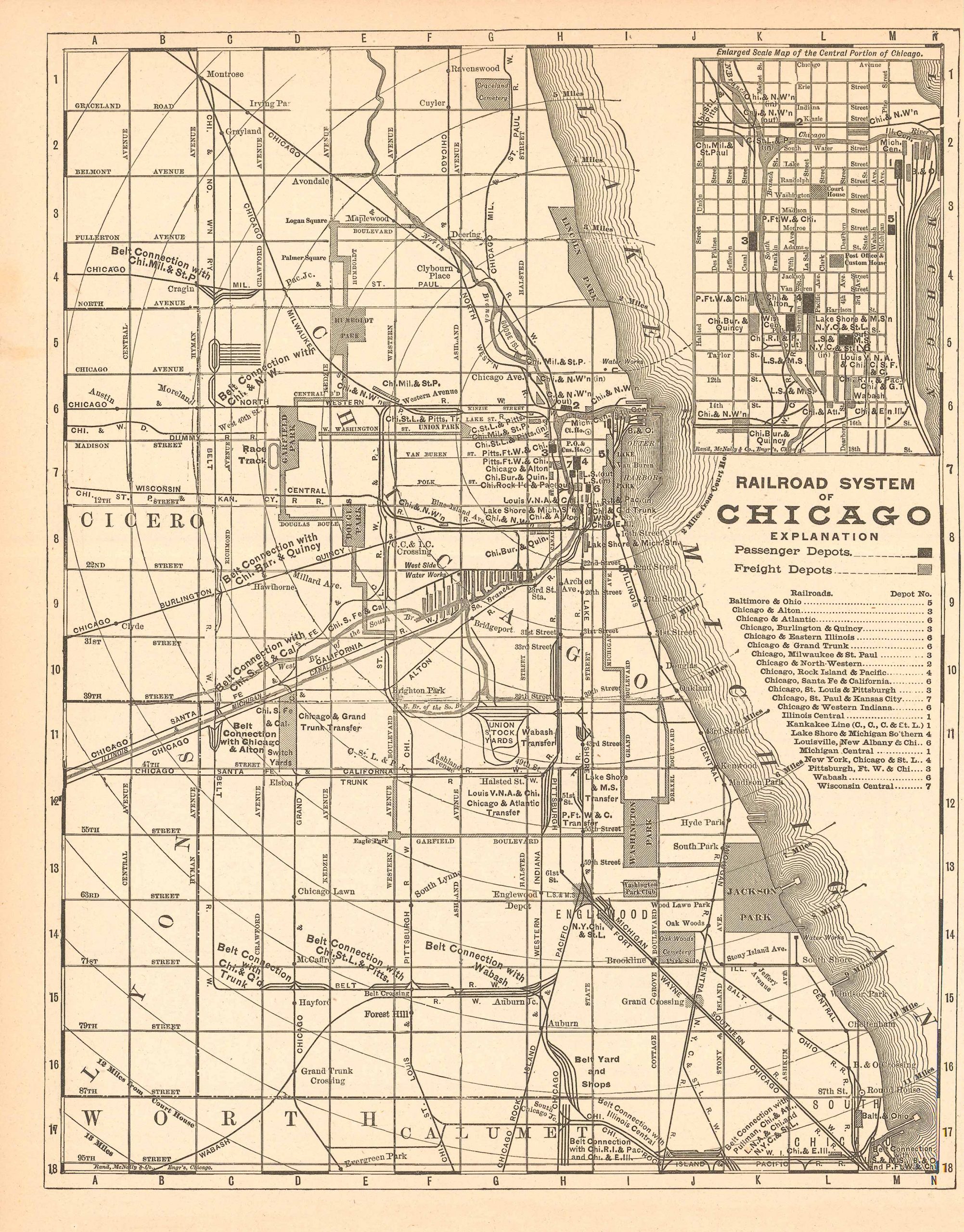
Rand, McNally & Company. McNally's 1891 Map of Chicago. , 1891.
Price: US$85.00 + shipping
Description: We are proud to offer this map of Chicago, originally produced as part of Rand McNally's Enlarged Business Atlas dated 1891. Although the table of contents shows different editions starting in 1885, we believe this is the first edition of the Enlarged Atlas. Each of these maps accurately locates all cities, towns, post offices, railroad stations, villages, counties, parishes, islands, lakes, rivers, mountains and more. Until McNallyâs enlarged Business Atlas, maps had never been produced that provided as much information as these do. Even today, we use these 130 year old maps to locate small towns, villages, and railroad routes that are no more. This map measures 12.75 inches by 9.75 inches.
Seller: Art Source International Inc., Boulder, CO, U.S.A.
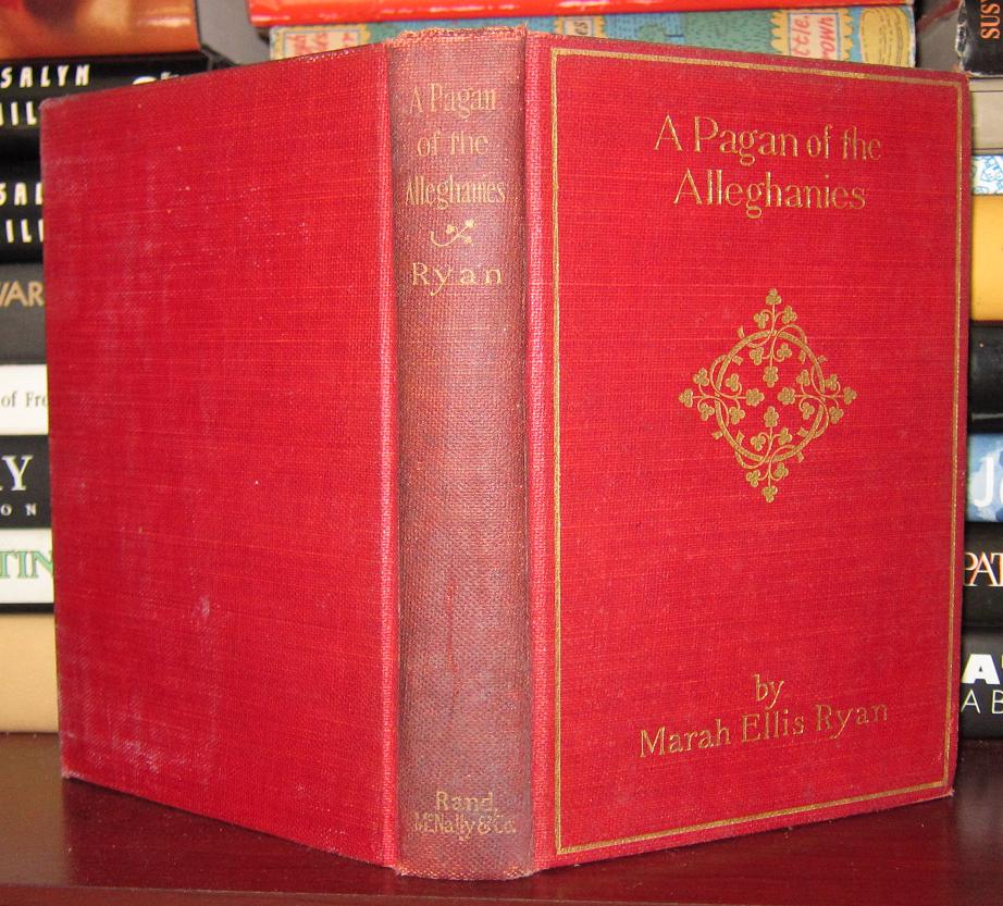
Ryan, Marah Ellis. A PAGAN OF THE ALLEGHANIES. Rand, McNally & Co, Chicago, 1891.
Price: US$85.53 + shipping
Description: Very Good in boards. Owner name. A bright clean copy.
Seller: Rare Book Cellar, Pomona, NY, U.S.A.
Rand, McNally & Company. McNally's 1891 Map of Cuba. , 1891.
Price: US$95.00 + shipping
Description: We are proud to offer this map of Cuba, originally produced as part of Rand McNally's Enlarged Business Atlas, dated 1891. Although the table of contents shows different editions starting in 1885, we believe this is the first edition of the Enlarged Atlas. Each of these maps accurately locates all cities, towns, post offices, railroad stations, villages, counties, parishes, islands, lakes, rivers, mountains and more. Until McNallyâs enlarged Business Atlas, maps had never been produced that provided as much information as these do. Even today, we use these 130 year old maps to locate small towns, villages, and railroad routes that are no more. This map measures 13.25 inches by 19.75 inches.
Seller: Art Source International Inc., Boulder, CO, U.S.A.

Rand McNally. McNally's 1891 Map of Florida. , 1891.
Price: US$95.00 + shipping
Description: We are proud to offer this map of Florida, originally produced as part of Rand McNally's Enlarged Business Atlas dated 1891. Although the table of contents shows different editions starting in 1885, we believe this is the first edition of the Enlarged Atlas. Each of these maps accurately locates all cities, towns, post offices, railroad stations, villages, counties, parishes, islands, lakes, rivers, mountains and more. Until McNally??s enlarged Business Atlas, maps had never been produced that provided as much information as these do. Even today, we use these 130 year old maps to locate small towns, villages, and railroad routes that are no more.The size of the map is 13.25 x 19.75
Seller: Art Source International Inc., Boulder, CO, U.S.A.

Rand, McNally & Company. McNally's 1891 Map of Boston. , 1891.
Price: US$95.00 + shipping
Description: We are proud to offer this map of Boston, originally produced as part of Rand McNally's Enlarged Business Atlas dated 1891. Although the table of contents shows different editions starting in 1885, we believe this is the first edition of the Enlarged Atlas. Each of these maps accurately locates all cities, towns, post offices, railroad stations, villages, counties, parishes, islands, lakes, rivers, mountains and more. Until McNallyâs enlarged Business Atlas, maps had never been produced that provided as much information as these do. Even today, we use these 130 year old maps to locate small towns, villages, and railroad routes that are no more.The map measures 9.8 by 13.25 inches.
Seller: Art Source International Inc., Boulder, CO, U.S.A.
Ingersoll, Ernest. A Week in New York. Rand McNally & Co, New York, 1891.
Price: US$100.00 + shipping
Condition: Very Good
Description: 328pp octavo, illustrated. Last few pages chewed at the lower corner not affecting any of the text nor the covers. Otherwise a very good copy in the rare red cloth covers, seldom found in hard cover and seldom found at all. Included in the rear is the rare foldout map of New York City. Covers spotted near the foredge.
Seller: Old New York Book Shop, ABAA, Atlanta, GA, U.S.A.
Rand-McNally Co.. Rand-McNally & Co.*s Neuer Familien=Atlas der Welt. Rand-McNally, Chicago, 1891.
Price: US$100.00 + shipping
Description: Vintage German-language atlas. Tight binding, no markings. 11-1/4 x 14-1/4, 331 pp, index, color maps, b/w illus (engravings), decorative endpapers, color marbled edges. VeryGood unmarked; cover gilt faded, front cover rubbed, light wear to spine ends, tight binding. Hardcover in cloth decoratively-stamped boards w gilt titling; no jacket.
Seller: Ed Buryn Books, Nevada City, CA, U.S.A.
Price: US$100.00 + shipping
Condition: Very Good
Description: Original publisher's light brown cloth binding with gilt lettering on front cover and spine. Copy of James Strohn Copley. 6" x 8 1/2." 212 pages, complete. Many black-and-white plates and illustrations and one black-and-white folding map, complete. Folding map tipped in back. Six additional pages of advertisements for various books, places, businesses, and services in front. Ads also printed on front and back pastedowns. Some of the places, businesses, or items advertised are "Hotel San Rafael," "The California National Bank," "Windsor European Hotel," "Arrowhead Springs," "The Globe Library," and "The American Book of the Dog." Former owner's black-and-white illustrated bookplate tipped in on front pastedown (partially obscures a San Francisco insurance ad): "James Strohn Copley." James Strohn Copley (1916-1973) was an American journalist and newspaper publisher. He published the San Diego Union and San Diego Evening Tribune, which later merged into the San Diego Union-Tribune. Another former owner's pencil signature in top margin of front pastedown: "Donald Walters." Purple stamp dated 1893 on front free endpaper of the "Railroad News Co." (on Hotel San Rafael ad). Pages and covers are very clean and intact overall. Pages are slightly age-toned. Light foxing limited to front and back endpapers. Covers have light rubbing. Front cover has an almost imperceptible water ring and a couple small scratches. Moderate wear to corners, bottom edge, and head and tail of spine. Slight smoky smell to the book. A Very Good copy. A compendium of histories, travel advice, and scenic descriptions of places in and around Kansas, Colorado, New Mexico, Arizona, and California beautifully accented by detailed illustrations, many of which show natural landscapes. The tour roughly traces the Santa Fe Trail. A brief section on the Texas Panhandle. Also includes points of interest and descriptions of people, nature, and scenery. Appendix in back comprises an Itinerary and list of Spanish Geographical Names.
Seller: Barry Cassidy Rare Books, Sacramento, CA, U.S.A.
. SUPERIOR WISCONSIN Coming Into A Kingdom. Rand McNally: Chicago, 1891.
Price: US$109.25 + shipping
Condition: Very Good
Description: Illus., map on back cover, oblong 5 x 3.25", sewn cream wraps, unpaginated. Covers soiled and creased, lacks tip of a front corner, rear cover torn, contents have light staining and creasing else good. Superior, Wisconsin went through a boom period 1888-1892 (the latest date mentioned is 1890) and the contents are promotional so therefore likely published in 1891. Some of Superior's offerings: Webster Chair Factory, Duff Forge Works, LaBelle Wagon Works, summer resorts, trout fishing, hotels, railroads. SCARCE. Not in NUC or LC.
Seller: John K King Used & Rare Books, Detroit, MI, U.S.A.
Shields O.G. Editor. THE AMERICAN BOOK OF THE DOG. Rand McNally, 1891.
Price: US$115.00 + shipping
Condition: Good
Description: Thick 4to volume in gold embossed leather binding. Front board off with tape residue spine intact but poor condition back board holding. 702 pages + ads in this with very clean contents with no markings.
Seller: Antique Emporium, Eau Claire, WI, U.S.A.
Rand, McNally & Co. Map of Philadelpia (1891). Rand, McNally & Co, 1891.
Price: US$118.75 + shipping
Description: Sheet 21.75 x 29.5 inches, with map 19 x 26 inches. Oblong format. From Rand, McNally & Co.'s Index Atlas of the World, 1891, pp. 90-91. With inset map 'Philadelphia and Vicinity.' Printed in pink, blue, green and yellow. A near fine copy. Map folded once in center. Map shrinkwrapped on foamcore.
Seller: Eureka Books, Eureka, CA, U.S.A.
Rand, McNally & Company. Map of Baltimore (1891). Rand, McNally & Company, 1891.
Price: US$118.75 + shipping
Description: Sheet 21.75 x 29.5 inches with map 19 x 26 inches. Printed in pink, blue and green. With inset 'Map of Baltimore and Environs.' From Rand, McNally & Company's Indexed Atlas of the World, 1891, pp. 102-103. A near fine copy. Map folded in center. Map has been shrinkwrapped on foamcore.
Seller: Eureka Books, Eureka, CA, U.S.A.
Rand, McNally & Co. Map of Oregon (1891). Rand, McNally & Co, 1891.
Price: US$118.75 + shipping
Description: Sheet 21.75 x 29.5 inches with map 19 x 26 inches. From Rand, McNally & Company's Indexed Atlas of the World, 1891, pp. 350-351. Printed in pink, yellow, green, orange delineating the counties. A near fine copy. Map folded once in center. Map is shrinkwrapped and on foamcore.
Seller: Eureka Books, Eureka, CA, U.S.A.
. RAND McNALLY & CO'S NEW FAMILY ATLAS OF THE WORLD. Rand McNally, Chicago, 1891.
Price: US$125.00 + shipping
Condition: Very Good
Description: Brown decorative cloth binding; 338pp. Maps, charts, etc.from p.3-237. No name or writing. CLEAN!
Seller: Terra Firma Books, San Diego, CA, U.S.A.
Ingersoll, Ernest:. A week in New York.. New York, Rand McNally,, 1891.
Price: US$131.87 + shipping
Description: With numerous illustrations in the text and on plates and a large folding map, 328 p. The folding map of New York city includes Brooklyn, Jersey City, Westchester Co. (Manhattan in large scale and the southern part of Manhattan separately), Book block slightly warped, previous owners stamp on title, folding map slightly torn, otherwise fine copy. Sprache: Englisch Gewicht in Gramm: 0 Small-8°, contemporary cloth binding.
Seller: Buch & Cafe Antiquarius, Bonn, NRW, Germany

Price: US$140.00 + shipping
Condition: Very Good
Description: pp: 136, (4) ads. Full-color map opens to 21" x 28"; faint dampmark at margins, not affecting map. Folds into brown stiff wrappers, printed in black, with view of Phoenix Hotel on back cover. 6.5" x 4"
Seller: R & A Petrilla, IOBA, Roosevelt, NJ, U.S.A.

. Railroad Map of Illinois. Rand McNally, Chicago, 1891.
Price: US$145.00 + shipping
Condition: Very Good
Description: Blue cloth boards with title label. Lightly rubbed corners and a scratched area on title label. The hand-colored rail map, keyed by individual railway, is in very good condition. Contains an inset map of Chicago. ; 25 1/2" x 20 1/2"
Seller: Back of Beyond Books, Moab, UT, U.S.A.

Price: US$150.00 + shipping
Condition: Very Good
Description: As Rand McNally assumed its role as a global leader in map publication near the end of the 19th century, it's unsurprising to see the company produced its popular atlases in multiple languages. This example, Neuer Familien Atlas Der Welt (New Family Atlas of the World), was issued in 1891 and includes German text alongside the original maps in English. It features detailed color lithographed maps of the United States and the world, in addition to thematic graphs, comparison charts, portraits of historical figures and flags of important nations. Sheet Width (in) 11 Sheet Height (in) 14 Condition Description The atlas is in good condition. Original broad cloth boards are present, but rubbed with a faded title. Spine is also tattered and loose with old tape repairs along the front cover. Missing the title page, but otherwise the contents are complete and in good shape. A few sheets show minor discoloration, small tears or faint water stains. 331 pages including 160 pages of single and double page color lithographed maps, charts and diagrams.
Seller: Curtis Wright Maps, Berwyn, IL, U.S.A.

G. O. Shields ("Coquina"). The American Book of the Dog. Rand McNally & Company, 1891.
Price: US$160.00 + shipping
Condition: Fair
Description: Square and solid in original half-bound maroon leather and gilt-decorated cloth. Banded backstrip with gilt lettering and edging shows significant edgewear and very top part is worn off. Corner leather also shows some edgewear. Endpapers are marbled with previous owner's bookplate on front pastedown and previous owner's stamp on front endpaper. Text block is complete and unmarked with front hinge just beginning. 702 pages plus extensive ads. More photos available upon request. Will be carefully packaged and shipped with tracking and insurance. Size: 8vo - over 7¾" - 9¾" tall
Seller: Dogtales, Copake, NY, U.S.A.
Price: US$225.00 + shipping
Condition: Very Good
Description: Pub by Rand, McNally & Co., 1891, same date TP & CP, NAP, presumed 1st Edition. NOT exLib. VG+ or better cond. hardcover, no dj. Original dark brown leather over beveled bds w/ bright gilt pict dec & lettering in bright gilt on front cover, a.e.g. Matching leather backstrip, no lettering, by professional bookbinder. Gold marbled eps w/ hinges professionally reinforced. Book is complete, intact & unmarked, & internally virtually as-new. Illustrated in b&w. 702pp + 18pp publisher's advts. Square, straight, tight, bright & clean, overall VG+ or better cond. Same or next day shipping. Please email any questions
Seller: Rivertown Fine Books, McGregor, IA, U.S.A.

Price: US$250.00 + shipping
Condition: Fair
Description: A rare find.a World Atlas from the 1800's in German. Size: Folio - over 12" - 15" tall. 331 pp. Text is in German. Pages are yellowed, but are clean. Spine is cracked and binding is loose, but intact. Previous owner's inscription on endpapers. Heavy shelfwear to the cover. Bumped and rubbed. Corners are rounded. Quantity Available: 1. Shipped Weight: Over 6 pounds. Category: Travel & Places; German Language; Pictures of this item not already displayed here available upon request. Inventory No: 001669. Additional shipping charges may apply.
Seller: Lotzabooks, Oak Point, TX, U.S.A.
Price: US$365.00 + shipping
Description: Wonderful antique atlas w fascinating statistical illustrations & charts, biographical section with portraits & signatures of signers of Declaration of Independence & US Presidents, description of each state, b/w engravings of various city views, plus 160 pages of outstanding color maps of the world in 1891, all in clean crisp condition. Text portions are in German language (old German text) but all maps are in English. Rare and fascinating offering. 11-1/4 x 14-1/4, 331 pp, place index, color maps, b/w illus, decorated endpapers. Very Good overall, unmarked, in Good boards w light wear to spine ends, faded titling, spotted front board; binding is tight. Oversize Hardcover in maroon cloth boards w gilt titling, embossed designs on front & back boards, all edges marbled. German edition of the Rand McNally New Standard Atlas of 1890.
Seller: Ed Buryn Books, Nevada City, CA, U.S.A.

Price: US$450.00 + shipping
Condition: Very Good
Description: Folding frontispiece plan of the inner city + 510 pages + (1) city plan showing the burned district of the Chicago Fire + (1) blank + 48 pages concerning the Suburban Stations, ports, cable rates, growth statistics, street railways & other city data + (4) page Index + lx pages of city advertisements, often illustrated and printed on yellow-tinted paper + (7) pages of Addresses for Purchasers, Physicians, Foreign Consuls. Final free endpaper with chart of Railroad Ticket Offices, Passenger and Freight Depots; attached at back endpaper is a "Rand, McNally & Co.'s Map of Chicago. No. 3 1891" - 22 1/2" x 30 1/2" approx. size, printed in colors; the reverse is a slightly smaller Rand McNally New City Limits Map of Chicago 1891 (with printed copyright date of 1889). Illustrated throughout in black and white, with some of these double-folds; there are additional illustrations of city architecture & environs printed on heavier paper stock, made from photographs. A thorough guide, with sections on how to reach Chicago, living & touring the area; city, federal, educational institutions, businesses, the press, churches & religious institutions, cemeteries, commercial exchanges, cultural activities and groups and much on transportation including routes & schedules in and around the city. Schick's prefatory comments allude to arranging a future edition with expanded coverage; however, the Newberry Library, in their Foreign Language Press Survey notes his Illinois Staats-Zeitung of November 25, 1892 obituary: " the well-known German publisher died last Wednesday morning at 177 Illinois St. from heart disease. Louis Schick was born in 1842 in Hamburg v. d. Hohe, Germany. His father was likewise a publisher, and he came from an old established publishing house. Schick came to America at the age of 17, and to Chicago in the early sixties. Here he entered a business house as a clerk and worked himself up to the position of bookkeeper. Later he established, with a Mr. Meininger, a German bookshop on Madison St. The Chicago fire destroyed his business. After the fire he started another German bookstore on the corner of Clark and Lake Sts. This business he retained until he retired in 1889, in order to devote his time entirely to publications. His collection of novels, known as the Schick Collection, and his Humoristic Library are well known everywhere. He also published a splendid translation of Nordau's Works: Conventional Lies and Paradoxes. He is also the author and publisher of, Chicago and Its Environs. Schick lived a rather secluded life during his last years. Nature was his best friend. He was never married. A sister, living in Chicago, survives him." The title page with the small partial previous owner name-stamp of collector George R. Brush M.D. U.S. Navy; a surgeon & medical inspector, from 1861-1894. Approx. 5" x 7" size; bound in flexible red cloth, gilt cover and spine titles (dulled). Some edge-wear and mottling of color to the cloth; front bottom corner bumped, the "push' of the paper in the corner carrying through the volume. Contents clean and in very good condition.
Seller: Certain Books, ABAA, Bolivia, NC, U.S.A.

Rand McNally. New Eight-Inch Terrestrial Globe. Chicago, Chicago, 1891.
Price: US$1000.00 + shipping
Description: Small globe, generally in excellent condition. Original tripod heavy metal stand, lacking hardware at top. Minor loss from adhesion, with very small areas missing in Russia and near Greenland, with very small blemishes elsewhere. Some darkening from age.
Seller: High Ridge Books, Inc. - ABAA, South Deerfield, MA, U.S.A.