Available Copies from Independent Booksellers

Price: US$1500.00 + shipping
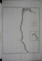
Description: An inset map of Fort Stewert appears on the right hand side of the map.[George Vancouver (1758-1798) served as an officer in the second and third voyages of James Cook (1772-4, 1776-80) and as a seasoned sailor and established surveyor was placed in command of an expedition to the Northwest Coast to determine England?s rights under the Nootka Sound convention of 1790. He left the British Isles in 1791 and sailed via Cape of Good Hope to Australia, where he made a survey of the southwest coast and New Zealand, to Tahiti and Hawaii. In April 1792, Vancouver left Hawaii and sailed to the Californian coast. He reached the Northwest Coast in 1792 and spent two years surveying the coastline, resulting in the most correct maps of the Northwest made up to that time. Vancouver?s explorations on the northwest coast included the Port of San Francisco, New Albio, Nootka Sound, and the Straits of Juan de Fuca., Size : 745x610 (mm), 29.25x24 (Inches), Black & White
Seller: Alexandre Antique Prints, Maps & Books, Toronto, ON, Canada
Price: US$2500.00 + shipping
Description: A small inset map appears along the right margin[George Vancouver (1758-1798) served as an officer in the second and third voyages of James Cook (1772-4, 1776-80) and as a seasoned sailor and established surveyor was placed in command of an expedition to the Northwest Coast to determine England?s rights under the Nootka Sound convention of 1790. He left the British Isles in 1791 and sailed via Cape of Good Hope to Australia, where he made a survey of the southwest coast and New Zealand, to Tahiti and Hawaii. In April 1792, Vancouver left Hawaii and sailed to the Californian coast. He reached the Northwest Coast in 1792 and spent two years surveying the coastline, resulting in the most correct maps of the Northwest made up to that time. Vancouver?s explorations on the northwest coast included the Port of San Francisco, New Albio, Nootka Sound, and the Straits of Juan de Fuca., Size : 750x610 (mm), 29.5x24 (Inches), Black & White
Seller: Alexandre Antique Prints, Maps & Books, Toronto, ON, Canada