Available Copies from Independent Booksellers
Price: US$283.42 + shipping
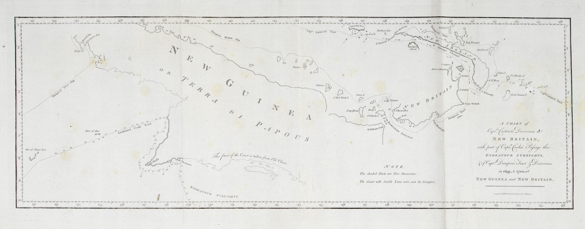
Description: London: Strahan & Cadell, 1773. Coloured. 245 x 645mm. Another one of Cook's achievements on his First Voyage was the confirmation that Torres Strait separated New Guinea and Australia, although Cook had expresssed doubt that it existed himself. This chart marks the southern coastline he verified, with the rest of the outline taken from earlier explorers. To the north of the island are the tracks of Dampier and Carteret around New Britain and New Ireland. Engraved by W.Whitchurch for Hawkesworth's important work 'An Account of the Voyages. for making Discoveries in the Southern Hemisphere', the official account of Cook's First Voyage.
Seller: Altea Antique Maps, London, United Kingdom

Price: US$4000.00 + shipping
Description: Quartos, volumes one and three only. In Very Good condition. Bound in contemporary calf, later rebacking with new spine. Spine with gilt lettering and tooling. Some light wear and rubbing to bindings. Bookplate to front pastedowns. Volume three with water-stains to upper gutter on pages 49-76 and upper and lower gutter from page 360-end. With all plates and maps in the two volumes as called for. Some folding plates with small tears near gutter. PS consignment. Shelved case 9. ESTC: T74467. A reissue of the first edition, with an additional gathering of four leaves inserted with the drop-head title 'Preface to the second edition'. James Cook led three voyages through Oceania from 1768-1780, with the first voyage lasting from 1768 to 1771. The aims of this first expedition were twofold, being to observe the 1769 transit of Venus across the Sun, and to seek evidence of the then unknown but hypothesized Terra Australis Incognita. The expedition was the second European voyage to reach New Zealand (and the first in 127 years) and the first known Europeans to reach the east coast of Australia. This second edition came out in August 1773. The first volume details John Byron's account of the 1764-1766 voyage of HMS Dolphin, Samuel Wallis' journal of the 1766-1768 voyage of the same ship that included the first European encounter with Tahiti, and Philip Carteret's 1766-1769 circumnavigation on HMS Swallow, where some islands including Pitcairn Island were found. The second and third volume concern the first voyage of James Cook, The second volume, lacking here, focuses largely on Tahiti and the transit of Venus. The third volume focuses on New Zealand and the east coast of Australia. 1369017. Shelved Dupont Bookstore.
Seller: Second Story Books, ABAA, Rockville, MD, U.S.A.
Price: US$5038.50 + shipping
Condition: Very Good
Description: Cook's First Voyage. 3 vols. 4to. modern full black leather gilt, blindstamped raised bands (new endpapers, some toning and marking, bound without half-titles, leaf edges a little thumbed, occ. misfolding to plans and charts, marginal tear to final leaf with only slight loss, occ. pencil marginalia, else generally clean and neat); pp. [xii (last blank)], xxxvi, [iv ('Directions for Placing the Cuts and Charts', last blank), 1-39, 360-676, with folding frontispiece + 19 other views, charts and plates (many folding, lacks 'Chart of the Streight of Magellan', as is usual in the first edition); xvi (last errata), 1-410 (last blank), with 21 views, charts and plates (lacks 'Chart of Cook's Streight in New Zealand'); vi (last errata), 411-800 (last blank), with 9 views, charts and plates; Very heavy set (7 kg), additional postage may be required for international and domestic delivery. A very good copy in a new binding. (Holmes, 3). Ex-libris Charles Scobie (ANARE, Macquarie Island, 1948), with his ownership signature dated 19-9-41 to first volume and his occasional pencil marginalia.
Seller: Arapiles Mountain Books - Mount of Alex, Castlemaine, VIC, Australia
Price: US$7085.45 + shipping
Condition: Very Good
Description: An account of the voyages undertaken by the order of his present Majesty for making discoveries in the Southern Hemisphere, and successively performed by Commodore Byron, Captain Wallis, Captain Carteret, and Captain Cook, in the Dolphin, the Swallow, and the Endeavour: drawn up from the journals which were kept by the several commanders, and from the papers of Joseph Banks, Esq; by John Hawkesworth, Ll.D. in three volumes. Illustrated with cuts, and a great variety of charts and maps relative to countries now first discovered, or hitherto but imperfectly known. London: W. Strahan and T. Cadell, 1773 -1773 -Published in London by W Strahen and T Cadell -True 1st Edition of Hawkesworth's edition of Cook's first voyage. The page numbering of the volumes distinguishes the two editions. In the first volume numbers skip from 139 to 360. Page numbering continues between the 2nd and 3d volumes, as these were originally planned to be bound as one. This numbering is corrected in the more common 2nd edition. [xii]; xxxvi; 1-139, 360-676; Vol. II pp. xv; [i]; 410, Vol. III pp. [vi]; 411 - 799 -Complete text and 51 (of 51) plates. Early 1st edition therefore strait of Magellen chart not called for (this chart is found in 2nd editions). I can include a separate copy of this map if desired. -Original calf binding rebacked (retaining original labels) in very good condition -Book plate of John Tremayne of Heligan House, Cornwall. -Interior good, but some toning to pages and plates. -Includes the important folding charts of New Zealand and the East Coast of Australia, and the Engravings of a Kangaroo and NZ Maori warrior. These landmark voyages were the first to accurately map the pacific and included the first European mapping of Tahiti, New Zealand and the East Coast of Australia. Cook's voyage was a triumph of navigation and changed the face of the Pacific, paving the way for the further European exploration and the modern Pacific.
Seller: De Bry Rare Books, Oxford, United Kingdom

Price: US$7500.00 + shipping
Description: 4to. This is the first printing, first state, of the famous account of what is now described as 'Cook's First Voyage', although primary credit for the creation of this account is given to John Hawkesworth (who had been commissioned by the Admiralty to edit Capt. Cook's papers). Note: there was a second edition published in the same year, containing a Preface by Hawkesworth (Beddie 650). Volume I of our offering ends at page 676, and shows page 139 as numbered 139-360 (as called for in Beddie 648). It contains 18 of the 21 charts and plates called for in this volume, lacking two charts and one plate (or 'cut' as it is called). Volume II has a large tide mark across the top of the first third, or so, of the contents. Page 189 is misnumbered 191. Old worm hole to margins of pages 119-161. Contains 16 of 22 charts and plates (five folding charts, seven folding plates, and four single page plates). The text is complete in 410 numbered pages. Volume III text commences at page 411 and concludes at page 795. All nine plates and charts are present, including the very large folding chart of New Zealand (Cook was the first to confirm that New Zealand was, in fact, an island). Lack of nine plates/ charts. The text shows foxing, severe on a few pages but, on the whole, the text is perfectly readable and, if professionally restored, the plates and charts would be magnificent.
Seller: BISON BOOKS - ABAC/ILAB, Winnipeg, MB, Canada

Price: US$9723.04 + shipping
Description: 4to. Pp. (xii), xl, (8), 456; xiv, 410; 395. With 52 engraved plates and maps, many folding. One leaf repaired at lower margin, slight loss of text. Attractively bound in speckled calf, spines with five raised bands, richly decorated, with red and green morocco title labels, marbled end papers. (By G. Hedberg at the beginning of 20th century). Copy of Ericsberg castle, Sweden. Second, considered the best, edition of Cook's first voyage during the years 1768-71. The aim of the expedition was to observe the "Transit of Venus" at Tahiti and secondly to search for a Great Southern Continent. The expedition entered the Pacific around Cape Horn and sailed to Tahiti where the observations of the Venus were made, then the voyage continued to the Society Islands, and after that New Zealand was explored and also the eastern coast of Australia (New South Wales). Hawkesworth's account was an immediate success and aroused much interest in the Pacific throughout Europe. Captain Cook was promoted to the rank of Commander, and in the following year he set out in command of the Resolution heading once more to the Pacific. The first volume of Hawkesworth account covers the voyages by John Byron , Captain Wallis and Captain Carteret. Cf Hill (2004) 782 & 783.
Seller: Charlotte Du Rietz Rare Books (ILAB), Stockholm, Sweden

Price: US$32206.57 + shipping
Description: A complete set of the official accounts of Cook's three Pacific voyages, all second editions; attractively presented in a uniform binding. "Captain Cook's three great voyages form the basis for any collection of Pacific books. In three voyages Cook did more to clarify the geographical knowledge of the southern hemisphere than all his predecessors had done together. He was the first really scientific navigator and his voyages made great contributions to many fields of knowledge" (Hill). His contributions to the advancement of knowledge were widely recognized in his own time. Cook's many discoveries resulted in British claims in Alaska, British Columbia, Oregon, Australia, New Zealand, and Hawaii, the last of which he regarded as his most valuable discovery but where he met his death. "Cook earned his place in history by opening up the pacific to western civilization and by the foundation of British Australia. The world was given for the first time an essentially complete knowledge of the Pacific Ocean and Australia, and Cook proved once and for all that there was no great southern continent, as had always been believed. He also suggested the existence of antarctic land in the southern ice ring, a fact which was not proved until the explorations of the nineteenth century" (PMM). - First voyage: HAWKESWORTH, John. An Account of the Voyages Undertaken by the Order of His Present Majesty for Making Discoveries in the Southern Hemisphere, and Successively Performed by Commodore Byron, Captain Wallis, Captain Carteret and Captain Cook. London: W. Strahan and T. Cadell, 1773. Second edition. The primary purpose of Cook's first voyage in Endeavour was the observation of the transit of Venus from Tahiti, and then to continue the enterprise of geographical investigation begun by Commodore Byron. This was to result in the discovery of the Society Islands, the circumnavigation of New Zealand, and the charting of the eastern coast of Australia. "Hawkesworth, an eminent London author, was chosen by Lord Sandwich and commissioned by the Admiralty to prepare these narratives for publication. [He] was expected to add polish to the rough narratives of sea men, and to present the accounts in a style befitting the status of the voyages as official government expeditions, intended to embellish England's prestige as a maritime power" (ODNB). Hawkesworth "secured from Strahan and Cadell the huge sum of £6,000 for the rights of publication, more than was paid for any other literary work of the century. This staggering figure soon became common knowledge, and indignation and resentment that Hawkesworth should get so much for fashioning the work of other people were a main ingredient in the hostile reception of the work" (Edwards, p. 85) The second edition, following the first of the same year, includes a new preface by Hawkesworth in reply to a letter from Alexander Dalrymple and is sometimes preferred for that reason; in addition, the second and third volumes are separately paginated - in the first edition pagination was continuous across those volumes. - Second voyage: COOK, James, 1728-1779. A Voyage towards the South Pole, and Round the World. Performed in His Majesty's Ships the Resolution and Adventure, In the years 1772, 1773, 1774, and 1775. London: Printed for W. Strahan; and T. Cadell, 1777. Second edition. The fame Cook had achieved by his first voyage allowed him to write the account of the second himself. It is the only one of the three voyages written directly by Cook, as the first was authored by Hawkesworth, and the third was published after Cook's death and derived from his journals. Historically, the second voyage is his most important expedition, conducted in search of the great "Terra Australis", a great southern landmass. In the course of the voyage he visited Easter Island, the Marquesas, Tahiti, the Society Islands, Niue, the Tonga Islands, the New Hebrides, New Caledonia, Norfolk Island, Palmerston Island, South Sandwich Islands, and South Georgia, many of which he named in the process. Cook proved the "Terra Australis" to be a myth, and predicted Antarctic land beyond the ice barrier. In addition to the geographical, botanical and other cultural discoveries of the voyage, Cook also deals with the organizational problems of an expedition on such a large scale: he was "probably the first sea captain to realize the importance of preserving the health and well-being of his crew" (PMM). Cook's account is also noted for its illustrations, "of very high artistic quality" (Rosove), mostly after drawings and paintings by young artist William Hodges (1744-1797). - Third voyage: COOK, James, & James King. A Voyage to the Pacific Ocean Undertaken by the Command of His Majesty, for Making Discoveries in the Northern Hemisphere. London: Printed by H. Hughs, for G. Nicol and T. Cadell, 1785. Second edition, published a year after the first, of Cook's fatal third voyage, an attempt to find a north-west passage, which led to a first and finally lethal encounter with the Hawaiian Islands. The third voyage was distinguished for the extent and importance of its discoveries. Alongside the discovery of Hawaii and several smaller islands, Cook charted the Pacific coast from northern California to the Bering Strait, much of which was formerly unknown. The voyage thereby "depicted accurately for the first time the north-west coast of America, leaving no major discoveries for his successors. In addition the scientific discoveries in the fields of natural history and ethnology were considerable and the drawings made by the artists were of great significance" (ODNB). The text was edited by Dr John Douglas from Cook's journals, and continued after his death from the journals of Captain King. The second edition has long been considered the best; the title pages are enhanced by the addition of vignettes of Cook's Royal Society medal and a portrait medal of Captain King, and the text was entirely reset. Forbes points ou
Seller: Peter Harrington. ABA/ ILAB., London, United Kingdom
Price: US$48309.86 + shipping
Description: A complete set of the official accounts of Cook's three Pacific voyages, the second voyage in the first edition, the first and third voyages in the often-preferred second editions. "Captain Cook's three great voyages form the basis for any collection of Pacific books. In three voyages Cook did more to clarify the geographical knowledge of the southern hemisphere than all his predecessors had done together. He was the first really scientific navigator and his voyages made great contributions to many fields of knowledge" (Hill). His contributions to the advancement of knowledge were widely recognized in his own time. Cook's many discoveries resulted in British claims in Alaska, British Columbia, Oregon, Australia, New Zealand, and Hawaii, the last of which he regarded as his most valuable discovery but where he met his death. "Cook earned his place in history by opening up the pacific to western civilization and by the foundation of British Australia. The world was given for the first time an essentially complete knowledge of the Pacific Ocean and Australia, and Cook proved once and for all that there was no great southern continent, as had always been believed. He also suggested the existence of antarctic land in the southern ice ring, a fact which was not proved until the explorations of the nineteenth century" (PMM). This set includes some noteworthy and interesting additions: proofs before letters of "A Man of Van Diemen's Land" and "A Woman of Van Diemen's Land", in strong dark impressions, beautifully inked, both in the first volume of the third voyage, with the captioned plates also present in the atlas volume. Bound as a frontispiece in the first volume of the third voyage is the stipple engraved portrait of Cook by Francesco Bartolozzi after John Webber, published separately in June 1784. - First voyage: HAWKESWORTH, John. An Account of the Voyages Undertaken by the Order of His Present Majesty for Making Discoveries in the Southern Hemisphere, and Successively Performed by Commodore Byron, Captain Wallis, Captain Carteret and Captain Cook. London: W. Strahan and T. Cadell, 1773. Second edition. The primary purpose of Cook's first voyage in Endeavour was the observation of the transit of Venus from Tahiti, and then to continue the enterprise of geographical investigation begun by Commodore Byron. This was to result in the discovery of the Society Islands, the circumnavigation of New Zealand, and the charting of the eastern coast of Australia. "Hawkesworth, an eminent London author, was chosen by Lord Sandwich and commissioned by the Admiralty to prepare these narratives for publication. [He] was expected to add polish to the rough narratives of sea men, and to present the accounts in a style befitting the status of the voyages as official government expeditions, intended to embellish England's prestige as a maritime power" (ODNB). He was paid £6,000 for his labours. The second edition, following the first of the same year, includes a new preface by Hawkesworth in reply to a letter from Alexander Dalrymple and is sometimes preferred for that reason; in addition, the second and third volumes are separately paginated - in the first edition pagination was continuous across those volumes. - Second voyage: COOK, James, 1728-1779. A Voyage towards the South Pole, and Round the World. Performed in His Majesty's Ships the Resolution and Adventure, In the years 1772, 1773, 1774, and 1775. London: Printed for W. Strahan; and T. Cadell, 1777. First edition. The fame Cook had achieved by his first voyage allowed him to write the account of the second himself. It is the only one of the three voyages written directly by Cook, as the first was authored by Hawkesworth, and the third was published after Cook's death and derived from his journals. Historically, the second voyage is his most important expedition, conducted in search of the great "Terra Australis", a great southern landmass. In the course of the voyage he visited Easter Island, the Marquesas, Tahiti, the Society Islands, Niue, the Tonga Islands, the New Hebrides, New Caledonia, Norfolk Island, Palmerston Island, South Sandwich Islands, and South Georgia, many of which he named in the process. Cook proved the "Terra Australis" to be a myth, and predicted Antarctic land beyond the ice barrier. In addition to the geographical, botanical and other cultural discoveries of the voyage, Cook also deals with the organizational problems of an expedition on such a large scale: he was "probably the first sea captain to realize the importance of preserving the health and well-being of his crew" (PMM). Cook's account is also noted for its illustrations, "of very high artistic quality" (Rosove), mostly after drawings and paintings by young artist William Hodges (1744-1797). - Third voyage: COOK, James, & James King. A Voyage to the Pacific Ocean Undertaken by the Command of His Majesty, for Making Discoveries in the Northern Hemisphere. London: Printed by H. Hughs, for G. Nicol and T. Cadell, 1785. Second and generally preferred edition, a year after the first, of Cook's fatal third voyage, an attempt to find a north-west passage, which led to a first and finally lethal encounter with the Hawaiian Islands. The third voyage was distinguished for the extent and importance of its discoveries. Alongside the discovery of Hawaii and several smaller islands, Cook charted the Pacific coast from northern California to the Bering Strait, much of which was formerly unknown. The voyage thereby "depicted accurately for the first time the north-west coast of America, leaving no major discoveries for his successors. In addition the scientific discoveries in the fields of natural history and ethnology were considerable and the drawings made by the artists were of great significance" (ODNB). The text was edited by Dr John Douglas from Cook's journals, and continued after his death from the journals of Captain King. The second edition has long been considered the bes
Seller: Peter Harrington. ABA/ ILAB., London, United Kingdom

COOK, Capt. James. THE THREE VOYAGES OF CAPTAIN JAMES COOK.. , 1773.
Price: US$56000.00 + shipping
Condition: Near Fine
Description: THE THREE VOYAGES OF CAPTAIN JAMES COOK. COOK, Capt. James (1728-1779) Published London 1773-1785. (1785) ALL FIRST EDITIONS OF COOKS THREE VOYAGES PLUS ATLAS & Kippis Life of Captain James Cook, Cook, James. Set of all three voyages, all in first editions, and a uniformly bound copy of the first edition of Kippis LIFE. Atlas recently bound in period full calf. ATLAS, 2 large folding charts & 61 plates with nearly all the original tissue guards in place. Recently bound in full calf expertly executed to match the text vols. A near fine set. Together 8 vols. text, med. 4to, & folio atlas with original tissues. In all 202 fine, engraved maps, charts, portraits, costume plates, views, etc.; the text volumes uniformly re-backed in contemporary style, First Voyage: AN ACCOUNT OF THE VOYAGES UNDERTAKEN BY ORDER OF HIS PRESENT MAJESTY FOR MAKING DISCOVERIES IN THE SOUTHERN HEMISPHERE, AND SUCCESSIVELY PERFORMED BY COMMODORE BYRON, CAPTAIN WALLIS, CAPTAIN CARTERET AND CAPTAIN COOK, IN THE DOLPHIN, THE SWALLOW AND THE ENDEAVOUR: DRAWN UP FROM THE JOURNALS WHICH WERE KEPT BY THE SEVERAL COMMANDERS, AND FROM THE PAPERS OF JOSEPH BANKS, ESQ; BY JOHN HAWKESWORTH, LL.D. IN THREE VOLUMES. ILLUSTRATED WITH CUTS, AND A GREAT VARIETY OF CHARTS AND MAPS RELATIVE TO COUNTRIES NOW FIRST DISCOVERED, OR HITHERTO BUT IMPERFECTLY KNOWN. London: Printed for W. Strahan; & T. Cadell in the Strand. M DCC LXXIII. 3 vols., 4to. First Edition; Vol. I, pp. [xii], xxxvi, 140(last blank), [361]-676; 21 charts & plates (mostly folding); Vol. II, pp. xvi, 410; 22 charts & plates (mostly folding); Vol. III, pp. [vi], 411-800 (last blank); 9 charts & plates (mostly folding); contemporary full speckled calf (neatly re-backed, see below); some occasional spotting and offsetting from plates, but a very good, generally clean set. The first edition, without the later added chart of the Streights of Magellan, and with the Directions for Placing the Cuts added at end. Second Voyage: A VOYAGE TOWARDS THE SOUTH POLE AND ROUND THE WORLD. PERFORMED IN HIS MAJESTY'S SHIPS THE RESOLUTION AND ADVENTURE, IN THE YEARS 1772, 1773, 1774, AND 1775. WRITTEN BY JAMES COOK, COMMANDER OF THE RESOLUTION. IN WHICH IS INCLUDED, CAPTAIN FURNEAUX'S NARRATIVE OF HIS PROCEEDINGS IN THE ADVENTURE DURING THE SEPARATION OF THE SHIPS. IN TWO VOLUMES. ILLUSTRATED WITH MAPS AND CHARTS, AND A VARIETY OF PORTRAITS OF PERSONS AND VIEWS OF PLACES, DRAWN DURING THE VOYAGE BY MR. HODGES, AND ENGRAVED BY THE MOST EMINENT MASTERS. London: Printed for W. Strahan; and T. Cadell in the Strand. MDCCLXXVII. 2 vols., 4to. First Edition; Vol. I, pp. xl, 378; portrait frontis., 36 charts & plates; Vol. II, pp. [viii], 396; 27 charts and plates; 2 plates and 2 charts with imprints cropped or shaved by the binder (as often, binders had to trim the large plates to fit them in); contemporary full speckled calf (neatly rebacked, see below); a very good, clean set. Third Voyage: A VOYAGE TO THE PACIFIC OCEAN. UNDERTAKEN BY THE COMMAND OF HIS MAJESTY, FOR MAKING DISCOVERIES IN THE NORTHERN HEMISPHERE. TO DETERMINE THE POSITION AND EXTENT OF THE WEST SIDE OF NORTH AMERICA; ITS DISTANCE FROM ASIA; AND THE PRACTICABILITY OF A NORTHERN PASSAGE TO EUROPE. PERFORMED UNDER THE DIRECTION OF CAPTAINS COOK, CLERKE, AND GORE, IN HIS MAJESTY'S SHIPS THE RESOLUTION AND DISCOVERY; IN THE YEARS 1776, 1777, 1778, 1779, AND 1780. IN THREE VOLUMES. VOL. I. AND II. WRITTEN BY CAPTAIN JAMES COOK, F.R.S. VOL. III. BY CAPTAIN JAMES KING, LL.D. AND F.R.S. ILLUSTRATED WITH MAPS AND CHARTS, FROM THE ORIGINAL DRAWINGS MADE BY LIEUT HENRY ROBERTS, UNDER THE DIRECTION OF CAPTAIN COOK; AND WITH A GREAT VARIETY OF PORTRAITS OF PERSONS, VIEWS OF PLACES, AND HISTORICAL REPRESENTATIONS OF REMARKABLE INCIDENTS, DRAWN BY MR. WEBBER DURING THE VOYAGE, AND ENGRAVED BY THE MOST EMINENT ARTISTS. PUBLISHED BY ORDER OF THE LORDS COMMISSIONERS OF THE ADMIRALTY. London: Printed by W. and A. Strahan: For G. Nicol, Bookseller to His Majesty, in the Strand; and T. Ca
Seller: E.C. Rare Books., Vancouver, BC, Canada

Price: US$57500.00 + shipping
Condition: Very Good
Description: Ten volumes, (nine quarto volumes plus one folio atlas volume) all bound uniformly in contemporary tree calf with elaborately gilt-decorated spines with raised bands and red and green morocco spine labels interspersed with gilt stamped image of Cook's ship the Endeavour or Resolution. Volumes have been expertly re-backed. Light rubbing to leather on board edges with some abraded areas. Overall text, plates and maps are quite clean with occasional foxing and a rare small chip or tear to edges of pages. Plate XLII in volume II has a minor closed tear. One plate in atlas volume shows an archival repair, expertly rendered. One leaf in volume 1 missing 3/4" piece from edge. Three volumes from the 3rd Voyage have extra-wide margins. Trimming to several plates is a little tight to plate margins but no content loss was observed. Within several of the folding maps are very small blemishes at folds, not affecting content. Set includes the scarce first edition of the first voyage by Hawkesworth, the second edition of Cook's official report of the second voyage and finally the second edition of the third voyage by Cook and James King. Superbly illustrated with more than 200 engraved charts, maps and plates many of which are folding. All in all, this is an outstanding set with exceptional and handsome bindings and clean interiors. A high point for any book collection on world exploration. James Cook embarked on three circumnavigations between 1768 and 1776 leaving a legacy of reliable maps of most of the Pacific Ocean and the western coast of North America. The official accounts of the three voyages were eagerly sought by a curious public with early editions selling quickly and leading to an amazing array of sets consisting of various editions and collations. The 1773 first edition Hawkesworth volume is accompanied by 52 charts and plates. According to Sabin (30934) , the first edition is preferred for its plates. This set includes the directions for placing plates (not that binders always followed these directions) and the often missing "Chart of the Streight of Magellan". Our 1777 second edition of the 2nd voyage contains 64 plates, maps and charts. The binders added an additional volume to our set which includes twenty-nine plates from the first voyage and sixteen plates from the second voyage, forming a separate quarto volume bound uniformly with the text volumes. The 1785 second edition of the third voyage contains 24 plates with the aforementioned extra-wide margins. The beautiful atlas folio contains two large folding maps and 61 stunning finely engraved plates. Cook's reports were perhaps more holistic than previous reports including observations of astronomy, botany, ethnology and languages. Cook was commissioned in 1766 as commander of HM Bark Endeavour and proceeded to sail and explore thousands of miles across largely uncharted areas of the globe. He mapped lands of the Pacific Ocean from New Zealand and Australia to Hawaii in greater detail and scale not previously charted. His mapping and surveying led to the naming of thousands of features, islands and coastlines which resulted in an evolution of mapping, especially in Europe. Cook's third voyage, after a visit to the Hawaiian Islands, headed west in search of the fabled Northwest Passage. The party sailed northward along the California and Oregon coastline completely missing the Strait of Juan de Fuca in present day Washington. After exploring British Columbian and Alaskan waters, Cook headed back to the Pacific Islands where he ran into trouble. A broken mast led to a month long layover at Kealakekua Bay. During this stay tensions rose and native islanders stole a cutter from the expedition. In an effort to bargain, Cook's party kidnapped the Hawaiian King Kalaniopuu as ransom for the cutter. Negotiations turned out poorly resulting in the death of Cook and four of his men. The third voyage concluded under the leadership of James King. Howes C-729a, Sabin 30934, 16245, and
Seller: Back of Beyond Books, Moab, UT, U.S.A.