Available Copies from Independent Booksellers

Price: US$100.00 + shipping
Condition: Near Fine
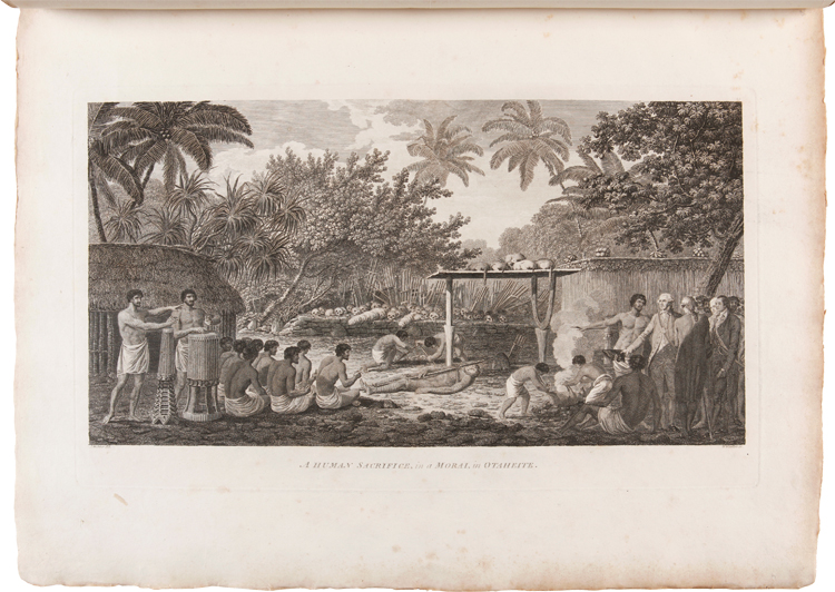
Description: 24 x 35 cm handcoloured print. Cropped, but not affecting the image. This engraving is after a drawing by John Webber from John Hawkesworth's account (1773) of the voyages of Captain James Cook, Joseph Banks and Captain John Byron. John Webber was the artist on Cooks third voyage from 1776-1780. Cook traveled to Nootka Sound, Vancouver Island, between March 29 and April 26, 1778. Illustration shows the local method of cooking, the rows of smoked salmon under the ceiling, the opening of the roof for the entry of light, the inhabitants seated on mats, their occupation at weaving, etc.
Seller: Attic Books (ABAC, ILAB), London, ON, Canada

Price: US$125.00 + shipping
Condition: Good
Description: Engraving on laid paper. Marginal defects and time stained. 9.75 x 15 inches.From A New, Authentic, and Complete Collection ofVoyages Round the World,Undertaken and Performed by Royal Authority.Containing an Authentic, Entertaining, Full, and Complete History ofCaptain Cook's First, Second, Third and Last Voyages,Undertaken by Order of his Present Majesty, for making Discoveries in Geography, Navigation, Astronomy, &c.Publishing under the immediate direction ofGEORGE WILLIAM ANDERSON, Esq ;Assisted by the Principal Officer who failed in the Resolution Sloop,And by many other Gentlemen of the most distinguished Naval Abilities
Seller: Wittenborn Art Books, San Francisco, CA, U.S.A.

Price: US$195.00 + shipping
Condition: Very Good
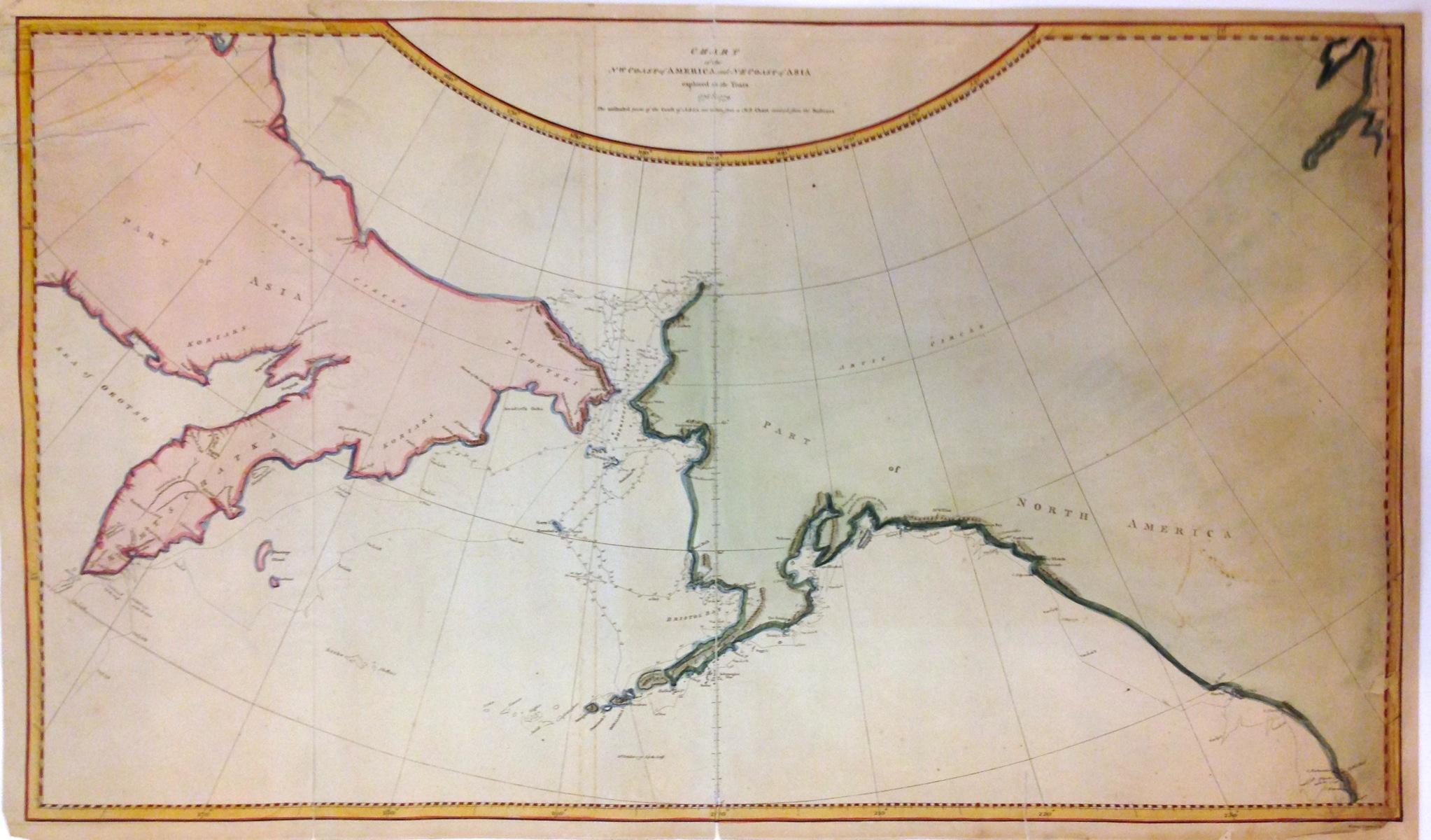
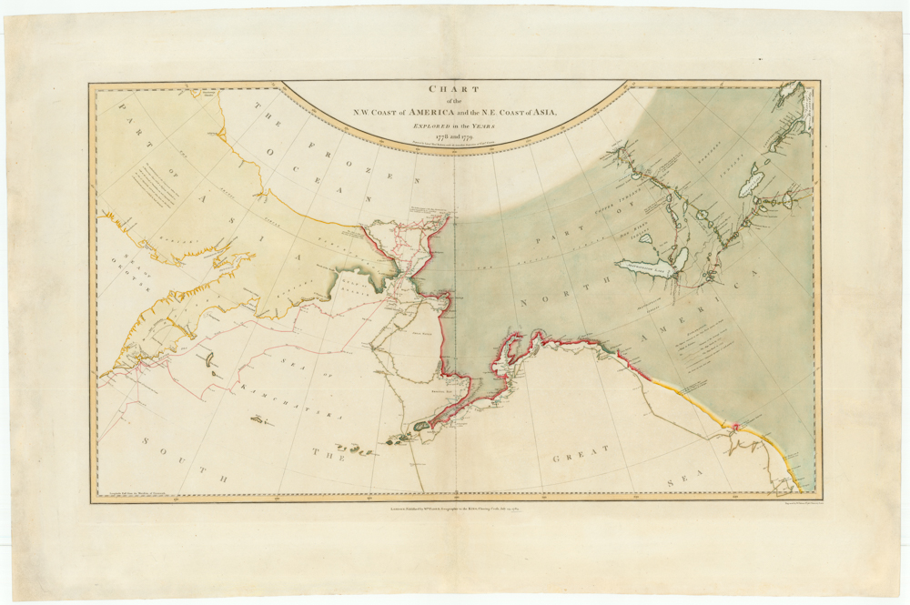
Description: MAP DESCRIPTION: Original 1784 map (Plate XVIII) disband from the Dublin, 1784 edition of Cook's Voyage to the Pacific. The map shows NE coast of Asia, Bering's Strait, and NW part of North America, including Norton Sound. Shows Cook's sailing tract with dates. Sheet measures 10.75" (h) x 15.5" (w). Map is laid flat on archival foam core and shrink wrapped. MAP CONDITION: Very Good overall, minor 1/2" tear to edge, else complete and slightly soiled. CONTENTS DESCRIPTION: Good details on the map showing land features and topography with dates of exploration around the coasts beginning on Jan 18 1778 and departing on Aug 1778 and again July 1779. Very nice old, original 1784 map of the North Pacific; ready for framing.
Seller: NorthStar Books, Spokane, WA, U.S.A.

Price: US$200.00 + shipping
Description: According to the OCLC this is "Map showing the Leeward Islands situated in the western portion of the Society Islands, located northwest of Tahiti and features Maurua [i.e. Maupiti], Tubai [i.e. Tupei], Bolabola [i.e. Bora Bora], Ulietea [i.e. Raiatea], and Huaheine based on James Cook's surveys of his first voyage of the Pacific in July 1769. Imprint on map: London : Published by Alexr. Hogg at the Kings Arms, no. 16 Paternoster Row. Map opposite p. 515 from: A new, authentic, and complete collection of voyages round the world : undertaken and performed by royal authority : containing a new, authentic, entertaining, instructive, full, and complete historical account of Captain Cook's first, second, third, and last voyages, undertaken by order of His present Majesty, for making new discoveries in geography, navigation, astronomy, &c. in the Southern and Northern Hemispheres, &c., &c., &c. : to which will be added, complete and genuine narratives of other voyages of discovery round the world, &c. / . under the direction of G.W. Anderson. London : Alexr. Hogg, [1784-86]." Two bits of light foxing otherwise quite nice condition.
Seller: Recycled, Corte Madera, CA, U.S.A.

Price: US$600.00 + shipping
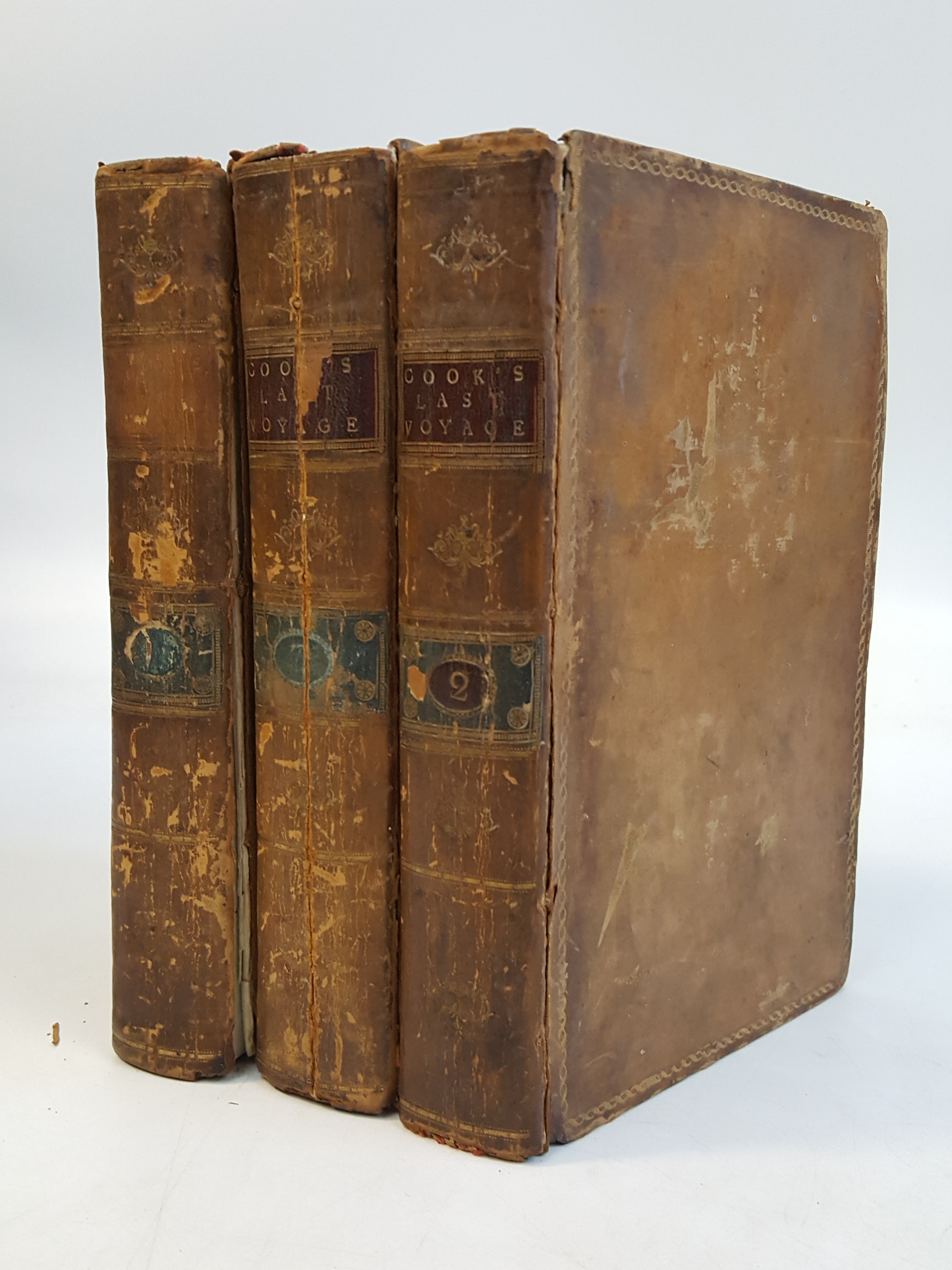
Description: 3 volume set, full calf, octavo, large folding map, 23 folding plates, front cover of Volume II is deteched, tight bindings on the other two, , no marks to the text, foxing, soiled page edges, 1" split to hinge of Vol. III, boards are worn at the edges and corners, nice finish to the covers, mildly stained and worn, bookplates. Volumes I and II are Good, Volume III is Poor
Seller: COLLINS BOOKS, Seattle, WA, U.S.A.
Price: US$650.00 + shipping
Condition: Very Good
Description: First Dublin edition of the official account of Cook's third voyage. These, the first 2 Volumes (of 4 published) , were the only ones written by Cook. Volume 3 was written by James King and Volume 4 (when present) comprises the Map Volume. Vol 1 is 421 pages (plus preliminaries) ; Vol 2 is 549 pages. Page 471 in Vol 2 mis numbered as '741'. These two volumes lack the plates and maps. Some copies of this edition were issued this way. A very clean and solid set, bound in what appears to be the Original 18th Century leather (Calf ? ? ). Gilt spine decorations and lettering. Binding is quite solid and remarkably unworn, given the age. A solid, attractive set of a Rarity of World Exploration. ; 8vo 8" - 9" tall;
Seller: Gerry Kleier Rare Books, Martinez, CA, U.S.A.
Price: US$837.37 + shipping
Description: , in 3 volumes (To Determine the Position and Extent of the West Side of North America, its Distance from Asia and the Practicability of a Northern Passage to Europe, Performed Under the Direction of Captains Cooke Clerke and Gore, in His Majesty's Ships the Resolution and Discovery, in the Years 1776 1777 1778 1779 and 1780), 2 plates with titles (Vol I engraved frontispiece portrait, folding Table of Numerals), armorial bookplate to each volume New Edition , some wear to all volumes, bumping to corners, splits to joints and boards loosely held in places, chipping to spine edges, vertical split to spine of Vol III, very slight splitting to hinges, small section missing upper free endpaper Vol I, marking to endpapers, interiors in good condition, exteriors in fair condition , full calf, gilt decorative border to boards, gilt decoration and rules with titles on labels to spines, blindstamped decorative turn-ins, green edges, octavo, 22 x 13.5 cms Hardback ISBN:
Seller: Keoghs Books, Skipton, United Kingdom
Price: US$875.00 + shipping
Description: Map. Engraving with modern hand coloring. Image measures 16" x 27.25". This important and scarce 1784 map of the North Pacific covers the northwest coast of America including Alaska east as far as the Hudson Bay and the northeast coast of Asia including Kamchatka. The map is from the first edition of the official account of Captain James Cook's Third Voyage in the HMS Revolution between 1778 and 1779. The route of his journey is depicted in detail with depth soundings noted along the route. Several Capes, islands and bays are labeled. This map is among the first to accurately map the coastlines of the region.It was during this voyage, that Cook encountered an 'impenetrable wall of ice' in the Arctic as he searched for the Northwest Passage, thus putting to rest the hopes for the discovery of an Arctic Northwest Passage. Map was engraved by T. Harmer for the official account of Cook's voyages. The map is in fair condition. Right margin is extended and filled in. Minor loss near bottom margin, not affecting printed area. Shows wear along original fold lines. Minor foxing. Verso repair near top left. Lined with archival paper.Captain Cook (1728 -1779) was among the most famous and important explorer, navigator, cartographer and captain of his time, whose scientific and geographical knowledge influenced his successors well into the 20th century. He started sailing as a teenager and went on to join the Royal Navy in 1755. In 1766, he was commissioned to explore the Pacific and went on the sail thousands of miles across largely uncharted regions of the world. These three historic voyages led him to some of the first sightings of Antarctica, his discovery of many Polynesian islands, including the Hawaiian Islands, first European contact with east Australia, the circumnavigation of New Zealand and the first correct mapping of the Pacific Northwest.
Seller: Argosy Book Store, ABAA, ILAB, New York, NY, U.S.A.
Price: US$1200.00 + shipping
Condition: Very Good
Description: First Irish Dublin Edition. With provenance. 3 Volumes. Full calf with five raised bands on spine. Volume 1: titles worn from spine, worn , front cover starting, back cover detached but present. Lovely engraved copper plate frontispiece portrait of Captain Cook, reinforced from behind. Volumes 2 & 3: wear to boards. Signed twice and previously owned by Reverend Doctor Hugh Knox (1733-1790), mentor to Alexander Hamilton. Signed multiple times by Hugh Knox. Knox was famously the man who mentored Hamilton on St. Croix, urged him to go to America, and reached out to friends there on Alexander Hamilton's behalf. Extremely scarce provenance. Additional shipping required for this set.
Seller: J. Mercurio Books, Maps, & Prints IOBA, Garrison, NY, U.S.A.

Price: US$1200.00 + shipping
Description: First Dublin edition. With engraved portrait frontispiece and folding appendix table. [8], xcviii, 421; [14], 549; [12], 559 pp. 3 vols. 8vo. First Dublin edition of the official account of Cook's final voyage, the issue without plates and maps. Beddie 1546; Forbes 72; Howes C-729a; Sabin 16250 Near contemporary straight grained black morocco over marbled boards. Some shelfwear to boards, internally clean With engraved portrait frontispiece and folding appendix table. [8], xcviii, 421; [14], 549; [12], 559 pp. 3 vols. 8vo
Seller: James Cummins Bookseller, ABAA, New York, NY, U.S.A.

Price: US$2000.00 + shipping
Description: First Irish Edition. Hardcover. First Dublin edition of the official account of Cook's third voyage. This edition occurs with maps and plates included in the three volumes; with the maps and plates in a separate atlas volume (in 4 vs) and without any plates & maps. This set is of later iteration, having only the frontispiece and fold-out chart (in Appendix). (Beddie 1546. Sabin 16250. Howes C-729a.) Noted flaws notwithstanding, a very presentiable set of this classic work. Light shelf/edge wear, ownership markes at ffep(s), touch of toning/foxing at preliminaries, spines slightly darkened and dried (likely exposed to a fire at some point, else tight, bright and unmarred. Full brown period boards, red and black leather spine labels, gilt lettering, frontispiece, fold-out chart. 8vo. 421pp; 549pp; 559pp. Appendix.
Seller: Lux Mentis, Booksellers, ABAA/ILAB, Portland, ME, U.S.A.

Price: US$2351.30 + shipping
Condition: Very Good
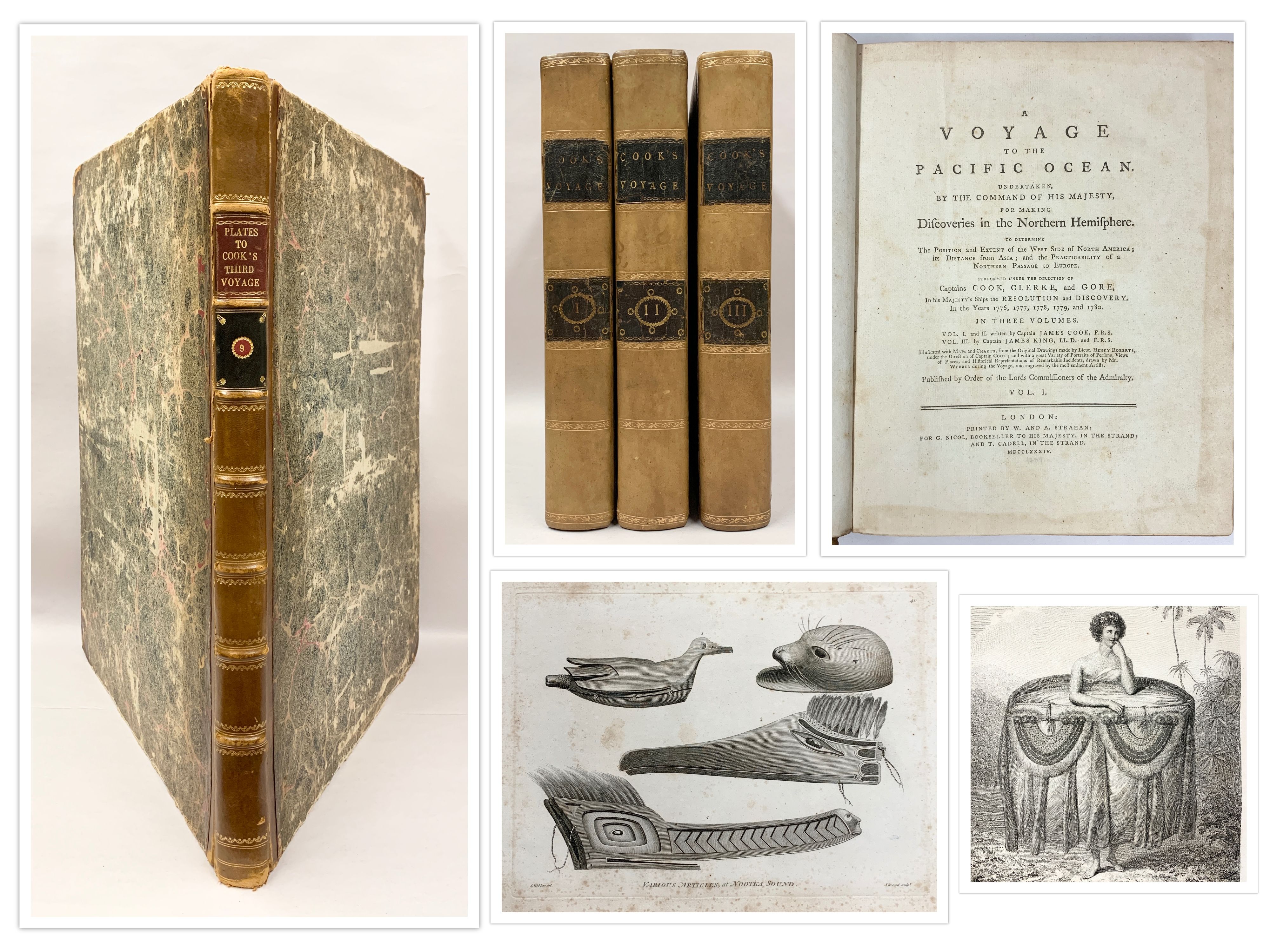
Description: London, W. and A. Strahan, 1784 [first edition]. Quarto, three volumes, collating complete with the 18 engraved maps (9 folding), 6 folding engraved plates of views, a folding table and an advertising leaf at the rear of the third volume. Contemporary full tree calf, spine gilt-decorated with contrasting title-labels; leather on the hinges and some corners renewed at an early stage, with some wear now to the extremities; inner hinges reinforced; a few old (ink?) splashes to the leading edges; endpapers and adjacent leaves a little discoloured around the edges by the leather turn-ins; charts and adjacent leaves a little foxed or offset, with occasional foxing to a few isolated sections; small blank bottom corner pieces missing from two leaves; trifling signs of use and age; a very good set. The large folio atlas is not present with this set of the official account of Cook's third and final voyage. The first two volumes were written by James Cook, the third volume by James King. With the armorial bookplate of John Dixon in each volume. [3 items].
Seller: Michael Treloar Booksellers ANZAAB/ILAB, Adelaide, SA, Australia
Price: US$2687.20 + shipping
Description: Containing a New Authentic, Entertaining, Instructive Full and Complete Historical Account of Captain Cook's First, Second, Third and Last Voyages, Undertaken by Order of his Present Majesty, . and Successively Performed In the Years 1768, 1769, 1770, 1771-1772, 1773, 1774, 1775-1776, 1777, 1778, 1779, 1780. .London: Alex Hogg, (1784- 1786). Thick folio. Bound in full calf with contrasting blind panels on both covers. Spine with raised bands preserving the original title-label. (656pp.). With portr. of Capt. Cook, plus additional frontispiece, large fold. map, and 151 full-page engraved plates of which 25 are full-page maps. List of subscribers not included. Date below portrait, Sept. 11, 1784. Printed in double-column. A nice copy.
Seller: Berkelouw Rare Books, Berrima, NSW, Australia

Price: US$2750.00 + shipping
Condition: Very Good
Description: Framed chart. Area of exposed chart, shown within mat, measures 37.5" x 24". Provenance: Sold by a Hawaiian print seller, 1980s, with their stamp on frame verso. Framed in an sophisticated wood frame with walnut inlay, matted on archival stock and off-white linen border behind UV-ray protection plexiglass. Condition: Folds extant from original position in the folio atlas of Cook's Third Voyage. Two pinholes, one below the southern tip of Africa; one below the southwest tip of Australia, or New Holland. A small tear, one-eighth inch, in the Gobi desert. See the last three photos for details of the three holes. Frame has slight abrasion to exterior side lower right molding -- please see second photo. For the third and fourth photos, please excuse elements of glare. They are not defects in the chart. An uncommon chart in attractive condition and well-framed. When published, the chart revealed the most complete knowledge of world cartography extant.Captain James Cook's supreme achievement, in which during three voyages details of the Pacific Ocean became known to the world when published, posthumously, after the third voyage returned to England. The magnitude of Cook's discoveries are charted here, laying the groundwork for future non-native settlement in Australia, New Zealand, Hawaii, the Northwest Coast, etc. Indeed, his discovery of otter pelts, loaded at Nootka Sound and traded in Canton, can be viewed as the harbinger of trade between North America and China.Reveals the routes of Cook's three voyages, starting with the Endeavour (1768-71), followed by the two voyages of the Resolution (1772-75 and 1776-80) with notes along the tracks ("Seagull Seen Here"). The West Coast of America is nearly barren, revealing only Monterey (location of Spanish mission) and Nootka Sound, where Cook noted in his journal that Chief Maquinna was wearing as a necklace a spoon of Spanish origin. Roberts began this chart under Cook's behest; after Cook's death in the Sandwich Islands, the Admiralty ensured Cook's work would be encompassed and memorialized with this chart. It was used in the official account of the third voyage, 1784.In the Bibliography of Captain James Cook R.N., F.R.S., Circumnavigator, edited by M. K. Beddie and published by The Library of New South Wales (Second Edition, 1970), the plate is listed on page 330 as published in "A Voyage to the Pacific Ocean . for making discoveries in the Northern Hemisphere." In Wagner, "The Cartography of the Northwest Coast of America to 1800" (U of CA Press, 1937), the chart is listed as item 699, "drawn by Lieutenant Henry Roberts and engraved by William Palmer."
Seller: Long Brothers Fine & Rare Books, ABAA, Seattle, WA, U.S.A.

Price: US$2867.99 + shipping
Description: A Voyage to the Pacific Ocean undertaken by the Command of His Majesty for making Discoveries in the Northern Hemisphere in the years 1776, 1777, 1778, 1779, and 1780. Volumes I and II written by Captain James Cook, Volume III written by James King. Volume I is the 1st edition published by W A Strahan for G Nicol and T Cadell in 1784, Volume II and III are the 2nd edition published by H Hughs for G Nicol and T Cadell in 1785. The true 1st of Volume I is exceptionally rare. Does not include atlas sold separately mentioned in total list of plates in volume I.Volume I - 421 pages with 8 plates of varying sizes including full foldout engravingsVolume II - 548 pages with 11 plates including foldout engravingsVolume III - 556 pages including appendix with 6 plates including foldout engravingsClean pages, solid binding with volume I having hinge repair, boards show rub wear and light bumping Clean pages, solid binding with
Seller: HGG Books, Slingerlands, NY, U.S.A.
Price: US$3786.67 + shipping
Condition: Very Good
Description: VERY RARE - SCARCE EDITION, FINE ORIGINAL LEATHER BINDINGS, RARE FIRST EDITION. THREE VOLUMES, 26 FINE ENGRAVED MAPS, CHARTS and FRONTISPIECE of Captain James Cook, A VOYAGE TO THE PACIFIC OCEAN Undertaken by the command of His Majesty, for making Discoveries in the Northern Hemisphere. To determine The Position and Extent of the West Side of North America; its Distance from Asia; and the Practicability of a Northern Passage to Europe. Performed under the direction of Captains Cook, Clerke, and Gore In His Majesty's Ships the Resolution and Discovery. In the Years 1776, 1777, 1778, 1779, and 1780. In Three Volumes. Volumes I and II written by Captain JAMES COOK, Volume III by Captain JAMES KING, Illustrated with Maps and Charts, from the Original Drawings made by Lieut. Henry Roberts, under the Direction of Captain. Published by Order of the Lords Commissioners of the Admiralty. DUBLIN: Printed for H. Chamberlaine, W. Watson, Potts, Williams, Cross, Jackson, Moncrieffe, Walker, Jenkin, Burnet, Wilson, Wogan, Exshaw, Vallance, Beatty, White, Whitestone, Burton, Byrne, Mills, J. Porter, Stewart, Wallace, Higly, Cash, Herey and Mc.Kenzie. MDCCLXXXIV. 1784. RARE FIRST EDITION. The First DublinEdition. In 3 volumes. 8vo. 8.5" x 5.5" Inches (LxB). Pp. [viii], xcvi, 421; [xiv], 549; [xii], 559 pages, with 24 (of 26) numbered (SEE BELOW), engraved maps, coastal profiles and charts, many folding (are paginated for the three volumes) + the rare frontispiece portrait is present (usually found missing), + folding table of numbers expressed in various languages of the Malay region; 6 other appendices; at the end of volume 3. This edition was issued with maps and plates included in the three volumes. [Holmes 47; Mitchell Library 1543; Sabin 16250]. In the original contemporary full calf leather bindings with two red & dark green gilt lettered morocco labels added. The First Dublin Edition of the official account of Cook's third voyage : intended to seek the Northwest Passage and to return Omai to Tahiti. Officers of the crew included William Bligh, James Burney, James Colnett, and George Vancouver. The voyage resulted in what Cook judged his most valuable discovery - the Hawaiian islands. The first London edition sold out in three days. Scarce set in 3 volumes. A classic work. A rare book set in the original contemporary full calf leather bindings, some wear/tear/scuffing/chipping to covers, spine, ends & corners, pages - plates with minor age toning are clean & bright. Hinges split & visible from the outside, all the boards are still firmly attached & the bindings are tight & intact., volume 1 spine has a split which has been professionally repaired. NOTE: Missing from VOL. I is the list of plates which should have been on page XCVII. The following collation of plates: In the first volume page xcvii (List of Plates) is missing. It's difficult to speculate why since it appears that most if not ALL the plates are present. I also believe that there are three plates (Two of them large maps that are not numbered) but are still part of the 26 total plates in the volumes. I also believe that the frontispiece portrait of COOK is considered to be one of the 26 plates since all plates including the frontispiece are used in the collation of plates. Here is a listing of what I have found along with my opinion: (VOLUME 1) 1. Frontispiece: Captain James Cook (I believe this to be plate I) 2. Plate IV is a fold out map on page 50. It should actually be attached to page 83 along with another plate also labeled as number IV. They should be plates III & IV respectively.3. Plate III on page 61 (Should probably have been listed as Plate 2) 4. Plate IV on page 83 5. Plate V on page 87 (Should be on page 91) 6. Plate VI on page 117. 7. Plate VII on page 225. 8. Plate VIII on page 277. PLEASE CONTACT SELLER FOR REST OF COLLATION
Seller: Barry's Books, San Antonio, TX, U.S.A.
Price: US$3900.00 + shipping
Condition: Very Good
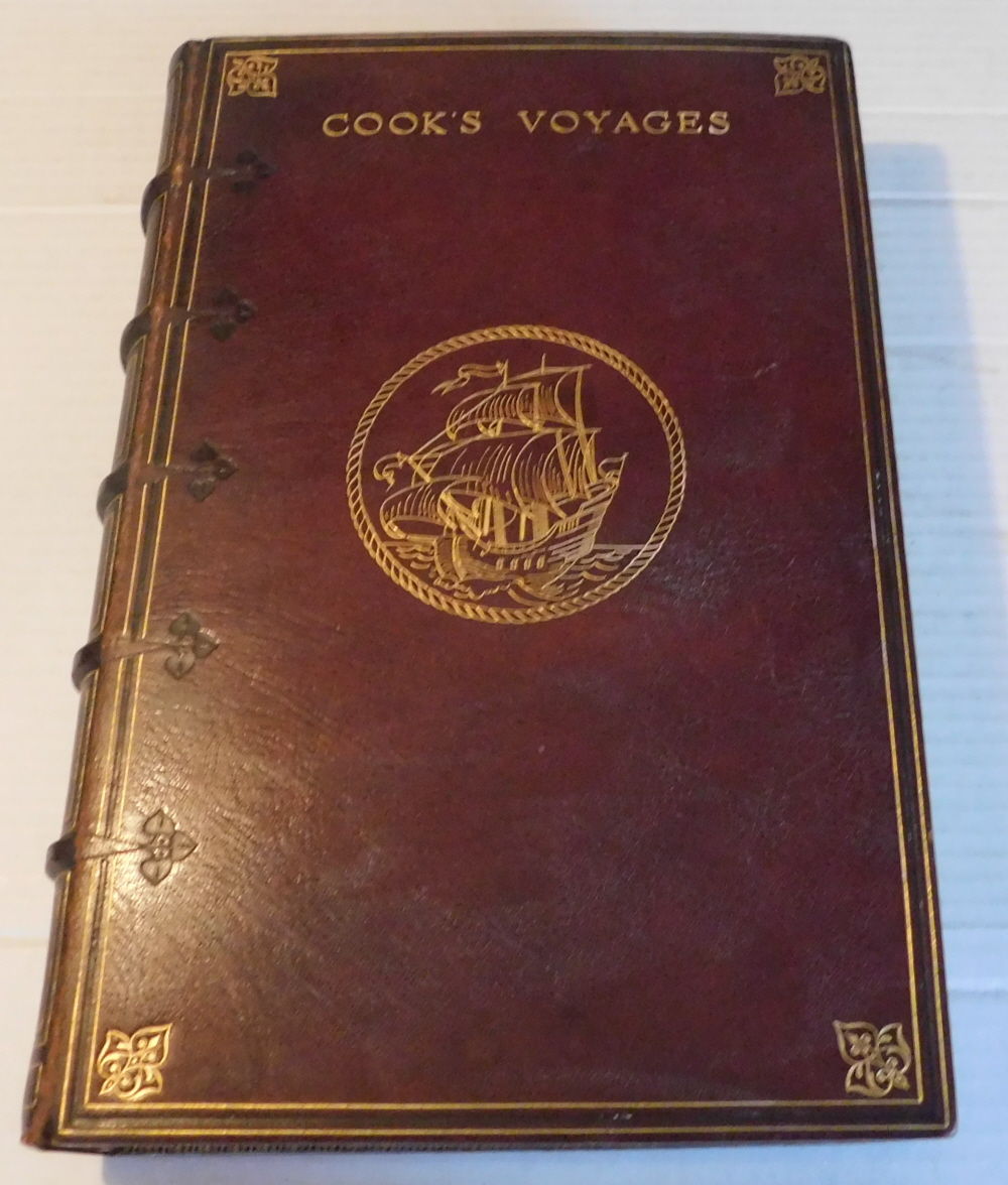
Description: London: printed for Alex. Hogg, at the KingÂs Arms, no. 16, Pater-Noster-Row; and sold by all booksellers and news-carriers, [1784-1786]., [1784-1786]. Very good. - Folio, 15-3/4 inches high by 9-3/4 inches wide. Bound in full dark red morocco by Sangorski & Sutcliffe, with rough gilt edges, a three line panel in blind and gold, with gold corner ornaments and blind trefoils. Titled "Cook's Voyages" in gilt on the front cover and between raised bands on the spine. In the center of the front cover is a sailing vessel of the period in full sail, tooled in gold outline, surrounded with a gold tooled circle representing rope. There is a small tear to the head of the spine and the joints and bottom edges of the covers are lightly rubbed. Pages iv, 5-655 + v, with a frontispiece portrait of Cook with a tissue guard, engraved, as follows, at the foot of the plate: "Accurately drawn from an original painting & engraved by Mr. Thornton". Illustrated with 156 plates and charts including the frontispiece and a 12-1/2 inch high by 19 inch wide folding map engraved by Thomas Conder based on notes by Cook and Lieut. Roberts, "A New General Chart of the World, Exhibiting the Discoveries made by Captn. James Cook in his First, Second and Third Voyages : With tracks of the Ships under his Command". Due to the tightness of the binding some of the captions at the bottoms of the plates are difficult to read. The book is lacking a plate, "The Landing of Captain Cook at Middleburgh", which appears never to have been bound in. The book includes "Directions to the Bookbinder' [1 page] and "A List of Subscribers to this Work" [4 pages]. Stamped in gilt at the top of the front pastedown is the statement "Bound in England" and at the foot of the front pastedown "Bound for J.W. Robinson Company by Sangorski & Sutcliffe, London". The label of the J.W. Robinson Company, Los Angeles, is mounted on the rear blank. The contents are bright & clean with minor flaws only. A beautiful example of this classic book. The titles for Cook's voyages are as follows: p. [5] "A New, Genuine and Complete History of the Whole of Capt. Cook's Voyages, Undertaken and Performed by Royal Authority". p. [108] "Capt. Cook's Second Voyage Towards the South Pole and Round the World". p. [399] "A New, Authentic and Complete History of Captain Cook's Third and Last Voyage to the Pacific Ocean"."This compilation of British navigators' accounts of their voyages around the world covers the famous voyages of Sir Francis Drake and Captain James Cook, as well as expeditions by George Anson, John Byron, Samuel Wallis and Philip Carteret, and Constantine Phipps (Lord Mulgrave). In 1740-44, Anson led a three-year-and-nine-month mission that raided Spanish commerce off the coast of Peru before returning to England via the Cape of Good Hope. Byron made a voyage in 1764-65, during which he discovered the Islands of Disappointment (in present-day French Polynesia) and several smaller islands. Wallis and Carteret set out in 1766 to find a rumored, but non-existent, southern continent at 20 degrees south latitude. Failing to find such a landmass, they went on to discover Tahiti and a number of other islands in what is now French Polynesia, before returning to England in 1769. Mulgrave was the first British Arctic explorer. In a 1773 attempt to find a passage to Asia via what some navigators speculated was an "Open Polar Sea," he made the first scientific voyage aimed at reaching the North Pole. Sailing north from England, Mulgrave and his two ships reached the west coast of Svalbard, Norway, before being forced to turn back by pack ice."- quoted from a description provided by the Library of Congress.
Seller: Blue Mountain Books & Manuscripts, Ltd., Cadyville, NY, U.S.A.
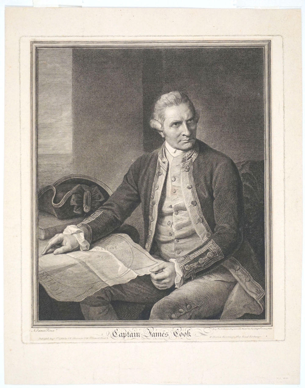
Dance, Nathaniel. Captain James Cook. J. K. Sherwin, London, 1784.
Price: US$4400.00 + shipping
Description: A fine copy of the second issue of Cook's famous portrait after Nathaniel Dance, beautifully engraved by J. K. Sherwin. This impression was published in London 1st August 1784, (the 1st was published April 20th 1779). This portrait was issued in 1784, at a time when portraits of Cook were in tremendous demand. Crisp dark three-quarter image of Cook seated with a map of the Southern Ocean on his knee, resting against the table, with "New Holland" barely legible on the map. This famous portrait of Cook was painted by Dance in May 1776, prior to Cook's departure on his 3rd & final voyage. The artist was one of the leading portrait painters of the day. It was said by David Samwell (1751-98) fellow voyager with Cook and ship's surgeon on the Discovery, that "It . is a most excellent Likeness to Capt. Cook; and more to be valued, as it is the only one I have seen that bears any resemblance to him." Most of the busts and statues that were executed after Cook's death were, apparently, founded on Dance's Portrait. An important image. Engraved by J.K. Sherwin, No. 28, St. James's Street & and W. Hinton Sweetings Alley Royal Exchange. Beddie 3384; see Nan Kivell p.73 #9 for 1st impression. Image size measured within ruled frame lines 9 1/4 x 11 5/8"; impression mark 10 1/8 x 11 3/4", with a minimum of 3/4" borders outside the plate mark.
Seller: Antipodean Books, Maps & Prints, ABAA, Garrison, NY, U.S.A.
Price: US$5273.63 + shipping
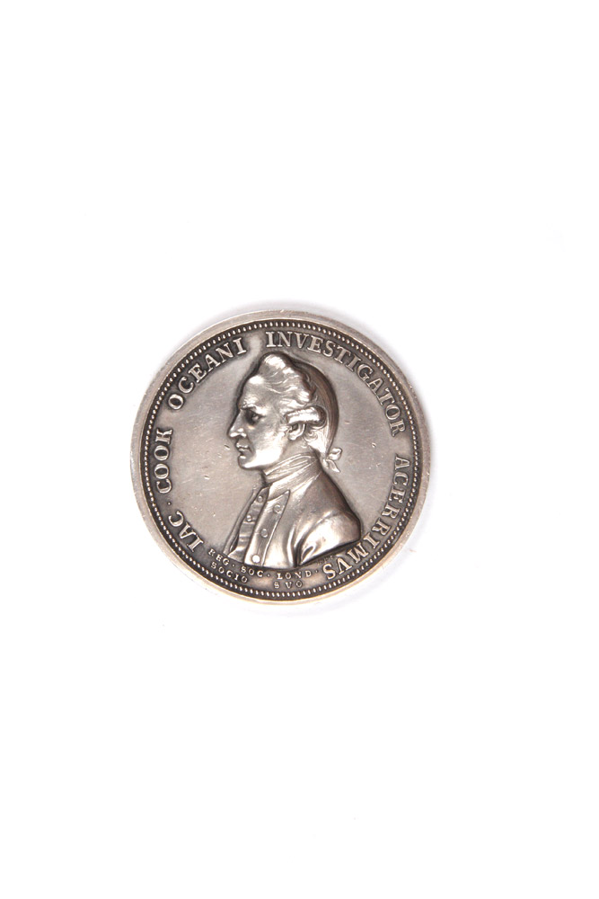
Description: Silver medal, 43 mm. diameter; relief bust of Captain Cook on recto, full-length relief portrait of Fortune leaning on a column while resting her hand upon a rudder and globe on verso. The handsome silver issue of the Royal Society's formal memorial to the great navigator. Fellows of the Royal Society were entitled to a free bronze medal, while silver and gold issues were available by subscription only; some were reserved for presentation. L. Richard Smith (in The Royal Society Cook Medal, Sydney, 1982) has suggested a probable final minting figure of 22 gold, 322 silver and 577 bronze medals. An engraving of the medal was printed on the title-page of the second and third editions (and some copies of the first) of the official account. The commissioning of this medal was due above all else to the efforts of Sir Joseph Banks, who supervised 'the minting and distribution of the Royal Society Cook medal as a personal task coincident with the publication of the narrative of the tragic third voyage' (H.B. Carter, Sir Joseph Banks, 1988, p. 168). Cook's European reputation is borne out by several letters to Banks from the Continent requesting specimens of the medal, including one from Bougainville, who wrote in June 1785 to remind Banks that as a member since 1756 he felt entitled to one (see The Banks Letters, ed. W.R. Dawson, 1958, p. 122). .
Seller: Hordern House Rare Books, Surry Hills, NSW, Australia
Price: US$6441.31 + shipping
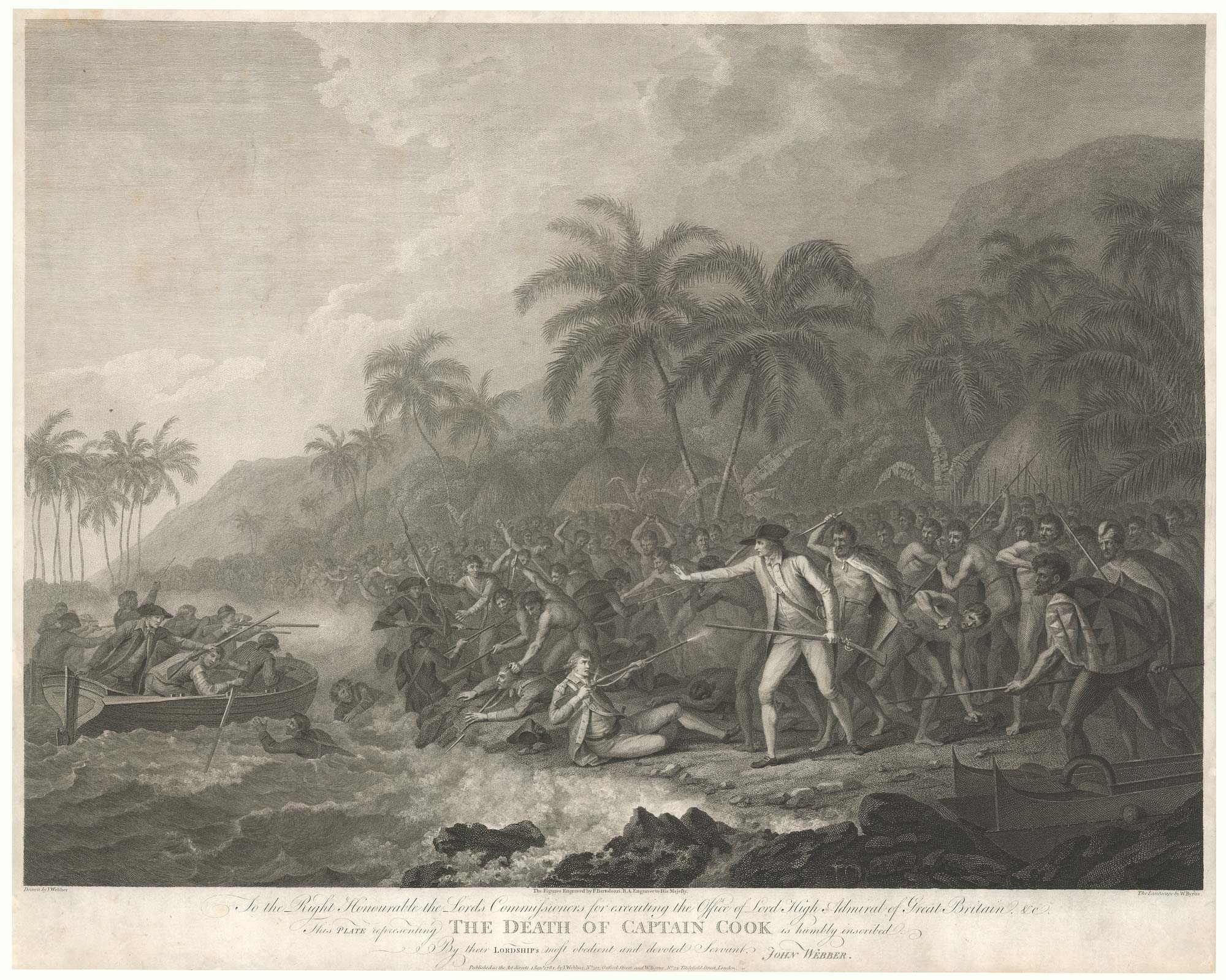
Description: London: John Webber & William Byrne, 1784. Engraving with etching. Sheet 470 x 595mm. Trimmed to plate as usual, a few minor repairs to edges. A rare example of this famous scene of the death of Captain James Cook on Hawaii, showing the explorer attempting to restrain his crew, unaware of the dagger about to be plunged into his back. It was published separately about six months before the Official Account of the voyage, which contained many illustrations by John Webber (1751-93) but, strangely, not a 'death'. In the years after his return to England Webber exhibited a number of oils from the voyage at the Royal Academy and, with this print, he attempted to capitalise on his work with a better-quality engraving for the connoisseur market. He and the engraver William Byrne (1743-1805), who also worked on the Official Account, co-financed the publication and employed famed Italian engraver Francesco Bartolozzi (1727- 1815) to add his flair to the figures. Although it is unlikely that Webber was an eye-witness, his version of the events was influential, creating the image of Cook as victim rather than aggressor.
Seller: Altea Antique Maps, London, United Kingdom
Price: US$9500.00 + shipping
Condition: Good
Description: 4 volumes -- 3 quartos, and 1 atlas folio. [8], xcvi, 421; [11], 549; [12], 558, [1]; 59 pages. Illustrated altogether with 85 plates and maps of which 24 are in the text and 59 in the atlas. Original leather bindings, beautifully rebacked in brown calf with black leather spine labels. London: W. and A. Strahan, 1784. A very good copy. The atlas volume has some foxing and dampstains in the upper margin, the interior is generally clean. First edition of the official account of Cook's last voyage. "This third voyage differed from the other two in that the scene of discovery shifted from the South Seas to the North Pacific and the west coast of North America, and had as one of the objectives the attempt at a Northwest Passage to Europe. On the way north the voyagers touched (discovered) the Sandwich Islands, so named after Lord Sandwich but later called the Hawaiian Islands, where Cook met his death on his return from the North". -- Cox I, 63.
Seller: Argosy Book Store, ABAA, ILAB, New York, NY, U.S.A.
Price: US$9500.00 + shipping
Condition: Very Good
Description: The Legendary lost chart of Captain Cook Rare first edition. This map of Captain James Cook s third and final voyage (1778 1780) was published in London in 1784 and accompanied by many sketches and drawings by his officers. A second edition was published in 1794. On this final voyage, Cook and his men became the first Europeans to visit the Hawaiian Islands, which they named The Sandwich Islands. The expedition then sailed up the northwest coast of North America, up into the Bering straits and the Arctic Ocean, in search of the Northwest passage, before sailing south, returning to Hawaii in 1779. They stayed in Hawaii for a month. Then just as they were to leave, a skirmish took place between the Hawaiians and Cook s men. During this skirmish, Cook was killed. On that journey north, Cook made the first complete charts of the Northwest of America, including Spanish and Russian possessions, he also charted the north Alaskan coast, and northern Siberian coast in the Chukchi Sea or perhaps more properly, these charts were made by Lt. Henry Roberts, the master s mate, under the immediate supervision of Capt. Cook. After Cook s death, the expedition again sailed north under the command of Captain Charles Clerke to the Bering straits, and then south, along the coast of Siberia, charting the journey down the coast of the Kamchatka Peninsula. Following the expedition s return to England in 1780, the much-anticipated journals and charts of the journey fell prey to Cook s political enemies (and perhaps to the political influence of the Hudson Bay Company), with the result that Roberts s chart was not included in the official publications of the journey, but rather was published separately. Because of this history, it has become known as The Legendary Lost Chart of Captain Cook. The chart that Roberts sold to publisher William Faden included Samuel Hearne s c.1772 manuscript map of the Coppermine River in Canada, then in the possession of the Hudson s Bay Company, and which had never before appeared in print. Hearne s exploration of the Coppermine, whose waters eventually run all the way to the Arctic Ocean, proved that there was no Northwest Passage through Hudson s Bay. It is possible that the Hudson s Bay Company wished to suppress this information, thus contributing to the less detailed map that was included in the official publication. Hearne s journal and maps weren t published until full decade after our Roberts/Faden map. Another possible reason that Roberts chart was dismissed from the official account could be a result of the involvement of Alexander Dalrymple in the selection process. Dalrymple may have harbored ill feelings towards Cook for having been chosen, instead of him, to lead the Second Pacific Voyage of 1772-75, an expedition that ultimately disproved the myth of Terra Australis Icognita ( the unknown southern land ) the vast hypothetical landmass based on classical beliefs in symmetry that appeared on maps between the 15th and 18th centuries an idea which of Dalrymple himself advocated. As such, Dalrymple may have wanted to downplay Cook s achievements and discoveries. For two hundred years, the true source of the Faden publication was unknown, until, in 1985, the British Library acquired a proof copy that served to prove its source. Because it was not the official publication, this striking map is much rarer than the official map, while at the same time it contains more information (in addition to the Hearne journey, it contains many place names not included in the official map).
Seller: Neatline Antique Maps, Tiburon, CA, U.S.A.
Price: US$10000.00 + shipping
Description: 4to. Complete four volume set of the first edition. In the original boards, but boards detached. Overall, the contents remain tightly-bound and in remarkably good condition. Vol. I complete but for The List of Plates (pp. xci to xcvi - however, included in the fourth volume - see below), and all seven maps on six plates (four folding), and one folding plate, are present. Vol. II complete with all eleven maps or views (six folding). Vol. III shows an early worm hole to the first few pages, not affecting text. All six maps and plates are present (two folding), plus the folding table at the end, but with no advertising leaf included. Vol IV contains 61 engravings of people, places, and animals visited by Capt. Cook in what is now Hawaii (described as the Sandwich Islands), Western British Columbia, and Alaska. Forty of the plates are folding; 21 are large single-page plates. The volume begins with 'The List of Plates', and is numbered pages xci to xcvi (see above). Some of the illustrations are foxed. This volume lacks three charts (nos. I and VI from vol. I, and no. XXXVI from vol. II). There is foxing (off-setting, really) on the pages facing the plates and charts, and occasional marginal foxing to the text, but the latter is hardly untoward. Beddie, Bibliography of Captain James Cook (BCJC) 1543, Streeter 3478. Sabin 16250, Howes 729a, Sotheby's London sale 11/21/91 lot #377 (three vols only).
Seller: BISON BOOKS - ABAC/ILAB, Winnipeg, MB, Canada
Price: US$11000.00 + shipping
Description: Sixty-one plates and two charts (one folding, one double-page), most with original tissue guards. Large folio. 20th-century three-quarter mottled calf and marbled boards, spine richly gilt, red and green morocco labels. Light scattered foxing and soiling, rarely touching plates. "General Chart" with two neatly repaired tears near the edges. A handsome, untrimmed copy. A complete, untrimmed copy of the atlas volume that accompanied the official first publication of Cook's third and final voyage. This atlas is very notable for its outstanding views of the peoples and scenery of the Hawaiian and Pacific islands and the far Northwest. "Cook's third voyage was organized to seek the Northwest Passage and to return [the islander] Omai to Tahiti. Officers of the crew included William Bligh, James Burney, James Colnett, and George Vancouver. John Webber was appointed artist to the expedition. After calling at Kerguelen Island, Tasmania, New Zealand, and the Cook, Tonga, and Society Islands, the expedition sailed north and discovered Christmas Island and the Hawaiian Islands, which Cook named the Sandwich Islands. Cook charted the American west coast from Northern California through the Bering Strait as far north as latitude 70 degrees 44 minutes before he was stopped by pack ice. He returned to Hawaii for the winter and was killed in an unhappy skirmish with the natives. Charles Clarke took command and after he died six months later, the ships returned to England under John Gore. Despite hostilities with the United States and France, the scientific nature of this expedition caused the various governments to exempt these vessels from capture. The voyage resulted in what Cook judged his most valuable discovery - the Hawaiian Islands" - Hill. The large folio atlas which accompanied the first edition was printed at the expense of the public, and as such the entire set was sold "at the same price as it would be if without Plates excepting a small allowance for the cost of the paper & rolling press": in this case, three and a half pounds (Admiral Henry Dundas, as quoted in Forbes). The first edition was a roaring success, and is said to have sold out within three days. A lovely, untrimmed copy of the folio atlas to Cook's Third Voyage. FORBES 62.
Seller: William Reese Company - Americana, New Haven, CT, U.S.A.

Price: US$12428.31 + shipping
Description: Three volumes, quarto, and an atlas, folio, with altogether 87 engraved plates and maps, of which 63 appear in the atlas; contemporary diced russia leather, flat spines gilt in compartments with a complex design, black leather lettering pieces and round crimson numbering-pieces within dark green labels; the atlas volume in a neat modern binding of half calf and marbled boards. First edition of the official account of Cook's last voyage. This is a good set of this tremendous publication, the detailed narrative of the voyage extensively illustrated with beautiful engravings after John Webber, and so popular at the time that copies were sometimes literally read to pieces. "A magnificent summation of all the public and private journals, logs, drawings and other observations made during the voyage, and. as important a record of the exploration of the North Pacific as Cook's first two voyages had been for the South Pacific. It is in fact one of the most important English books published in the last quarter of the eighteenth century." (Forbes). The Resolution and Discovery made an enormous sweep throughout the Pacific, calling at Tasmania, New Zealand, the Cook Islands, Tonga and Tahiti before heading north and making famous landfall at the Hawaiian islands, which Cook named the Sandwich Islands in honour of his patron. After exploring the Northwest coast of America and returning to Hawaii, Cook was killed in the notorious skirmish ashore. Command passed to Clerke, and, after his death, to John Gore. The shocking news of the explorer's death reached England through overland reports from the Russian Pacific coast some months before the ships themselves returned. It marked the end of an age, and the beginning of another that would feature a number of the men who had been aboard the Cook voyage: among them Bligh, Vancouver, and Colnett. Unlike the official narratives of the first two Cook voyages, this was planned as a grander publication with the three text volumes containing some of the lesser illustrations but the 63 more important illustrations and maps appearing on a large scale in the separate folio-sized atlas volume. The result does justice to John Webber's superb visualisations of the Pacific. Webber was the official artist on the voyage: his romantic views remain the most evocative of all early portrayals of the islands, and helped to foster the notion of island paradise that so affected an European public eagerly reading the voyages of discovery being published in the eighteenth century. The full story of the voyage, including the narrative of Cook's murder at Kealakekua Bay, was so eagerly awaited by the public that the entire first edition sold out within three days, at the then huge price of four pounds fourteen shillings and sixpence, and copies were soon changing hands at up to ten guineas. . Provenance: Robert Baker (early signature in volume 1), possibly the Baker whose books were sold by Sotheby in 1855 and whose copy of the Cook second voyage atlas is in the Dixson Library, State Library of New South Wales; H. Mackenzie-Begg, with his small bookplate in each volume. Some scuffing to sides of text volumes, which have been skilfully rebacked with original spines laid down, lower panel of one spine repaired and a small defect in leather on another.
Seller: Hordern House Rare Books, Surry Hills, NSW, Australia
Price: US$15000.00 + shipping
Condition: Very Good
Description: 421p, 549p, 556p illustrated with 87 maps and views 63 of which are in the Atlas volume, all but a couple with tissue guards. 24 in the three quarto volumes. Bound in original leather boards, rebacked in the twentieth century in blonde calf not matching the original leather boards. Atlas volume folio with original marbled boards, and rebacked more recently and wearing along the base of the spine, splitting 6 inches down the front board, corners worn, yet still very attractive. Contents fine and with original tissue guards. Light foxing. Small bookplate in each volume, later personal gift inscription 1945 in each volume. This Atlas volume includes the rare plate "Death of Cook" not issued with the book but occurs in some copies
Seller: Old New York Book Shop, ABAA, Atlanta, GA, U.S.A.
Price: US$30000.00 + shipping
Description: (Text: 3 vols., quarto [11 3/16 x 9 inches]; Atlas: 1 vol., large folio [23 1/2 x 17 inches]). Text: 1p. publisher's advertisements at end of vol.III. 1 folding letterpress table, 24 engraved maps, coastal profiles and charts (14 folding), extra-illustrated with a duplicate folding engraved "Chart of the NW Coast of America and NE Coast of Asia" which is also present in the atlas. Atlas vol.: 63 engraved plates, plans and maps (one double-page, one folding), uncut. Text: contemporary tree calf, expertly rebacked to style, the flat spines divided into six compartments by double fillets enclosing a neo-classical roll, red/brown morocco lettering-piece in the second compartment, green morocco label with onlaid disc of red/brown morocco with volume number, the remaining compartments elaborately tooled in gilt with stylised foliage cornerpieces around various large centrally-place tools; Atlas: expertly bound to style in half calf over marbled paper-covered boards, the flat spine elaborately tooled in gilt uniform to the text. A fine set of the first edition of the official account of Cook's third and last voyage: a cornerstone among travel and voyage literature on the exploration of Hawaii and the northwest coast of America, Canada and Alaska. This copy particularly desirable with the plates in the atlas uncut. "The famous accounts of Captain Cook's three voyages form the basis for any collection of Pacific books. In three great voyages Cook did more to clarify the geographical knowledge of the southern hemisphere than all his predecessors had done together. He was really the first scientific navigator and his voyages made great contributions to many fields of knowledge" (Hill). "Cook's third voyage was organized to seek the Northwest Passage and to return [the islander] Omai to Tahiti. Officers of the crew included William Bligh, James Burney, James Colnett, and George Vancouver. John Webber was appointed artist to the expedition. After calling at Kerguelen Island, Tasmania, New Zealand, and the Cook, Tonga, and Society Islands, the expedition sailed north and discovered Christmas Island and the Hawaiian Islands, which Cook named the Sandwich Islands. Cook charted the American west coast from Northern California through the Bering Strait as far north as latitude 70 degrees 44 minutes before he was stopped by pack ice. He returned to Hawaii for the winter and was killed in an unhappy skirmish with the natives over a boat. Charles Clarke took command and after he died six months later, the ships returned to England under John Gore. Despite hostilities with the United States and France, the scientific nature of this expedition caused the various governments to exempt these vessels from capture. The voyage resulted in what Cook judged his most valuable discovery - the Hawaiian Islands" (Hill). Beddie 1543; Forbes Hawaiian National Bibliography, 85; Hill (2004) 361; Lada-Mocarski 37; cf.Printing and the Mind of Man 223; Sabin 16250.
Seller: Donald A. Heald Rare Books (ABAA), New York, NY, U.S.A.

Price: US$30000.00 + shipping
Description: Three quarto text volumes plus large folio atlas. Text: Twenty-four engraved maps, coastal profiles, and charts (thirteen folding); folding letterpress table. Atlas: Sixty-three engraved plates, charts, and maps (including one folding map and one double- page map). Text: Contemporary speckled calf, gilt ruled, expertly rebacked in matching gilt calf with gilt leather labels, all edges painted red. 20th-century bookplates on front pastedowns. Light offsetting from plates, light tanning and scattered faint foxing. Atlas: Expertly bound to style in half calf and marbled boards, spines gilt, black morocco label. Contemporary ink inscription on verso of final plate. Marginal light foxing and dust soiling. A very good set. A lovely set of the first edition of Cook's Third Voyage, with a note of presentation in the atlas volume by Captain James King: "Thomas Venables The gift of Captain King." King was the author of the third text volume in the set and the preparer of Cook's journals that comprise the first two text volumes. Venables was probably a member of an ancient Cheshire landowning family, later involved in early Australian settlement. King began Cook's final expedition as the expedition's astronomer and as a lieutenant on the Resolution, but by the end of the expedition had been promoted to command of the Discovery and second-in-command. "At the time of Cook's death at Hawaii (14 February 1779) King was on shore in charge of the observatory. He had with him only a few men, but was reinforced by some of a boat's crew who had been rowing off the mouth of the bay before the disturbance with the Hawaiians began. This brought the number of the party up to twenty-four, and fortifying themselves in a neighbouring heiau, or open-air temple, they succeeded in repelling the attack of the Hawaiians until they were relieved, two hours later, by the ships' boats" - DNB. "Cook's third voyage was organized to seek the Northwest Passage and to return [the islander] Omai to Tahiti. Officers of the crew included William Bligh, James Burney, James Colnett, and George Vancouver. John Webber was appointed artist to the expedition. After calling at Kerguelen Island, Tasmania, New Zealand, and the Cook, Tonga, and Society Islands, the expedition sailed north and discovered Christmas Island and the Hawaiian Islands, which Cook named the Sandwich Islands. Cook charted the American west coast from Northern California through the Bering Strait as far north as latitude 70 degrees 44 minutes before he was stopped by pack ice. He returned to Hawaii for the winter and was killed in an unhappy skirmish with the natives. Charles Clarke took command and after he died six months later, the ships returned to England under John Gore. Despite hostilities with the United States and France, the scientific nature of this expedition caused the various governments to exempt these vessels from capture. The voyage resulted in what Cook judged his most valuable discovery - the Hawaiian Islands" - Hill. An excellent set of one the great Pacific voyages, inscribed by one of its ultimate commanders and the partial author of the present published account, Capt. James King. BEDDIE 1543. FORBES 62. HILL 361. HOWES C729a, "aa." LADA-MOCARSKI 37 (later issue). PRINTING AND THE MIND OF MAN 223. SABIN 16250. STREETER SALE 3478. REESE, BEST OF THE WEST 14. DNB (online).
Seller: William Reese Company - Americana, New Haven, CT, U.S.A.

Price: US$53034.75 + shipping
Condition: Fine
Description: Beddie, Bibliography of Captain James Cook, 649-1226-1543-1962 (Kippis) et 3596 (portrait)-4510 (pour les portraits en suppl. dans l atlas). Forbes, Hawaiian National Bibliography, 85. Hill, 783-358 (pour la première édition) et 361. Holmes, 5-24 (pour la première édition)-47-69. O Reilly, Tahiti, 433. Rosove, Antarctica, 77. A3. Édition originale officielle à l exception du deuxième voyage en 3e édition (souvent préférée à la première édition. Elle contient la table générale des planches pour les trois voyages). Collection complète des trois voyages de Cook, à laquelle on a ajouté la vie du célèbre navigateur par Andrew Kippis. Complet de ses 202 planches gravées hors texte et du portrait du capitaine Cook en frontispice du deuxième voyage (52, 63 et 87 pl.). *Exceptionnelle reliure en cuir de renne russe, dont le prestige tient beaucoup à l histoire insolite de sa découverte et de son sauvetage d une épave oubliée au fond des eaux pendant près de deux siècles ! Le brigantin danois « Die Frau Metta Catharina von Flensburg », en provenance de Saint-Pétersbourg pour Gênes avec une cargaison de chanvre et de peaux, s était échoué dans le détroit de Plymouth en 1786 ; et ce n est qu en 1973 que des plongeurs archéologues (the British Sub-Aqua Club), en quête d un autre navire, l ont découvert par hasard. Cet événement a donné lieu à une spectaculaire vente aux enchères, où relieurs et libraires se sont portés acquéreurs d un ensemble de peaux de première qualité, dont celle qui a servi à relier, avec une grande maîtrise, notre exemplaire signé du relieur canadien Courtland Benson. Le remarquable et surprenant état de conservation des ballots de peaux que le brigantin contenait (certaines de la taille de l animal lui-même, avec la queue et la tête, et marquées des initiales du tanneur) est dû à la méthode russe traditionnelle de tannage qui, en trempant le cuir dans un bain d écorces de bouleau, le rendait résistant à la moisissure et lui vaut une réputation sans égale auprès des bibliophiles, surtout anglais. La peau du renne très résistante, souple et agréable au toucher se prête très bien aux ornements tels que les dorures ou les incrustations, et son séjour biséculaire dans la boue noire où il a été découvert n a fait que renforcer sa solidité. Sa couleur varie du rouge bordeaux épais à une couleur terre de Sienne plus légère, comme pour notre exemplaire (Cf. The Wreck of the Metta Catharina, Garbett G. & Skelton I. 1987 et The International Journal of Nautical Archaeology, Blackwell, Oxford 2010, vol. 39, no2, pp. 235-257 [23 pages (article)]). Very nice set. Complet set of the best editions. "Now, this book has quite an amazing story : In 1786, the Die Frau Metta Catherina brigantine left St. Petersbourg with a cargo of hemp and leather. The latter was no ordinary leather, but Russia leather its typical crosshatched grain, tanned with willow bark and curried with birch oil what the New York Times magazine calls a top-of-the-line luxury. This leather was renown for its unique perfume, its resistance to water and, as it seems, for being insect-repellent. Captain Twedt who was the skipper of the Die Frau Metta Catherina back in 1786, was aiming to Genoa. But he never went beyond Plymouth Sound. Torn from her anchorage by a sudden storm, the Metta Catherina eventually sank to a depth of about 100 feet. The vessel and cargo entirely lost, read a contemporary article; crew saved. The cargo, including rolls of Russia leather, quietly remained underwater for the following 187 years, until some members of a local diving club discovered the ship. Brought to the surface, the rolls of leather proved to be somehow well preserved. Mr. Brown, who happened to commercialize them, stated : ''The hides on the outer edges of the rolls, as well as others that were disturbed as the vessel sank, had all deteriorated badly. The inner hides in most of the rolls were in a remarkable state of preservation, protecte
Seller: LIBRAIRIE HÉRODOTE JEAN-LOUIS CECCARINI, Paris, France